Loading AI tools
Municipality in Central Bohemian, Czech Republic From Wikipedia, the free encyclopedia
Hospozín is a municipality and village in Kladno District in the Central Bohemian Region of the Czech Republic. It has about 600 inhabitants.
Hospozín | |
|---|---|
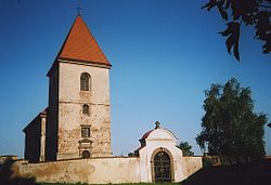
 Church of the Beheading of Saint John the Baptist | |
| Coordinates: 50°18′25″N 14°10′19″E | |
| Country | |
| Region | Central Bohemian |
| District | Kladno |
| First mentioned | 1318 |
| Area | |
| • Total | 8.07 km2 (3.12 sq mi) |
| Elevation | 196 m (643 ft) |
| Population (2024-01-01)[1] | |
| • Total | 563 |
| • Density | 70/km2 (180/sq mi) |
| Time zone | UTC+1 (CET) |
| • Summer (DST) | UTC+2 (CEST) |
| Postal code | 273 22 |
| Website | www |
The village of Hospozínek is an administrative part of Hospozín.
The name is derived from the old Czech word hospoz, meaning "lord's".[2]
Hospozín is located about 18 kilometres (11 mi) north of Kladno and 28 km (17 mi) northwest of Prague. It lies in a flat agricultural landscape in the Lower Ohře Table. The highest point is at 246 m (807 ft) above sea level. The stream Vranský potok flows through the municipality.
The first written mention of Hospozín is from 1318. Until the end of the 17th century, the village was owned by various lower noblemen. At the end of the 17th century, Hospozín was bought by the Clary-Aldringen family.[3]
There are no major roads passing through the municipality. The railway that runs through Hospozín is unused.
The main landmark of Hospozín is the Church of the Beheading of Saint John the Baptist. It was built in the Renaissance style in 1595 and modified in the Baroque style in 1712. It is a significant Renaissance monument.[6]
Seamless Wikipedia browsing. On steroids.
Every time you click a link to Wikipedia, Wiktionary or Wikiquote in your browser's search results, it will show the modern Wikiwand interface.
Wikiwand extension is a five stars, simple, with minimum permission required to keep your browsing private, safe and transparent.