File:Zaporizhzhia_region.png
From Wikipedia, the free encyclopedia
Size of this preview: 638 × 599 pixels. Other resolutions: 256 × 240 pixels | 511 × 480 pixels | 818 × 768 pixels | 1,090 × 1,024 pixels | 2,210 × 2,076 pixels.
Original file (2,210 × 2,076 pixels, file size: 781 KB, MIME type: image/png)
| This is a file from the Wikimedia Commons. Information from its description page there is shown below. Commons is a freely licensed media file repository. You can help. |

|
File:Russian Occupation of Zaporizhzhia Oblast.svg is a vector version of this file. It should be used in place of this PNG file when not inferior.
File:Zaporizhzhia region.png → File:Russian Occupation of Zaporizhzhia Oblast.svg
For more information, see Help:SVG.
|
 |
Summary
| DescriptionZaporizhzhia region.png |
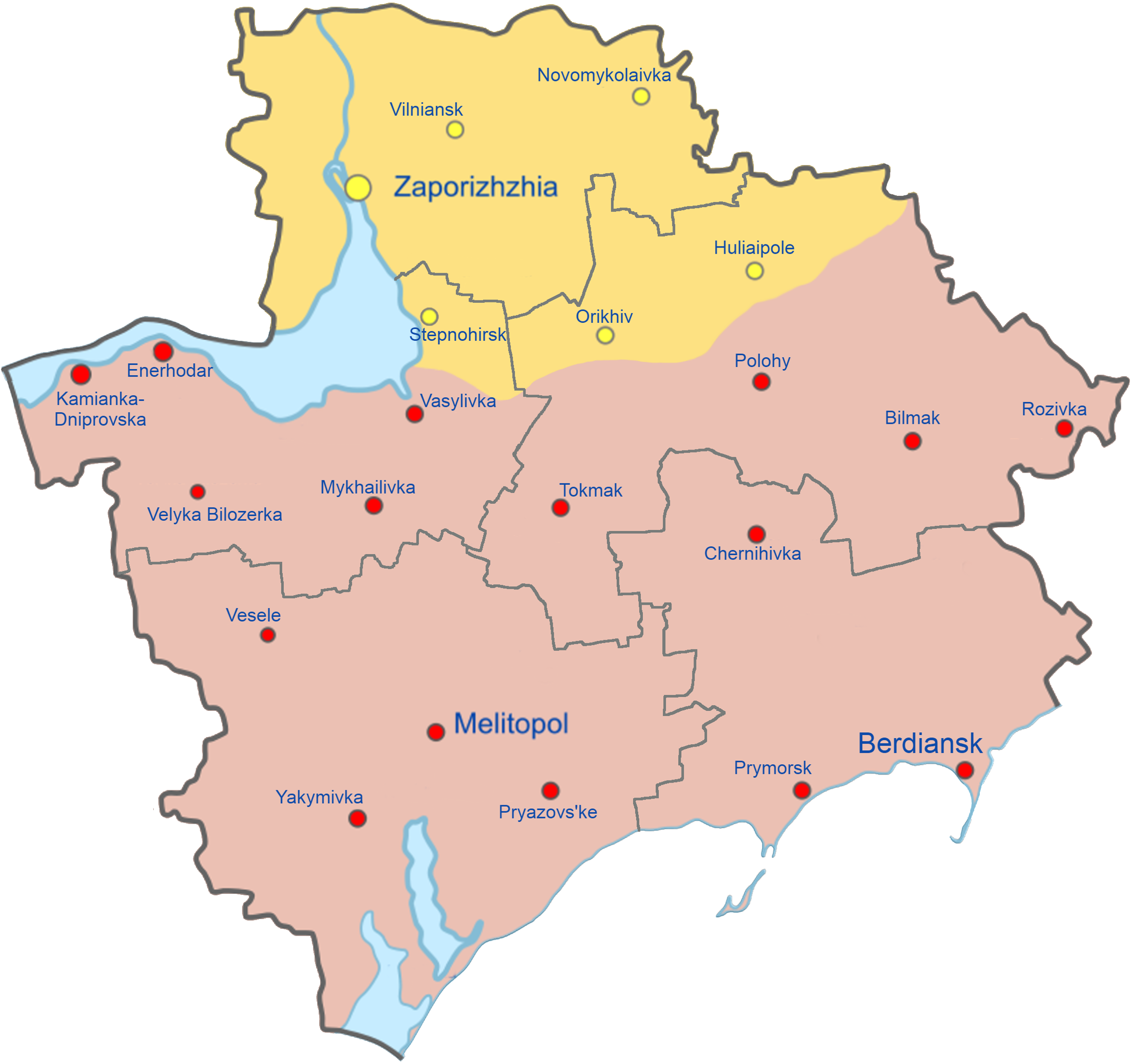
English: Map of Zaporizhzhia Oblast showing the rough zones of occupation during the southern offensive of the 2022 Russian invasion of Ukraine, as of August 2022.
Ukraine ( ) has maintained control over the north of the oblast, including the areas around the cities of Zaporizhzhia, Huliaipole and Orikhiv. The Russian occupation ( ) extends throughout the entire southern part of the oblast, including the major cities of Melitopol, Berdiansk and Enerhodar. |
| Date | |
| Source | Own work |
| Author | Qexypnos |
| Other versions |
[edit]
|


.png)


.png)


|
This file may be updated to reflect new information. If you wish to use a specific version of the file without new updates being mirrored, please upload the required version as a separate file. |
Licensing
I, the copyright holder of this work, hereby publish it under the following license:
This file is licensed under the Creative Commons Attribution-Share Alike 4.0 International license.
- You are free:
- to share – to copy, distribute and transmit the work
- to remix – to adapt the work
- Under the following conditions:
- attribution – You must give appropriate credit, provide a link to the license, and indicate if changes were made. You may do so in any reasonable manner, but not in any way that suggests the licensor endorses you or your use.
- share alike – If you remix, transform, or build upon the material, you must distribute your contributions under the same or compatible license as the original.
Captions
Territorial control in the Zaporizhzhia region.
Контроль територій у Запорізькій області.
Контроль территорий в Запорожской области.
Contrôle du territoire dans la région de Zaporizhzhia
Control territorial en la región de Zaporizhzhia
السيطرة الإقليمية في منطقة Zaporizhzhia.
扎波罗热地区的领土控制。
ザポリージャ地域の領土管理。
Teritoriālā kontrole Zaporožžas reģionā.
Lurralde kontrola Zaporizhzhia eskualdean.
Items portrayed in this file
depicts
26 June 2022
image/png
File history
Click on a date/time to view the file as it appeared at that time.
| Date/Time | Thumbnail | Dimensions | User | Comment | |
|---|---|---|---|---|---|
| current | 13:47, 11 July 2023 | | 2,210 × 2,076 (781 KB) | Iktsokh | Updated |
| 12:39, 1 August 2022 |  | 2,210 × 2,076 (995 KB) | Kaliper1 | Updated frontline borders based on File:2022 Russian invasion of Ukraine.svg. (see: https://commons.wikimedia.org/wiki/File:2022_Russian_invasion_of_Ukraine.svg), readjusted Raion borders based on Ministry of Development of Communities and Territories of Ukraine (see: https://www.minregion.gov.ua/press/news/novi-rajony-karty-sklad/), adjusted colors to be colorblind friendly, town/city names in Arial blue (standard Wikipedia format), removed unnecessary shadow, readjusted map projection, remo... | |
| 09:45, 1 August 2022 |  | 1,024 × 1,016 (300 KB) | Qexypnos | Correction | |
| 09:30, 1 August 2022 |  | 1,024 × 1,016 (324 KB) | Qexypnos | Correction | |
| 09:06, 1 August 2022 |  | 1,024 × 1,016 (336 KB) | Qexypnos | Correction | |
| 19:33, 31 July 2022 |  | 1,000 × 1,000 (354 KB) | DinoSoupCanada | Kept raion lines and other details, but made colors change for better viewing | |
| 21:12, 30 July 2022 |  | 1,750 × 1,016 (504 KB) | Qexypnos | Reverted to version as of 21:08, 30 July 2022 (UTC) | |
| 21:08, 30 July 2022 |  | 1,750 × 1,016 (502 KB) | Qexypnos | Reverted to version as of 21:06, 30 July 2022 (UTC) | |
| 21:08, 30 July 2022 |  | 1,750 × 1,016 (504 KB) | DinoSoupCanada | Reverted to version as of 19:28, 30 July 2022 (UTC) | |
| 21:07, 30 July 2022 |  | 2,276 × 2,048 (204 KB) | DinoSoupCanada | Reverted to version as of 09:11, 5 July 2022 (UTC) |
File usage
No pages on the English Wikipedia use this file (pages on other projects are not listed).
Global file usage
The following other wikis use this file:
- Usage on ar.wikipedia.org
- Usage on eu.wikipedia.org
- Usage on fr.wikipedia.org
- Usage on www.wikidata.org
Metadata
This file contains additional information, probably added from the digital camera or scanner used to create or digitize it.
If the file has been modified from its original state, some details may not fully reflect the modified file.
| Horizontal resolution | 37.79 dpc |
|---|---|
| Vertical resolution | 37.79 dpc |
Retrieved from "https://en.wikipedia.org/wiki/File:Zaporizhzhia_region.png"