File:Zamboanga_province_map_1918.JPG
From Wikipedia, the free encyclopedia
Size of this preview: 361 × 599 pixels. Other resolutions: 145 × 240 pixels | 617 × 1,023 pixels.
Original file (617 × 1,023 pixels, file size: 257 KB, MIME type: image/jpeg)
| This is a file from the Wikimedia Commons. Information from its description page there is shown below. Commons is a freely licensed media file repository. You can help. |
Summary
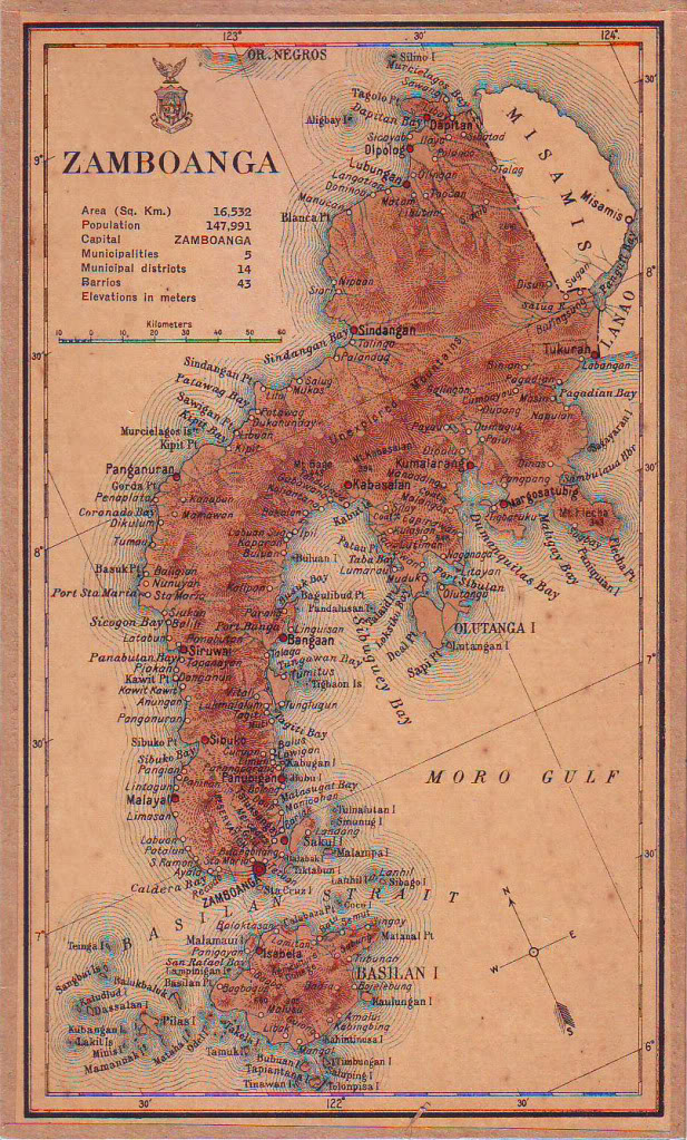
| DescriptionZamboanga province map 1918.JPG |
English: Map of Zamboanga province in 1918 |
| Date | |
| Source | Census of the Philippine Islands (1918) |
| Author | Census Office of the Philippine Islands |
Licensing
| Public domainPublic domainfalsefalse |
This media file is in the public domain in the United States. This applies to U.S. works where the copyright has expired, often because its first publication occurred prior to January 1, 1929, and if not then due to lack of notice or renewal. See this page for further explanation.
|
 | |
 |
This image might not be in the public domain outside of the United States; this especially applies in the countries and areas that do not apply the rule of the shorter term for US works, such as Canada, Mainland China (not Hong Kong or Macao), Germany, Mexico, and Switzerland. The creator and year of publication are essential information and must be provided. See Wikipedia:Public domain and Wikipedia:Copyrights for more details.
|
Captions
Add a one-line explanation of what this file represents
Items portrayed in this file
depicts
1920
File history
Click on a date/time to view the file as it appeared at that time.
| Date/Time | Thumbnail | Dimensions | User | Comment | |
|---|---|---|---|---|---|
| current | 04:13, 3 August 2015 | | 617 × 1,023 (257 KB) | Namayan | User created page with UploadWizard |
File usage
The following pages on the English Wikipedia use this file (pages on other projects are not listed):
Global file usage
The following other wikis use this file:
- Usage on bcl.wikipedia.org
- Usage on es.wikipedia.org
- Usage on ilo.wikipedia.org
- Usage on ka.wikipedia.org
- Usage on tl.wikipedia.org
Metadata
This file contains additional information, probably added from the digital camera or scanner used to create or digitize it.
If the file has been modified from its original state, some details may not fully reflect the modified file.
| Orientation | Normal |
|---|---|
| Horizontal resolution | 72 dpi |
| Vertical resolution | 150 dpi |
| Software used | Adobe Photoshop CS4 Windows |
| File change date and time | 14:39, 1 December 2010 |
| Y and C positioning | Centered |
| Exif version | 2.3 |
| Meaning of each component |
|
| Supported Flashpix version | 1 |
| Color space | Uncalibrated |
Retrieved from "https://en.wikipedia.org/wiki/File:Zamboanga_province_map_1918.JPG"