File:Wien_-_Regierungsgebäude,_Stubenring_1.JPG
From Wikipedia, the free encyclopedia
Size of this preview: 800 × 459 pixels. Other resolutions: 320 × 184 pixels | 640 × 367 pixels | 1,024 × 587 pixels | 1,280 × 734 pixels | 2,560 × 1,468 pixels | 4,724 × 2,709 pixels.
Original file (4,724 × 2,709 pixels, file size: 11.03 MB, MIME type: image/jpeg)
| This is a file from the Wikimedia Commons. Information from its description page there is shown below. Commons is a freely licensed media file repository. You can help. |
Summary
| DescriptionWien - Regierungsgebäude, Stubenring 1.JPG |
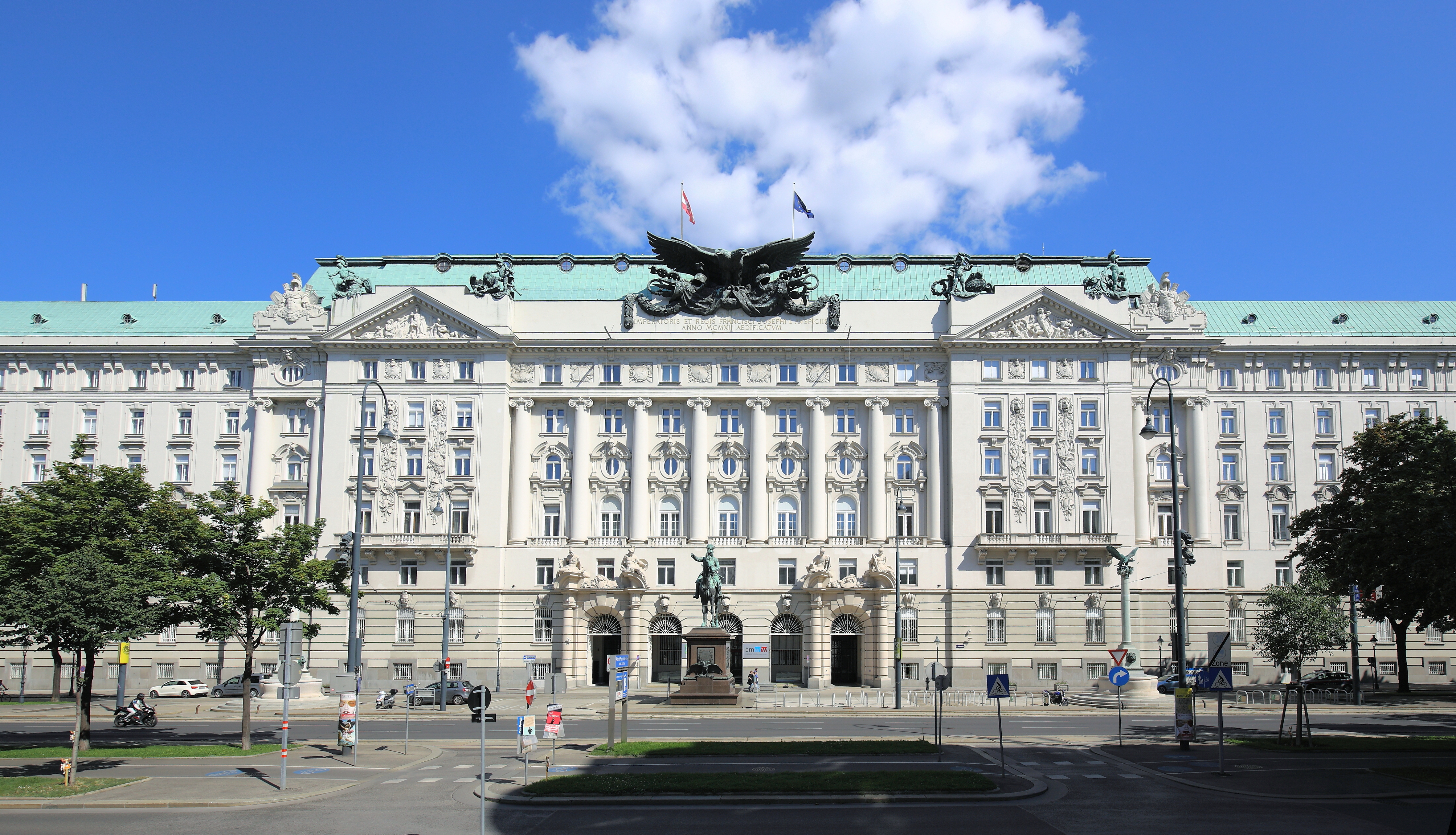
Deutsch: Das Regierungsgebäude und ehemalige k.u.k. Kriegsministerium am Stubenring 1 in der österreichischen Bundeshauptstadt Wien. Das Gebäude wurde in den Jahren 1909 bis 1913 von Ludwig Baumann errichtet. Bis zum Ende der Monarchie wurde das Gebäude vom k.u.k Kriegsministerium genutzt. Heute (2014) ist es der Sitz der Bundesministerien für Wissenschaft, Forschung und Wirtschaft sowie für Arbeit, Soziales und Konsumentenschutz.
Das Radetzky-Denkmal, ein Werk von Kaspar von Zumbusch und George Niemann (Sockel), stand ursprünglich auf dem Platz Am Hof und wurde am 24. April 1892 enthüllt. Nach dem Bau des Kriegsministeriums wurde es 1912 an dem heutigen Platz aufgestellt. Links und rechts des Radetzkydenkmals befinden sich zwei gleich gestaltete Brunnen mit hohen korinthischen Säulen und Doppeladler als Bekrönung. Der Entwurf dazu stammt vermutlich von Ludwig Baumann. Aufgestellt wurden sie im Zuge der Errichtung des Kriegsministeriums 1912.
|
||||||
| Date | |||||||
| Source | Own work | ||||||
| Author | C.Stadler/Bwag | ||||||
| Permission (Reusing this file) |
Deutsch: Hallo, du darfst mein Foto kostenlos nutzen, aber nenne mich bitte als Fotograf, beispielsweise „Foto: C.Stadler/Bwag“ oder © C.Stadler/Bwag; CC-BY-SA-4.0. Auf mehr Angaben bestehe ich nicht - im Gegensatz zu manch anderen, die die Vorgaben der unten angeführten Lizenzierung auf Punkt und Beistrich einfordern. English: Feel free to use my photos, but please mention me as the author like © C.Stadler/Bwag or © C.Stadler/Bwag; CC-BY-SA-4.0 (that's good enough) and if you want send me a message: bwag@gmx.net. |

| Camera location | 48° 12′ 35.94″ N, 16° 22′ 55.75″ E | View this and other nearby images on: OpenStreetMap |
|---|
| Object location | 48° 12′ 35.64″ N, 16° 22′ 58.37″ E | View this and other nearby images on: OpenStreetMap |
|---|
Licensing
I, the copyright holder of this work, hereby publish it under the following license:
This file is licensed under the Creative Commons Attribution-Share Alike 4.0 International license.
- You are free:
- to share – to copy, distribute and transmit the work
- to remix – to adapt the work
- Under the following conditions:
- attribution – You must give appropriate credit, provide a link to the license, and indicate if changes were made. You may do so in any reasonable manner, but not in any way that suggests the licensor endorses you or your use.
- share alike – If you remix, transform, or build upon the material, you must distribute your contributions under the same or compatible license as the original.
Captions
Add a one-line explanation of what this file represents
Items portrayed in this file
depicts
some value
48°12'35.939"N, 16°22'55.751"E
17 August 2014
48°12'35.6"N, 16°22'58.4"E
0.002 second
7.1
16 millimetre
100
image/jpeg
File history
Click on a date/time to view the file as it appeared at that time.
| Date/Time | Thumbnail | Dimensions | User | Comment | |
|---|---|---|---|---|---|
| current | 19:48, 20 August 2014 | | 4,724 × 2,709 (11.03 MB) | Bwag | {{Information |Description= {{de|1= Das Regierungsgebäude und ehemalige k.u.k. Kriegsministerium am Stubenring 1 in der österreichischen Bundeshauptstadt Wien. Das Gebäude wurde in den Jahren 1909 bis 1913 von [[:de:Ludwig Baumann|Ludw... |
File usage
The following pages on the English Wikipedia use this file (pages on other projects are not listed):
Global file usage
The following other wikis use this file:
- Usage on de.wikipedia.org
- Ministerium
- Wiener Ringstraße
- Rudolf Stöger-Steiner von Steinstätten
- Moritz von Auffenberg
- Ferdinand von Bauer
- Kriegsministerium (Wien)
- Ludwig Baumann (Architekt)
- Alexander von Krobatin
- Bundesministerium für Soziales, Gesundheit, Pflege und Konsumentenschutz
- Franz von John
- Edmund von Krieghammer
- Franz Kuhn von Kuhnenfeld
- Bundesministerium für Wirtschaft und Arbeit (Österreich)
- Alexander von Koller
- K.u.k. Kriegsministerium
- Artur Maximilian von Bylandt-Rheidt
- Heinrich von Pitreich
- Vorlage:Navigationsleiste k.u.k. Kriegsminister
- Rudolf von Merkl
- Franz Xaver von Schönaich
- Wikipedia:WikiProjekt Österreich/WD/Innere Stadt
- Benutzer:Stefan Fadinger/test2
- Verwendung von Kaiserstein als Baumaterial
- Wikipedia:WikiProjekt Österreich/checks/Denkmalschutz/WP - WD diffs 08
- Usage on de.wikivoyage.org
- Usage on el.wikipedia.org
- Usage on es.wikipedia.org
- Usage on fr.wikipedia.org
- Usage on he.wikipedia.org
- Usage on hu.wikipedia.org
- Usage on it.wikipedia.org
- Usage on la.wikipedia.org
- Usage on nl.wikipedia.org
- Usage on pl.wikipedia.org
- Usage on ru.wikipedia.org
- Usage on sr.wikipedia.org
- Usage on sv.wikipedia.org
- Usage on uk.wikipedia.org
- Usage on www.wikidata.org
Metadata
This file contains additional information, probably added from the digital camera or scanner used to create or digitize it.
If the file has been modified from its original state, some details may not fully reflect the modified file.
| Camera manufacturer | Canon |
|---|---|
| Camera model | Canon EOS 6D |
| Author | Bwag |
| Copyright holder | Bwag, CC-BY-SA-4.0 |
| Exposure time | 1/500 sec (0.002) |
| F-number | f/7.1 |
| ISO speed rating | 100 |
| Date and time of data generation | 14:29, 17 August 2014 |
| Lens focal length | 16 mm |
| Latitude | 48° 12′ 35.94″ N |
| Longitude | 16° 22′ 55.75″ E |
| Orientation | Normal |
| Horizontal resolution | 200 dpi |
| Vertical resolution | 200 dpi |
| File change date and time | 14:29, 17 August 2014 |
| Y and C positioning | Centered |
| Exif version | 2.3 |
| Date and time of digitizing | 14:29, 17 August 2014 |
| Meaning of each component |
|
| Shutter speed | 9 |
| APEX aperture | 5.625 |
| Exposure bias | 0.66666666666667 |
| Flash | Flash did not fire, compulsory flash suppression |
| Supported Flashpix version | 1 |
| Color space | sRGB |
| Focal plane X resolution | 3,810.5849582173 |
| Focal plane Y resolution | 3,815.89958159 |
| Focal plane resolution unit | inches |
| Custom image processing | Normal process |
| Exposure mode | Auto bracket |
| White balance | Auto white balance |
| Scene capture type | Standard |
| GPS time (atomic clock) | 13:20:8.701 |
| Satellites used for measurement | 11 |
| Receiver status | Measurement in progress |
| Geodetic survey data used | WGS-84 |
| GPS date | 17 August 2014 |
| GPS tag version | 0.0.3.2 |
| Rating (out of 5) | 0 |