File:Wien_-_Maria-Theresien-Denkmal.JPG
From Wikipedia, the free encyclopedia
Size of this preview: 800 × 533 pixels. Other resolutions: 320 × 213 pixels | 640 × 427 pixels | 1,024 × 683 pixels | 1,280 × 853 pixels | 2,560 × 1,707 pixels | 4,252 × 2,835 pixels.
Original file (4,252 × 2,835 pixels, file size: 10.44 MB, MIME type: image/jpeg)
| This is a file from the Wikimedia Commons. Information from its description page there is shown below. Commons is a freely licensed media file repository. You can help. |
Summary
| DescriptionWien - Maria-Theresien-Denkmal.JPG |
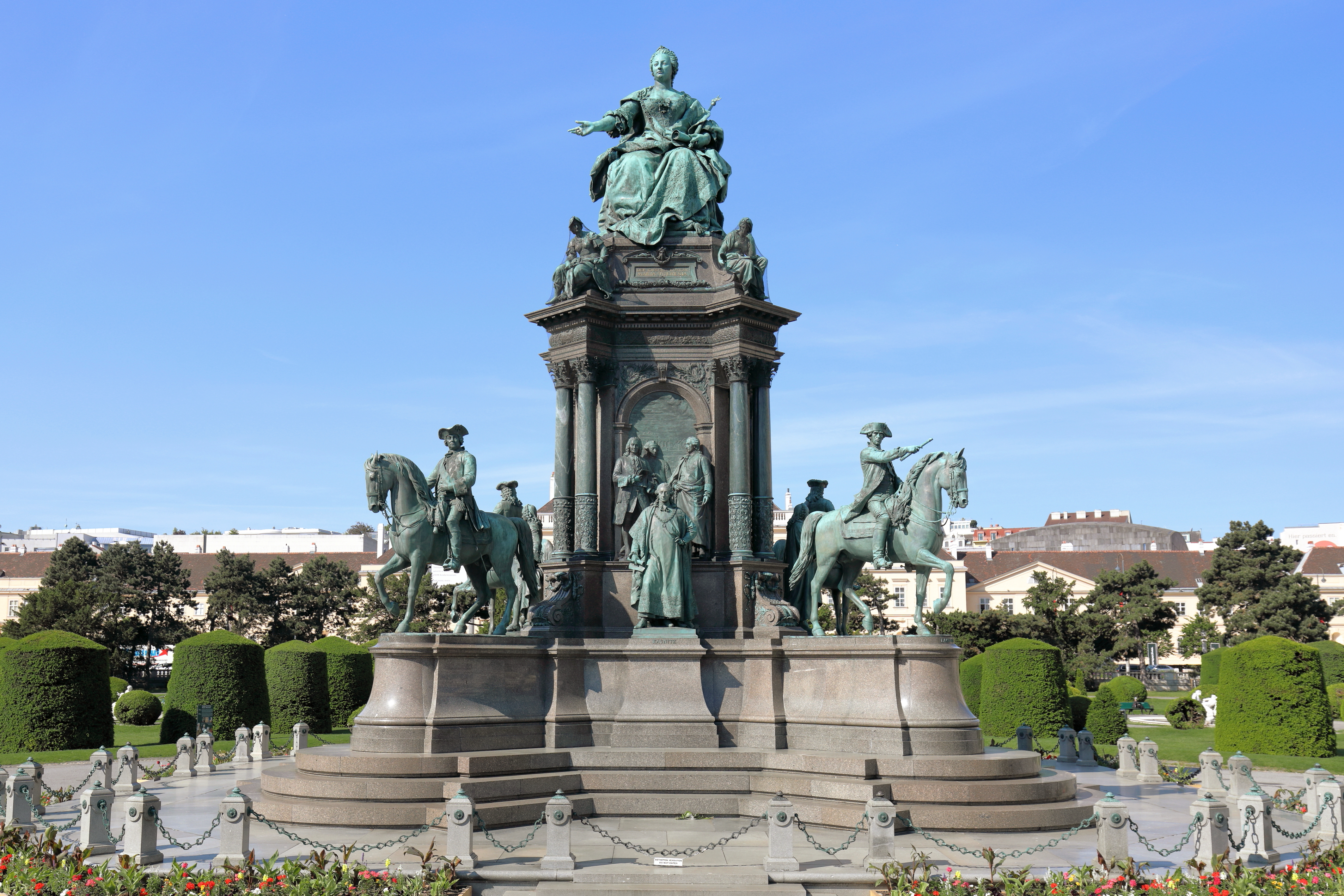
Deutsch: Das Maria-Theresien-Denkmal am Maria-Theresien-Platz im 1. Wiener Gemeindebezirk Innere Stadt.
Das imposanteste Werk der neueren plastischen Kunst in Wien wurde in 13 Jahren (Modell 1874, Vollendung 1887) von Caspar von Zumbusch (Plastiken) und Carl von Hasenauer (Bauwerk) geschaffen und am 13. Mai 1888, dem Geburtstag der Herrscherin, enthüllt. Auf den 4 Flügeln des Unterbaus befinden sich die Reiterstandbilder der Feldherren Gideon Ernst Freiherr von Loudon, Leopold Graf Daun, Ludwig Andreas Graf Khevenhüller und Otto Ferdinand Graf Abensberg-Traun. Die 4 Seiten des mittleren Aufbaus behandeln jeweils eine Thematik (Berater der Kaiserin, Verwaltung, Militär sowie Wissenschaft und Kunst. Wobei jeweils eine frei stehende Figur dargestellt ist (Berater: Wenzel Anton Dominik Graf Kaunitz; Verwaltung: Staatskanzler Friedrich Wilhelm Graf Haugwitz, Schöpfer der Verwaltungsreform; Militär: Joseph Wenzel Fürst Liechtenstein, Reorganisator des Geschützwesens; Wissenschaft und Kunst: Leibarzt Gerard van Swieten, Reformator der Universität) und 16 Figuren vor den Hochreliefs in den 4 Bogenfeldern.
|
|||
| Date | ||||
| Source | Own work | |||
| Author | C.Stadler/Bwag | |||
| Permission (Reusing this file) |
Deutsch: Hallo, du darfst mein Foto kostenlos nutzen, aber nenne mich bitte als Fotograf, beispielsweise „Foto: C.Stadler/Bwag“ oder © C.Stadler/Bwag; CC-BY-SA-4.0. Auf mehr Angaben bestehe ich nicht - im Gegensatz zu manch anderen, die die Vorgaben der unten angeführten Lizenzierung auf Punkt und Beistrich einfordern. English: Feel free to use my photos, but please mention me as the author like © C.Stadler/Bwag or © C.Stadler/Bwag; CC-BY-SA-4.0 (that's good enough) and if you want send me a message: bwag@gmx.net. |
|||
| Other versions |
|

.JPG)

| Camera location | 48° 12′ 16.92″ N, 16° 21′ 39.95″ E | View this and other nearby images on: OpenStreetMap |
|---|
Licensing
I, the copyright holder of this work, hereby publish it under the following license:
This file is licensed under the Creative Commons Attribution-Share Alike 4.0 International license.
- You are free:
- to share – to copy, distribute and transmit the work
- to remix – to adapt the work
- Under the following conditions:
- attribution – You must give appropriate credit, provide a link to the license, and indicate if changes were made. You may do so in any reasonable manner, but not in any way that suggests the licensor endorses you or your use.
- share alike – If you remix, transform, or build upon the material, you must distribute your contributions under the same or compatible license as the original.
Captions
Add a one-line explanation of what this file represents
Items portrayed in this file
depicts
some value
48°12'16.916"N, 16°21'39.946"E
22 May 2017
0.0025 second
6.3
30 millimetre
125
image/jpeg
File history
Click on a date/time to view the file as it appeared at that time.
| Date/Time | Thumbnail | Dimensions | User | Comment | |
|---|---|---|---|---|---|
| current | 19:34, 22 May 2017 | | 4,252 × 2,835 (10.44 MB) | Bwag | wb |
| 16:08, 22 May 2017 |  | 4,252 × 2,835 (10.05 MB) | Bwag | {{Information |Description= {{de|1=Das Maria-Theresien-Denkmal am Maria-Theresien-Platz im 1. Wiener Gemeindebezirk Innere Stadt.<br/>Das imposantes... |
File usage
The following pages on the English Wikipedia use this file (pages on other projects are not listed):
Global file usage
The following other wikis use this file:
- Usage on cs.wikipedia.org
- Usage on de.wikipedia.org
- Usage on de.wikivoyage.org
- Usage on es.wikipedia.org
- Usage on fr.wikipedia.org
- Usage on it.wikipedia.org
- Usage on ru.wikipedia.org
- Usage on uk.wikipedia.org
- Usage on www.wikidata.org
Metadata
This file contains additional information, probably added from the digital camera or scanner used to create or digitize it.
If the file has been modified from its original state, some details may not fully reflect the modified file.
| Camera manufacturer | Canon |
|---|---|
| Camera model | Canon EOS 5D Mark IV |
| Author | Bwag |
| Copyright holder | Bwag, CC-BY-SA-4.0 |
| Exposure time | 1/400 sec (0.0025) |
| F-number | f/6.3 |
| ISO speed rating | 125 |
| Date and time of data generation | 08:11, 22 May 2017 |
| Lens focal length | 30 mm |
| Latitude | 48° 12′ 16.99″ N |
| Longitude | 16° 21′ 39.72″ E |
| Altitude | 186.1 meters above sea level |
| height | 2,835 |
| width | 4,252 |
| Orientation | Normal |
| Horizontal resolution | 350 dpi |
| Vertical resolution | 350 dpi |
| Software used | Digital Photo Professional |
| File change date and time | 08:11, 22 May 2017 |
| Y and C positioning | Centered |
| Exposure Program | Aperture priority |
| Exif version | 2.3 |
| Date and time of digitizing | 08:11, 22 May 2017 |
| Meaning of each component |
|
| Shutter speed | 8.625 |
| APEX aperture | 5.375 |
| Exposure bias | 0.66666666666667 |
| Metering mode | Pattern |
| Flash | Flash did not fire, compulsory flash suppression |
| DateTime subseconds | 28 |
| DateTimeOriginal subseconds | 28 |
| DateTimeDigitized subseconds | 28 |
| Supported Flashpix version | 1 |
| Color space | sRGB |
| Custom image processing | Normal process |
| Exposure mode | Auto bracket |
| White balance | Auto white balance |
| Scene capture type | Standard |
| GPS time (atomic clock) | 07:11:9.908 |
| Satellites used for measurement | 6 |
| Receiver status | Measurement in progress |
| Measurement mode | 3-dimensional measurement |
| Measurement precision | Poor (3) |
| Geodetic survey data used | WGS-84 |
| GPS date | 22 May 2017 |
| GPS tag version | 0.0.3.2 |
| Rating (out of 5) | 0 |