File:Van_de_Brook's_map.jpg
From Wikipedia, the free encyclopedia
Size of this preview: 747 × 600 pixels. Other resolutions: 299 × 240 pixels | 598 × 480 pixels | 956 × 768 pixels | 1,275 × 1,024 pixels | 1,433 × 1,151 pixels.
Original file (1,433 × 1,151 pixels, file size: 891 KB, MIME type: image/jpeg)
| This is a file from the Wikimedia Commons. Information from its description page there is shown below. Commons is a freely licensed media file repository. You can help. |
Summary
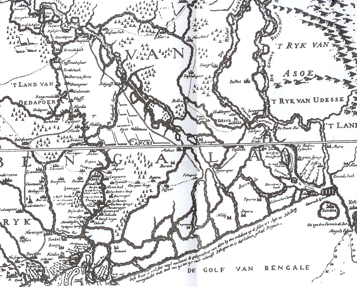
| DescriptionVan de Brook's map.jpg | This is one of the earliest published maps of Bengal. This early map is, however, an inaccurate depiction. The map was published in 1660. |
| Date | |
| Source | Bangalir Itihas by Niharranjan Roy, Bengali, first published 1972, reprint 2005, Dey’s Publishing, 13 Bankim Chatterjee Street, Kolkata, ISBN 81-7079-270-3 |
| Author | Van den Brouck |
Licensing
| Public domainPublic domainfalsefalse |
|
This work is in the public domain in its country of origin and other countries and areas where the copyright term is the author's life plus 100 years or fewer. | |
| This file has been identified as being free of known restrictions under copyright law, including all related and neighboring rights. | |
https://creativecommons.org/publicdomain/mark/1.0/PDMCreative Commons Public Domain Mark 1.0falsefalse
Original upload log
The original description page was here. All following user names refer to en.wikipedia.
- 2007-11-21 06:54 P.K.Niyogi 1433×1151× (968840 bytes) Source: ''Bangalir Itihas'' by Niharranjan Roy {{Bn icon}}. The map was published in 1660
Captions
Add a one-line explanation of what this file represents
Items portrayed in this file
depicts
1660
File history
Click on a date/time to view the file as it appeared at that time.
| Date/Time | Thumbnail | Dimensions | User | Comment | |
|---|---|---|---|---|---|
| current | 07:51, 23 October 2015 | | 1,433 × 1,151 (891 KB) | Opencooper | Remove bug from center of image |
| 20:51, 20 October 2011 |  | 1,433 × 1,151 (946 KB) | OgreBot | (BOT): Uploading old version of file from en.wikipedia; originally uploaded on 2007-11-21 06:54:33 by P.K.Niyogi | |
| 06:34, 24 November 2007 |  | 747 × 600 (165 KB) | Tarif | {{Information |Description= |Source= |Date= |Author= |Permission={{PD-old}} |other_versions= }} |
File usage
The following pages on the English Wikipedia use this file (pages on other projects are not listed):
Global file usage
The following other wikis use this file:
- Usage on as.wikipedia.org
- Usage on bh.wikipedia.org
- Usage on bn.wikipedia.org
- Usage on de.wikipedia.org
- Usage on es.wikipedia.org
- Usage on sat.wikipedia.org
- Usage on sl.wikipedia.org
- Usage on ta.wikipedia.org
Metadata
This file contains additional information, probably added from the digital camera or scanner used to create or digitize it.
If the file has been modified from its original state, some details may not fully reflect the modified file.
| Camera manufacturer | HP |
|---|---|
| Camera model | HP psc2200 |
| Horizontal resolution | 200 dpi |
| Vertical resolution | 200 dpi |
| Y and C positioning | Co-sited |
| Pair of black and white reference values |
|
| Exif version | 2.2 |
| Meaning of each component |
|
| Supported Flashpix version | 1 |
| Color space | sRGB |
| Image width | 1,433 px |
| Image height | 1,151 px |
Retrieved from "https://en.wikipedia.org/wiki/File:Van_de_Brook%27s_map.jpg"