File:UAE_en-map.png
From Wikipedia, the free encyclopedia
Size of this preview: 755 × 600 pixels. Other resolutions: 302 × 240 pixels | 605 × 480 pixels | 967 × 768 pixels | 1,280 × 1,017 pixels | 1,414 × 1,123 pixels.
Original file (1,414 × 1,123 pixels, file size: 214 KB, MIME type: image/png)
| This is a file from the Wikimedia Commons. Information from its description page there is shown below. Commons is a freely licensed media file repository. You can help. |
Summary
| DescriptionUAE en-map.png |
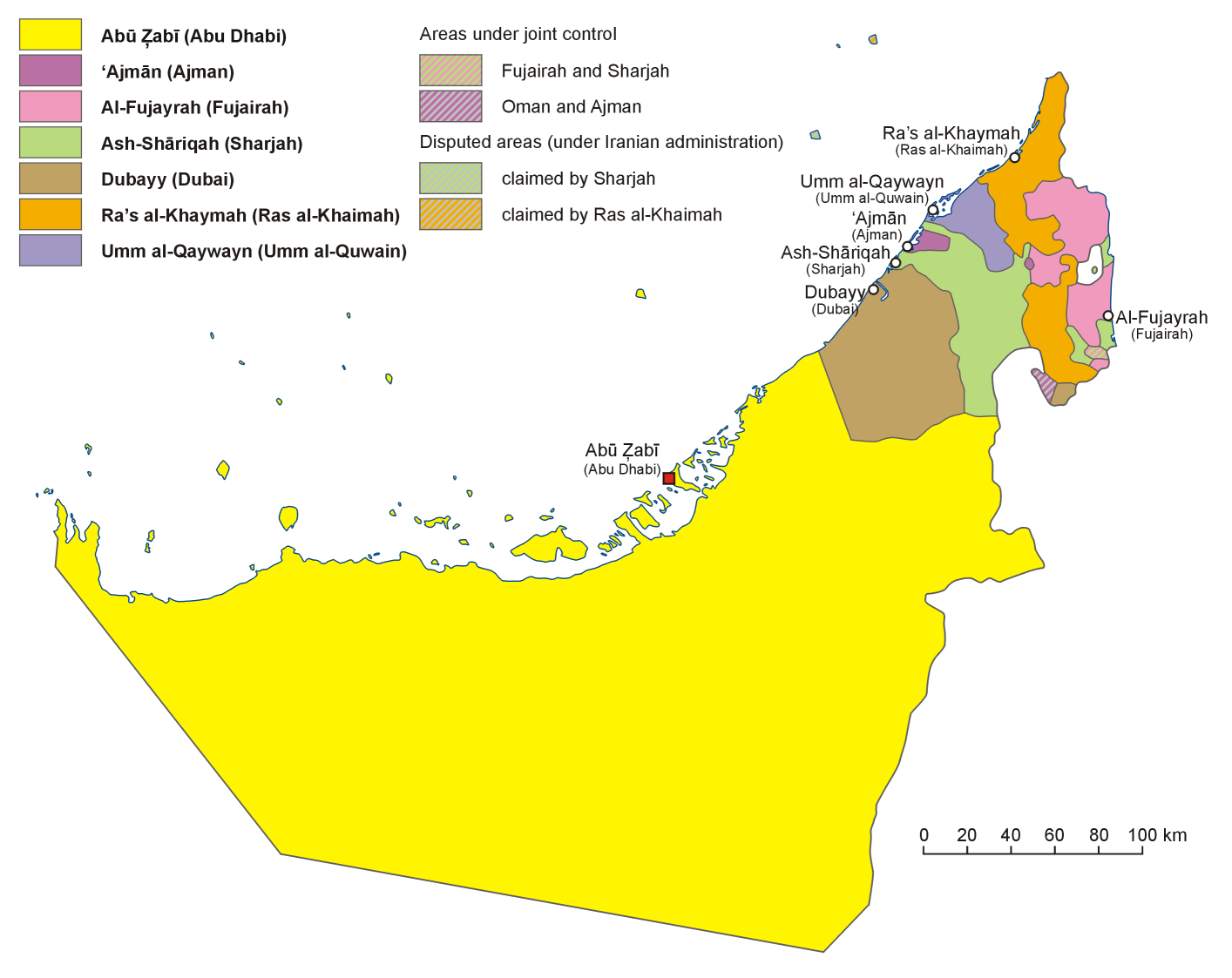
English: Administrative map of the United Arab Emirates in English
فارسی: نقشهٔ اداری امارات متحده عربی به فارسی
Français : Carte des divisions administratives des Emirats arabes unis en Anglais
Italiano: Carta politica degli Emirati Arabi Uniti, in inglese
Hrvatski: Politički zemljovid Ujedinjenih Arapskih Emirata, inačica na engleskom
Polski: Mapa administracyjna Zjednoczonych Emiratów Arabskich, wersja anglojęzyczna
日本語: アラブ首長国連邦の行政区分図(英語版)
Српски / srpski: Политичка карта Уједињених Арапских Емирата, верзија на енглеском језику. |
| Date | |
| Source | Own work, based on map of the United Arab Emirates published in Wielki Encyklopedyczny Atlas Świata (The Great Encyclopedian World Atlas), vol. 10 Azja Południowo-Zachodnia (Southwest Asia), Polish Scientific Publishers PWN, Warsaw 2006, p. 76-78 |
| Author | Aotearoa |
| Other versions |
Derivative works of this file: |
Licensing
I, the copyright holder of this work, hereby publish it under the following license:

|
Permission is granted to copy, distribute and/or modify this document under the terms of the GNU Free Documentation License, Version 1.2 or any later version published by the Free Software Foundation; with no Invariant Sections, no Front-Cover Texts, and no Back-Cover Texts. A copy of the license is included in the section entitled GNU Free Documentation License.http://www.gnu.org/copyleft/fdl.htmlGFDLGNU Free Documentation Licensetruetrue |
| This file is licensed under the Creative Commons Attribution-Share Alike 3.0 Unported license. | ||
| ||
| This licensing tag was added to this file as part of the GFDL licensing update.http://creativecommons.org/licenses/by-sa/3.0/CC BY-SA 3.0Creative Commons Attribution-Share Alike 3.0truetrue |
Captions
Add a one-line explanation of what this file represents
Items portrayed in this file
depicts
5 January 2007
File history
Click on a date/time to view the file as it appeared at that time.
| Date/Time | Thumbnail | Dimensions | User | Comment | |
|---|---|---|---|---|---|
| current | 10:52, 13 August 2013 | | 1,414 × 1,123 (214 KB) | Aotearoa | Reverted to version as of 20:41, 5 January 2007 |
| 17:47, 12 August 2013 |  | 1,414 × 1,123 (184 KB) | Cromium | Clarified by removing transliterations of the emirate names, leaving just the English names used in the relevant Wikipedia articles | |
| 20:41, 5 January 2007 |  | 1,414 × 1,123 (214 KB) | Aotearoa | Administrative map of United Arab Emirates. Created by Aotearoa |
File usage
The following pages on the English Wikipedia use this file (pages on other projects are not listed):
- Al Karama, United Arab Emirates
- December 1971
- List of British representatives in the Trucial States
- United Arab Emirates
- User:Jonny-mt/Gallery of current first-level administrative country subdivisions maps
- Wikipedia talk:WikiProject Western Asia/Archive 1
- Template:UAE midsize imagemap with emirate names
Global file usage
The following other wikis use this file:
- Usage on ace.wikipedia.org
- Usage on af.wikipedia.org
- Usage on ang.wikipedia.org
- Usage on ar.wikipedia.org
- Usage on ast.wikipedia.org
- Usage on bn.wikipedia.org
- Usage on br.wikipedia.org
- Usage on cs.wikipedia.org
- Spojené arabské emiráty
- Abú Zabí
- Dubaj (emirát)
- Vlajka Spojených arabských emirátů
- Rás al-Chajma (emirát)
- Fudžajra (emirát)
- Abú Zabí (emirát)
- Šablona:Emiráty SAE
- Adžmán (emirát)
- Šardžá (emirát)
- Dubaj
- Fudžajra
- Rás al-Chajma
- Šardžá
- Umm al-Kuvajn (emirát)
- Emiráty Spojených arabských emirátů
- Adžmán
- Umm al-Kuvajn
- Usage on de.wikipedia.org
- Usage on eo.wikipedia.org
- Usage on es.wikipedia.org
- Usage on et.wikipedia.org
- Usage on eu.wikipedia.org
View more global usage of this file.
Metadata
This file contains additional information, probably added from the digital camera or scanner used to create or digitize it.
If the file has been modified from its original state, some details may not fully reflect the modified file.
| PNG file comment | |
|---|---|
| Horizontal resolution | 118.11 dpc |
| Vertical resolution | 118.11 dpc |
Retrieved from "https://en.wikipedia.org/wiki/File:UAE_en-map.png"