File:Turning_bridge_Kendal.jpg
From Wikipedia, the free encyclopedia
No higher resolution available.
Turning_bridge_Kendal.jpg (640 × 480 pixels, file size: 163 KB, MIME type: image/jpeg)
| This is a file from the Wikimedia Commons. Information from its description page there is shown below. Commons is a freely licensed media file repository. You can help. |
Summary
| DescriptionTurning bridge Kendal.jpg |
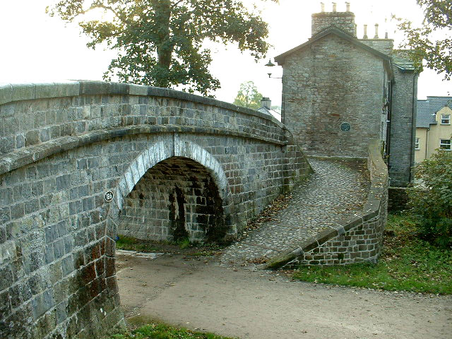
English: The Change Bridge, Kendal |
| Date | |
| Source |
This file was derived from: The Change Bridge, Kendal - geograph.org.uk - 71072.jpg |
| Author | David Medcalf |
| Permission (Reusing this file) |
Creative Commons Attribution Share-alike license 2.0 |
| Camera location | 54° 19′ 10.25″ N, 2° 44′ 21.92″ W | View this and other nearby images on: OpenStreetMap |
|---|
| Object location | 54° 19′ 09″ N, 2° 44′ 20″ W | View this and other nearby images on: OpenStreetMap |
|---|
Licensing
This file is licensed under the Creative Commons Attribution-Share Alike 2.0 Generic license.
Attribution: David Medcalf
- You are free:
- to share – to copy, distribute and transmit the work
- to remix – to adapt the work
- Under the following conditions:
- attribution – You must give appropriate credit, provide a link to the license, and indicate if changes were made. You may do so in any reasonable manner, but not in any way that suggests the licensor endorses you or your use.
- share alike – If you remix, transform, or build upon the material, you must distribute your contributions under the same or compatible license as the original.
Captions
Add a one-line explanation of what this file represents
Items portrayed in this file
depicts
some value
23 October 2005
54°19'10.247"N, 2°44'21.916"W
54°19'8.8"N, 2°44'20.4"W
3.5
6 millimetre
100
image/jpeg
File history
Click on a date/time to view the file as it appeared at that time.
| Date/Time | Thumbnail | Dimensions | User | Comment | |
|---|---|---|---|---|---|
| current | 17:52, 19 May 2006 | | 640 × 480 (163 KB) | Blisco | ''The Turning Bridge, Kendal'' Situated on the long disused section of the Lancaster Canal, this bridge allowed the Tow Horses to change from one side of the canal to the other [as the tow path changed sides] without unhitching from the barge they were t |
File usage
The following pages on the English Wikipedia use this file (pages on other projects are not listed):
Global file usage
The following other wikis use this file:
- Usage on azb.wikipedia.org
- Usage on dag.wikipedia.org
- Usage on www.wikidata.org
Metadata
This file contains additional information, probably added from the digital camera or scanner used to create or digitize it.
If the file has been modified from its original state, some details may not fully reflect the modified file.
| Camera manufacturer | FUJIFILM |
|---|---|
| Camera model | FinePix2600Zoom |
| F-number | f/3.5 |
| ISO speed rating | 100 |
| Date and time of data generation | 14:49, 23 October 2005 |
| Lens focal length | 6 mm |
| Orientation | Normal |
| Horizontal resolution | 72 dpi |
| Vertical resolution | 72 dpi |
| Software used | Adobe Photoshop CS Windows |
| File change date and time | 18:36, 19 May 2006 |
| Y and C positioning | Co-sited |
| Exposure Program | Normal program |
| Exif version | 2.1 |
| Date and time of digitizing | 14:49, 23 October 2005 |
| Meaning of each component |
|
| Image compression mode | 2 |
| Shutter speed | 5.6 |
| APEX aperture | 3.6 |
| APEX brightness | 4.66 |
| Exposure bias | 0 |
| Maximum land aperture | 3.6 APEX (f/3.48) |
| Metering mode | Pattern |
| Flash | Flash did not fire |
| Supported Flashpix version | 1 |
| Color space | sRGB |
| Focal plane X resolution | 2,442 |
| Focal plane Y resolution | 2,442 |
| Focal plane resolution unit | 3 |
| Sensing method | One-chip color area sensor |
| File source | Digital still camera |
| Scene type | A directly photographed image |
| Supported Flashpix version | 1 |
| Image width | 640 px |
| Image height | 480 px |
| Date metadata was last modified | 18:36, 19 May 2006 |
| IIM version | 2 |
Retrieved from "https://en.wikipedia.org/wiki/File:Turning_bridge_Kendal.jpg"