File:Trockenklimate.png
From Wikipedia, the free encyclopedia
Original file (3,600 × 1,800 pixels, file size: 647 KB, MIME type: image/png)
| This is a file from the Wikimedia Commons. Information from its description page there is shown below. Commons is a freely licensed media file repository. You can help. |
Summary
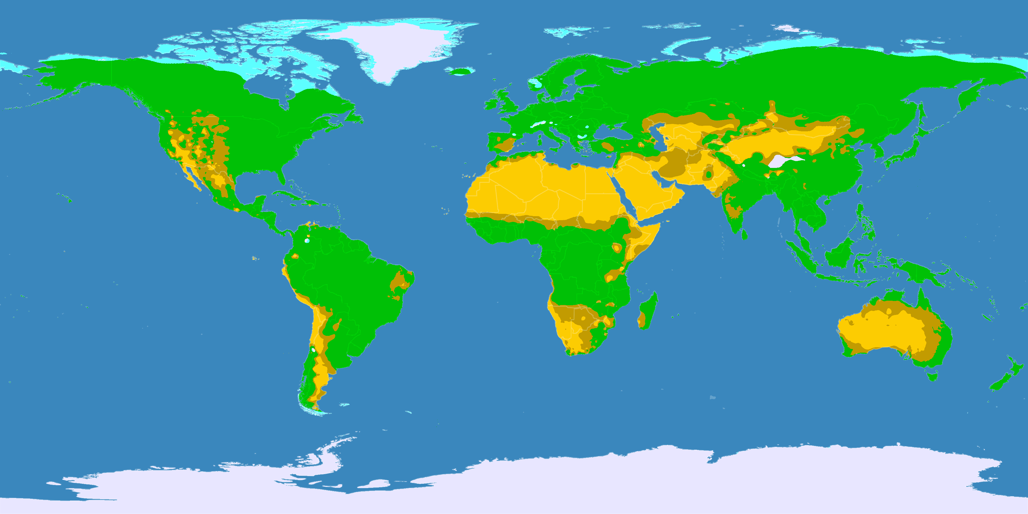
| DescriptionTrockenklimate.png |
English: This map shows the Earth zones with a dry climate.
Deutsch: Diese Karte zeigt die verschiedenen trockenen Klimazonen der Erde.
Italiano: Mappa delle zone desertiche
Norsk bokmål: Kart over verdens tørre klimasoner.
|
||
| Date | |||
| Source |
English: Own work on the basis of the following data: Deutsch: Selbst erstellt auf Basis dieser Geodaten:
|
||
| Creator | |||
| Permission (Reusing this file) |
|
||
| Georeferencing | Georeference the map in Wikimaps Warper If inappropriate please set warp_status = skip to hide. | ||
| Other versions |
|


Licensing
- You are free:
- to share – to copy, distribute and transmit the work
- to remix – to adapt the work
- Under the following conditions:
- attribution – You must give appropriate credit, provide a link to the license, and indicate if changes were made. You may do so in any reasonable manner, but not in any way that suggests the licensor endorses you or your use.
- share alike – If you remix, transform, or build upon the material, you must distribute your contributions under the same or compatible license as the original.
Captions
Items portrayed in this file
depicts
image/png
File history
Click on a date/time to view the file as it appeared at that time.
| Date/Time | Thumbnail | Dimensions | User | Comment | |
|---|---|---|---|---|---|
| current | 21:03, 11 October 2016 | | 3,600 × 1,800 (647 KB) | Maphobbyist | The Caspian Sea was omitted. The Köppen system is based on the concept that climate types are correlated with the natural vegetation. |
| 12:25, 29 January 2013 |  | 3,600 × 1,800 (530 KB) | GDK | humid areas colured green (formerly light grey) for better recognizability | |
| 17:25, 15 October 2007 |  | 3,600 × 1,800 (623 KB) | Lortordermur | == Beschreibung == {{Information |Description=Diese Karte stellt die trockenen Klimate der Erde dar. {{legend|#ffcc00|Wüstenklima}} {{legend|#c69e00|Savannenklima}} {{legend|#65ffff|Tundrenklima}} {{legend|#eaeaff|Eisklima}} |Source=Selbst erstellt auf |
File usage
Global file usage
The following other wikis use this file:
- Usage on bar.wikipedia.org
- Usage on ba.wikipedia.org
- Usage on bg.wikipedia.org
- Usage on ce.wikipedia.org
- Usage on ckb.wikipedia.org
- Usage on crh.wikipedia.org
- Usage on da.wikipedia.org
- Usage on da.wikibooks.org
- Usage on de.wikipedia.org
- Usage on de.wikiversity.org
- Usage on eo.wikipedia.org
- Usage on et.wikipedia.org
- Usage on fa.wikipedia.org
- Usage on fi.wikipedia.org
- Usage on frr.wikipedia.org
- Usage on hu.wikipedia.org
- Usage on hy.wikipedia.org
- Usage on hyw.wikipedia.org
- Usage on inh.wikipedia.org
- Usage on it.wikipedia.org
- Usage on ja.wikipedia.org
- Usage on kaa.wikipedia.org
- Usage on ka.wikipedia.org
- Usage on krc.wikipedia.org
- Usage on la.wikipedia.org
- Usage on lld.wikipedia.org
- Usage on lv.wikipedia.org
- Usage on nds.wikipedia.org
- Usage on nl.wikipedia.org
- Usage on no.wikipedia.org
- Usage on pt.wikipedia.org
- Usage on roa-tara.wikipedia.org
- Usage on ro.wikipedia.org
- Usage on ru.wikipedia.org
- Usage on sc.wikipedia.org
- Usage on sr.wikipedia.org
View more global usage of this file.
Metadata
This file contains additional information, probably added from the digital camera or scanner used to create or digitize it.
If the file has been modified from its original state, some details may not fully reflect the modified file.
| Horizontal resolution | 37.79 dpc |
|---|---|
| Vertical resolution | 37.79 dpc |