File:Theoreticaltownshipmap.gif
From Wikipedia, the free encyclopedia
Size of this preview: 554 × 600 pixels. Other resolutions: 222 × 240 pixels | 444 × 480 pixels | 694 × 751 pixels.
Original file (694 × 751 pixels, file size: 70 KB, MIME type: image/gif)
| This is a file from the Wikimedia Commons. Information from its description page there is shown below. Commons is a freely licensed media file repository. You can help. |
Summary
| DescriptionTheoreticaltownshipmap.gif |
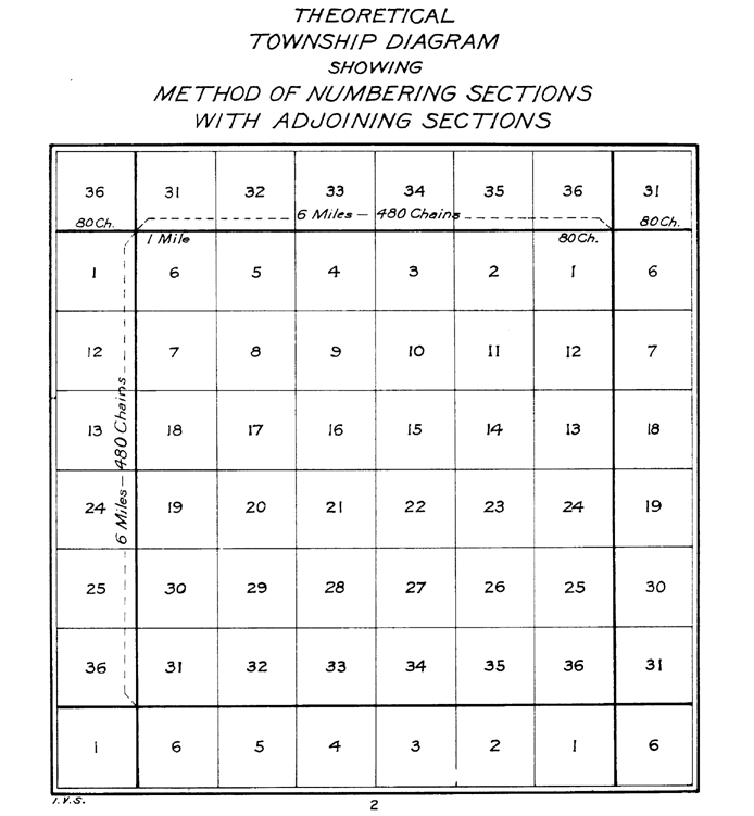
English: The image depicts a standard survey township with its 36 sections and the correponding sections from the surrounding survey townships. |
||||
| Date | |||||
| Source | The image was tansferred from the en.wiki. If necessary, it could be found here. | ||||
| Author |
The image was done by the US Interior Bureau of Land Management
|
Licensing
| Public domainPublic domainfalsefalse |
This work is in the public domain in the United States because it is a work prepared by an officer or employee of the United States Government as part of that person’s official duties under the terms of Title 17, Chapter 1, Section 105 of the US Code.
Note: This only applies to original works of the Federal Government and not to the work of any individual U.S. state, territory, commonwealth, county, municipality, or any other subdivision. This template also does not apply to postage stamp designs published by the United States Postal Service since 1978. (See § 313.6(C)(1) of Compendium of U.S. Copyright Office Practices). It also does not apply to certain US coins; see The US Mint Terms of Use.
|
 | |
| This file has been identified as being free of known restrictions under copyright law, including all related and neighboring rights. | ||
https://creativecommons.org/publicdomain/mark/1.0/PDMCreative Commons Public Domain Mark 1.0falsefalse
| Public domainPublic domainfalsefalse |
| This image is a work of a Bureau of Land Management* employee, taken or made as part of that person's official duties. As a work of the U.S. federal government, the image is in the public domain in the United States. *or predecessor organization |
Captions
Add a one-line explanation of what this file represents
Items portrayed in this file
depicts
22 December 2011
File history
Click on a date/time to view the file as it appeared at that time.
| Date/Time | Thumbnail | Dimensions | User | Comment | |
|---|---|---|---|---|---|
| current | 21:25, 22 December 2011 | | 694 × 751 (70 KB) | Wars |
File usage
The following pages on the English Wikipedia use this file (pages on other projects are not listed):
Global file usage
The following other wikis use this file:
- Usage on ca.wikipedia.org
- Usage on fr.wikipedia.org
- Usage on hu.wikipedia.org
- Usage on it.wikipedia.org
- Usage on ro.wikipedia.org
Retrieved from "https://en.wikipedia.org/wiki/File:Theoreticaltownshipmap.gif"