File:The_main_causeway_to_Ynys_Gaint_-_geograph.org.uk_-_586380.jpg
From Wikipedia, the free encyclopedia
No higher resolution available.
The_main_causeway_to_Ynys_Gaint_-_geograph.org.uk_-_586380.jpg (640 × 480 pixels, file size: 99 KB, MIME type: image/jpeg)
| This is a file from the Wikimedia Commons. Information from its description page there is shown below. Commons is a freely licensed media file repository. You can help. |
Summary
| DescriptionThe main causeway to Ynys Gaint - geograph.org.uk - 586380.jpg |
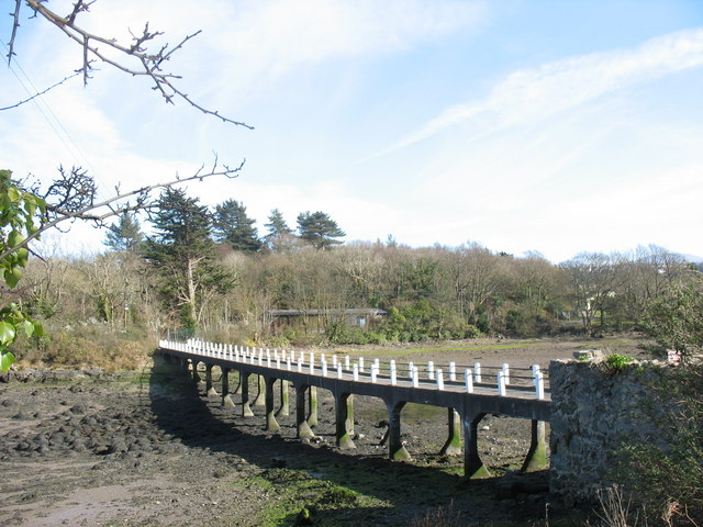
English: The main causeway to Ynys Gaint I spent many a weekend on Ynys Gaint when it was a base for the Royal Corps of Transport (Amphibious) [Wales]and used as a WTC for other units involved in mountain and water activities training. In those pre-breathalyser days it needed skill and a lot of luck to manoeuvre a long wheel base Land Rover back across the causeway after closing time on Saturday. Though the hutments are still on the island, and a parliamentary answer of 2002 lists Ynys Gaint as one of the MOD's bases on Anglesey, the only sign at the roadway end of the causeway nowadays is a 'Private. No Entry" sign. |
| Date | |
| Source | From geograph.org.uk |
| Author | Eric Jones |
| Attribution (required by the license) InfoField | Eric Jones / The main causeway to Ynys Gaint / |
InfoField | Eric Jones / The main causeway to Ynys Gaint |
| Camera location | 53° 13′ 53″ N, 4° 09′ 31″ W | View this and other nearby images on: OpenStreetMap |
|---|
| Object location | 53° 13′ 51″ N, 4° 09′ 29″ W | View this and other nearby images on: OpenStreetMap |
|---|
Licensing

|
This image was taken from the Geograph project collection. See this photograph's page on the Geograph website for the photographer's contact details. The copyright on this image is owned by Eric Jones and is licensed for reuse under the Creative Commons Attribution-ShareAlike 2.0 license.
|
This file is licensed under the Creative Commons Attribution-Share Alike 2.0 Generic license.
Attribution: Eric Jones
- You are free:
- to share – to copy, distribute and transmit the work
- to remix – to adapt the work
- Under the following conditions:
- attribution – You must give appropriate credit, provide a link to the license, and indicate if changes were made. You may do so in any reasonable manner, but not in any way that suggests the licensor endorses you or your use.
- share alike – If you remix, transform, or build upon the material, you must distribute your contributions under the same or compatible license as the original.
Captions
Add a one-line explanation of what this file represents
Items portrayed in this file
depicts
some value
4 April 2007
53°13'53.22"N, 4°9'30.96"W
53°13'51.31"N, 4°9'28.80"W
0.004 second
7.3 millimetre
File history
Click on a date/time to view the file as it appeared at that time.
| Date/Time | Thumbnail | Dimensions | User | Comment | |
|---|---|---|---|---|---|
| current | 15:35, 6 February 2011 | | 640 × 480 (99 KB) | GeographBot | == {{int:filedesc}} == {{Information |description={{en|1=The main causeway to Ynys Gaint I spent many a weekend on Ynys Gaint when it was a base for the Royal Crops of Transport (Amphibious) [Wales]and used as a WTC for other units involved in mountain an |
File usage
The following pages on the English Wikipedia use this file (pages on other projects are not listed):
Global file usage
The following other wikis use this file:
- Usage on cy.wikipedia.org
- Usage on da.wikipedia.org
- Usage on fr.wikipedia.org
- Usage on nn.wikipedia.org
- Usage on www.wikidata.org
Metadata
This file contains additional information, probably added from the digital camera or scanner used to create or digitize it.
If the file has been modified from its original state, some details may not fully reflect the modified file.
| Camera manufacturer | Canon |
|---|---|
| Camera model | Canon PowerShot A610 |
| Exposure time | 1/250 sec (0.004) |
| F-number | f/4 |
| Date and time of data generation | 16:23, 4 April 2007 |
| Lens focal length | 7.3 mm |
| Orientation | Normal |
| Horizontal resolution | 180 dpi |
| Vertical resolution | 180 dpi |
| File change date and time | 16:23, 4 April 2007 |
| Y and C positioning | Centered |
| Exif version | 2.2 |
| Date and time of digitizing | 16:23, 4 April 2007 |
| Image compression mode | 3 |
| Shutter speed | 7.96875 |
| APEX aperture | 4 |
| Exposure bias | 1 |
| Maximum land aperture | 2.96875 APEX (f/2.8) |
| Metering mode | Pattern |
| Flash | Flash fired, compulsory flash firing, red-eye reduction mode |
| Color space | sRGB |
| Focal plane X resolution | 9,159.0106007067 |
| Focal plane Y resolution | 9,169.8113207547 |
| Focal plane resolution unit | inches |
| Sensing method | One-chip color area sensor |
| Custom image processing | Normal process |
| Exposure mode | Manual exposure |
| White balance | Auto white balance |
| Digital zoom ratio | 1 |
| Scene capture type | Standard |