File:Tessellated_Pavement_Sunrise_Landscape.jpg
From Wikipedia, the free encyclopedia
Original file (3,587 × 2,391 pixels, file size: 5.9 MB, MIME type: image/jpeg)
| This is a file from the Wikimedia Commons. Information from its description page there is shown below. Commons is a freely licensed media file repository. You can help. |
| This is a featured picture, which means that members of the community have identified it as one of the finest images on the English Wikipedia, adding significantly to its accompanying article. If you have a different image of similar quality, be sure to upload it using the proper free license tag, add it to a relevant article, and nominate it. |
| This image was selected as picture of the day on the English Wikipedia for December 20, 2009. |
|

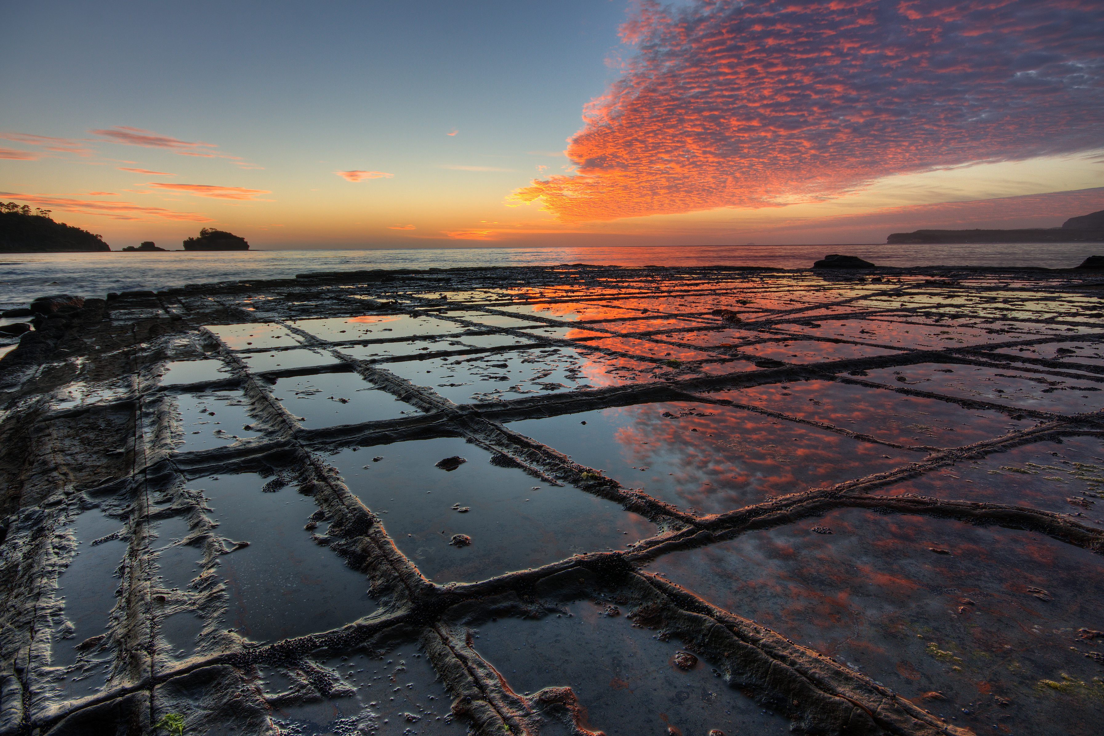
This image was selected as picture of the day on Wikimedia Commons for 19 July 2009. It was captioned as follows: English: Sunrise, Tessellated Pavement, Eaglehawk Neck, Tasman Peninsula, Tasmania, Australia. Other languages:
Čeština: Západ slunce nad přírodním mozaikovitým útvarem na šíji Eaglehawk Neck, ležící na australském ostrově Tasmánii English: Sunrise, Tessellated Pavement, Eaglehawk Neck, Tasman Peninsula, Tasmania, Australia. Español: Amanecer sobre el pavimento con forma de mosaico natural en Eaglehawk Neck, Tasmania, Australia. Français : Lever de soleil sur un pavement en mosaïque naturelle à Eaglehawk Neck, en Tasmanie (Australie). Italiano: Levar del Sole su un terreno a mosaico naturale a Eaglehawk Neck, nella penisola di Tasman, Tasmania (Australia). Magyar: Napfelkelte természetes négyszögletes képződmények fölött (Eaglehawk Neck, Tasmán félsziget, Tasmánia, Ausztrália) Malti: Tlugħ ix-xemx fuq art taħt forma ta' mużajk naturali f'Eaglehawk Neck, fit-Tażmanja (Awstralja). Nederlands: zonsopgang boven het tessellated pavement van de landengte Eaglehawk Neck van het Tasman-schiereiland aan zuidoostelijke zijde van het Australische eiland Tasmanië. Een tessellated pavement ("mozaïekterras") is een erosieverschijnsel in vlakgelegen sedimentair gesteente langs sommige oceanen, waarvan Eaglehawk Neck een bekend voorbeeld vormt. Polski: Wschód słońca i mozajkowy chodnik w Eaglehawk Neck, Półwysep Tasmański, Tasmania, Australia. Português: Amanhecer sobre o pavimento de mosaico natural em Eaglehawk Neck, península de Tasman, Austrália. Български: Изгрев над "Мозаечната настилка" на брега на Игълхоук Нек на полусотров Тасман, остров Тасмания, Австралия. Македонски: Изгрејсонце со природно „поплочен“ брег во Иглхок Нек на полуостровот Тасман во Тасманија, Австралија. فارسی : طلوع آفتاب، فرش موزاییکشکل، گردنهٔ ایگلهاوک، شبهجزیرهٔ تاسمان، تاسمانی، استرالیا. |
Summary
| DescriptionTessellated Pavement Sunrise Landscape.jpg |
English: Sunrise, “Tessellated Pavement”, Eaglehawk Neck, Tasman Peninsula, Tasmania, Australia. The „Tesselated Pavement“ is the result of an orthogonal joint pattern in the rock. On the picture it shows the so called “pan formation”, where the rock in the immediate vicinity of the joints is more resistant to erosion than the rock that is more distant to the joints, This is due to alterations of the rock along the joints by hydrothermal (or similar) solutions when the rock was still buried deeply below the surface millions of years ago. When no alterations or alterations that lower the erosional resistivity have taken place in the geological past, the rock along the joints will erode faster than the rock that is more distant to the joints. In that case the so called “loaf formation” of “Tessellated Pavement” will form.
Français : Lever de soleil sur un pavement en mosaïque naturel à Eaglehawk Neck, en Tasmanie (Australie).
Deutsch: Sonnenaufgang bei Ebbe am Eaglehawk Neck, Tasman-Halbinsel, Tasmanien, Australien. Das Gestein zeigt eine natürliche Parkettierung (Tesselation), die auf ein rechtwinkliges Klüftungsmuster im Gestein zurückgeht. Auf dem Foto äußert sie sich in Gestalt sogenannter „Beckenstrukturen“, bei der das Gestein in der unmittelbaren Umgebung der Klüfte erosionsresistenter ist, als das Gestein in größerer Entfernung zu den Klüften. Dies ist wiederum das Ergebnis einer Gesteinsumwandlung entlang der Klüfte durch hydrothermale (oder ähnliche) Lösungen, zu einer Zeit als das Gestein sich noch tief unterhalb der Erdoberfläche befand, vor Millionen von Jahren. Falls keine Umwandlungen stattgefunden haben oder Umwandlungen, die zu einer Herabsetzung der Erosionsresistenz führten, erodiert das Gestein entlang der Klüfte schneller als das Gestein in größerer Entfernung zu den Klüften und es bilden sich „Brotlaibstrukturen“ (im Deutschen auch als Wollsackverwitterung bezeichnet). |
|||
| Date | ||||
| Source | Own work | |||
| Author | JJ Harrison (https://www.jjharrison.com.au/) | |||
| Permission (Reusing this file) |
Own work, share alike, attribution required (Creative Commons CC-BY-SA-2.5) | |||
| Other versions |
|


| Camera location | 43° 00′ 33.53″ S, 147° 55′ 55.74″ E | View this and other nearby images on: OpenStreetMap |
|---|
- You are free:
- to share – to copy, distribute and transmit the work
- to remix – to adapt the work
- Under the following conditions:
- attribution – You must give appropriate credit, provide a link to the license, and indicate if changes were made. You may do so in any reasonable manner, but not in any way that suggests the licensor endorses you or your use.
- share alike – If you remix, transform, or build upon the material, you must distribute your contributions under the same or compatible license as the original.

|
This image has been assessed under the valued image criteria and is considered the most valued image on Commons within the scope: Tessellated Pavement Sunrise Landscape, Eaglehawk Neck, Tasmania. You can see its nomination here. |
Captions
28 January 2009
43°0'33.534"S, 147°55'55.740"E
2 second
9.93486
11 millimetre
100
image/jpeg
File history
Click on a date/time to view the file as it appeared at that time.
| Date/Time | Thumbnail | Dimensions | User | Comment | |
|---|---|---|---|---|---|
| current | 06:26, 2 December 2018 | | 3,587 × 2,391 (5.9 MB) | JJ Harrison | More pixels! |
| 00:55, 24 May 2009 |  | 1,782 × 1,170 (1.32 MB) | JJ Harrison | untilt | |
| 12:24, 28 January 2009 |  | 1,794 × 1,196 (1.38 MB) | JJ Harrison | {{Information |Description=Sunrise, Tessellated Pavement, Eaglehawk Neck, Tasman Peninsula, Tasmania, Australia |Source=Own work |Date=28/01/2009 |Author=Noodle snacks |Permission=Own work, share alike, attribution required (Creativ |
File usage
- Eaglehawk Neck
- Patterns in nature
- Tasman Peninsula
- Tasmania
- Tessellated pavement
- User:Corinne/subpage
- User:Fireblazex3
- User:JJ Harrison/gallery
- User:Mohamed CJ/backgroundgallery
- User:Shootbamboo
- User talk:Fir0002/Guild
- User talk:JJ Harrison/Archive1
- User talk:JJ Harrison/Archive3
- User talk:בינה תפארת
- Wikipedia:Featured picture candidates/February-2009
- Wikipedia:Featured picture candidates/File:Tessellated Pavement Sunrise Landscape.jpg
- Wikipedia:Featured pictures/Places/Landscapes
- Wikipedia:Featured pictures thumbs/15
- Wikipedia:Picture of the day/December 2009
- Wikipedia:WikiProject Australia/2.0/About
- Wikipedia:WikiProject Australia/Featured and good content
- Wikipedia:WikiProject Geology/Automated list of recognized content
- Wikipedia:WikiProject Geology/Recognized content
- Wikipedia:Wikipedia Signpost/2009-02-16/Features and admins
- Wikipedia:Wikipedia Signpost/2009-02-16/SPV
- Wikipedia:Wikipedia Signpost/Single/2009-02-16
- Template:POTD/2009-12-20
- Portal:Australia/Content
- Portal:Geography
- Portal:Geography/Featured picture
- Portal:Geography/Featured picture/2
- Portal:Geography/Featured picture/2010, week 52
- Portal:Geography/Featured picture archive/2010
Global file usage
The following other wikis use this file:
- Usage on ar.wikipedia.org
- Usage on bn.wikipedia.org
- Usage on bo.wikipedia.org
- Usage on crh.wikipedia.org
- Usage on cv.wikipedia.org
- Usage on da.wikipedia.org
- Usage on de.wikipedia.org
- Usage on de.wikivoyage.org
- Usage on el.wikipedia.org
- Usage on en.wikiversity.org
- Usage on en.wikivoyage.org
- Usage on eo.wikipedia.org
- Usage on es.wikipedia.org
- Usage on fa.wikipedia.org
- تنگه شاهین
- ویکیپدیا:نگارههای برگزیده/جاها/طبیعت
- درگاه:جغرافیا/نگارهٔ برگزیده
- درگاه:جغرافیا/نگارهٔ برگزیده/۲
- درگاه:دانش/نگارهٔ برگزیده
- درگاه:دانش/نگارهٔ برگزیده/۴
- ویکیپدیا:گزیدن نگاره برگزیده/اوت-۲۰۱۳
- ویکیپدیا:نگاره روز/ژانویه ۲۰۱۴
- بحث کاربر:Mahan/بایگانی ۱۴
- ویکیپدیا:گزیدن نگاره برگزیده/Tessellated Pavement Sunrise Landscape.jpg
- الگو:نر/2014-01-20
- الگو:نر محافظت شده/2014-01-20
- Usage on fr.wikipedia.org
- Usage on gn.wikipedia.org
- Usage on he.wikipedia.org
- Usage on hu.wikipedia.org
View more global usage of this file.
Metadata
This file contains additional information, probably added from the digital camera or scanner used to create or digitize it.
If the file has been modified from its original state, some details may not fully reflect the modified file.
| Camera model | Canon EOS 400D DIGITAL |
|---|---|
| Exposure time | 2/1 sec (2) |
| F-number | f/9.93486 |
| ISO speed rating | 100 |
| Date and time of data generation | 05:53, 28 January 2009 |
| Lens focal length | 11 mm |
| Width | 3,587 px |
| Height | 2,391 px |
| Bits per component |
|
| Compression scheme | Uncompressed |
| Pixel composition | RGB |
| Orientation | Normal |
| Number of components | 3 |
| Horizontal resolution | 3,036.9933 dpi |
| Vertical resolution | 3,036.9933 dpi |
| Data arrangement | chunky format |
| Software used | Adobe Photoshop CS4 Windows |
| File change date and time | 13:26, 21 February 2010 |
| Color space | Uncalibrated |
| Image width | 3,587 px |
| Image height | 2,391 px |
| Date and time of digitizing | 16:53, 28 January 2009 |
| Date metadata was last modified | 00:26, 22 February 2010 |
| Unique ID of original document | uuid:5386267DEEECDD11BDB29CAD2EEBB036 |