File:TAAF-CIA_WFB_Map.png
From Wikipedia, the free encyclopedia
Size of this preview: 466 × 599 pixels. Other resolutions: 187 × 240 pixels | 373 × 480 pixels | 690 × 887 pixels.
Original file (690 × 887 pixels, file size: 49 KB, MIME type: image/png)
| This is a file from the Wikimedia Commons. Information from its description page there is shown below. Commons is a freely licensed media file repository. You can help. |
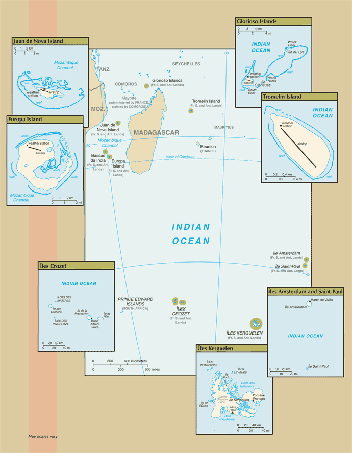
Map of the French Southern and Antarctic Lands, from CIA.gov
| Public domainPublic domainfalsefalse |
This image is in the public domain because it contains materials that originally came from the United States Central Intelligence Agency's World Factbook.
Bahasa Indonesia ∙ čeština ∙ Deutsch ∙ eesti ∙ English ∙ español ∙ Esperanto ∙ français ∙ galego ∙ hrvatski ∙ italiano ∙ Nederlands ∙ norsk nynorsk ∙ polski ∙ português ∙ sicilianu ∙ slovenščina ∙ suomi ∙ Türkçe ∙ Zazaki ∙ беларуская (тарашкевіца) ∙ македонски ∙ русский ∙ српски / srpski ∙ українська ∙ ქართული ∙ বাংলা ∙ தமிழ் ∙ മലയാളം ∙ 한국어 ∙ 日本語 ∙ 中文 ∙ 中文(简体) ∙ 中文(繁體) ∙ العربية ∙ +/− |
 |
Captions
r
Items portrayed in this file
depicts
File history
Click on a date/time to view the file as it appeared at that time.
| Date/Time | Thumbnail | Dimensions | User | Comment | |
|---|---|---|---|---|---|
| current | 10:14, 25 July 2007 | | 690 × 887 (49 KB) | Hoshie | Updated map of the French Southern and Antarctic Lands from the CIA World Factbook, 19 July 07 rev. Src: https://www.cia.gov/library/publications/the-world-factbook/maps/fs-map.gif |
| 09:12, 18 January 2006 |  | 328 × 352 (7 KB) | Hoshie | Map of the French Southern and Antarctic Lands, from [http://www.cia.gov/cia/publications/factbook/maps/fs-map.gif CIA.gov] {{PD-USGov-CIA-WF}} |
File usage
The following pages on the English Wikipedia use this file (pages on other projects are not listed):
Global file usage
The following other wikis use this file:
- Usage on af.wikipedia.org
- Usage on az.wikipedia.org
- Usage on be-tarask.wikipedia.org
- Usage on bn.wikipedia.org
- Usage on ca.wikipedia.org
- Usage on cy.wikipedia.org
- Usage on de.wikipedia.org
- Usage on eo.wikipedia.org
- Usage on es.wikipedia.org
- Usage on frr.wikipedia.org
- Usage on gl.wikipedia.org
- Usage on id.wikipedia.org
- Usage on it.wikipedia.org
- Usage on lv.wikipedia.org
- Usage on mk.wikipedia.org
- Usage on mt.wikipedia.org
- Usage on nds-nl.wikipedia.org
- Usage on nn.wikipedia.org
- Usage on ro.wikipedia.org
- Usage on war.wikipedia.org
- Usage on zh-yue.wikipedia.org
- Usage on zh.wikipedia.org
Retrieved from "https://en.wikipedia.org/wiki/File:TAAF-CIA_WFB_Map.png"