File:SerbiaPoliticalDivision.png
From Wikipedia, the free encyclopedia
Size of this preview: 472 × 600 pixels. Other resolutions: 189 × 240 pixels | 378 × 480 pixels | 604 × 768 pixels | 806 × 1,024 pixels | 1,565 × 1,988 pixels.
Original file (1,565 × 1,988 pixels, file size: 186 KB, MIME type: image/png)
| This is a file from the Wikimedia Commons. Information from its description page there is shown below. Commons is a freely licensed media file repository. You can help. |
Summary
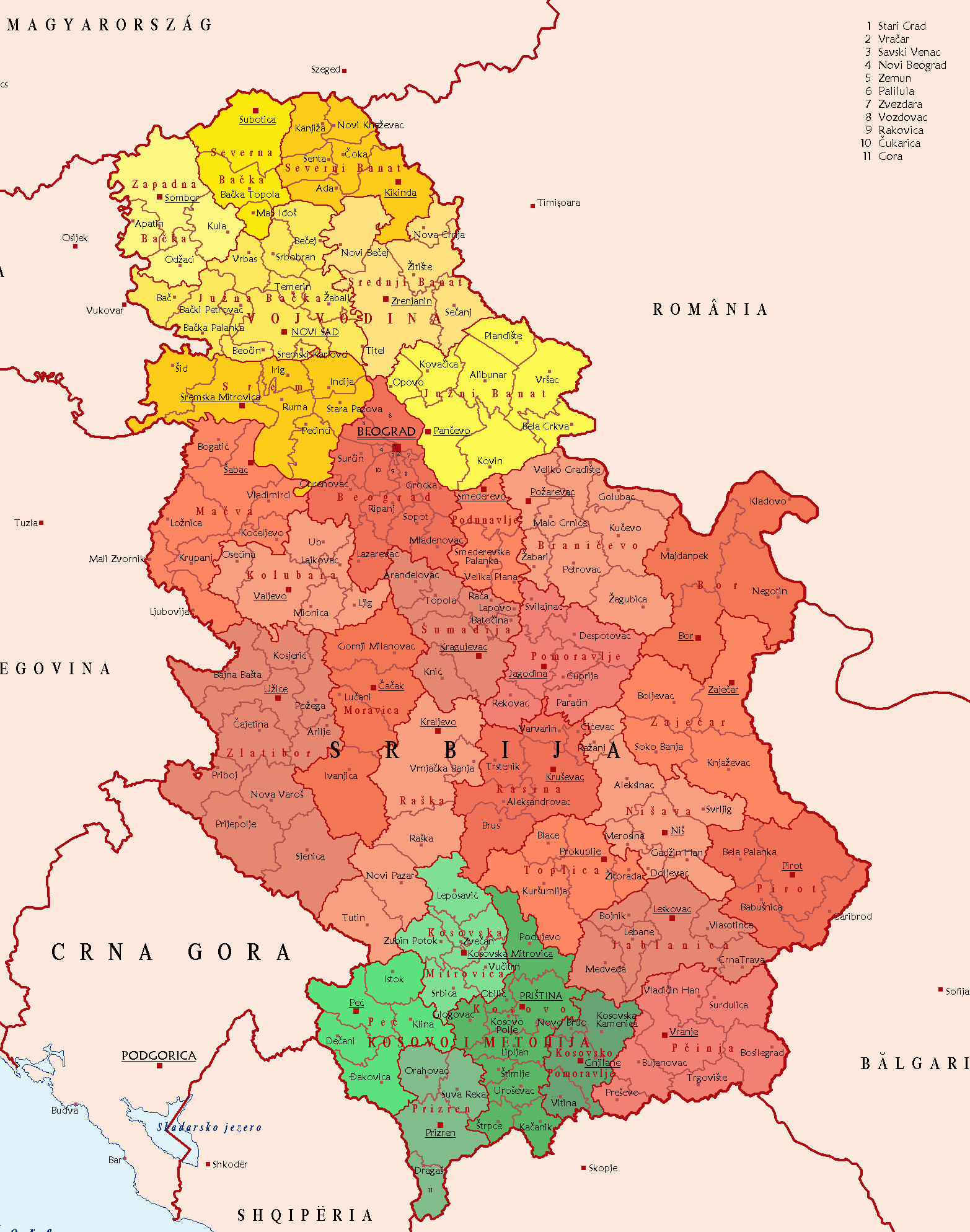
| DescriptionSerbiaPoliticalDivision.png |
English: Political Division of Serbia Deutsch: Politische Gliederung Serbiens Polski: Podział administracyjny Republiki Serbii . |
| Source | Taken from German Wikipedia: de:File:SCG Politische Gliederung2.png. |
| Author | CCGavranCC at the German Wikipedia |
| Other versions |
  .png) |
Licensing
| Public domainPublic domainfalsefalse |
| |
This work has been released into the public domain by its author, CCGavranCC, at the English Wikipedia project. This applies worldwide. In case this is not legally possible: |
Captions
Add a one-line explanation of what this file represents
Items portrayed in this file
depicts
File history
Click on a date/time to view the file as it appeared at that time.
| Date/Time | Thumbnail | Dimensions | User | Comment | |
|---|---|---|---|---|---|
| current | 04:44, 26 March 2018 | | 1,565 × 1,988 (186 KB) | Yann | Reverted to version as of 18:02, 15 June 2017 (UTC) |
| 14:32, 25 March 2018 |  | 1,565 × 1,988 (187 KB) | Hakuli | Reverted to version as of 17:00, 15 June 2017 (UTC) | |
| 18:02, 15 June 2017 |  | 1,565 × 1,988 (186 KB) | Кликери | Reverted to version as of 22:45, 27 January 2015 (UTC) | |
| 17:00, 15 June 2017 |  | 1,565 × 1,988 (187 KB) | Hakuli | Reverted to version as of 13:57, 22 January 2015 (UTC) | |
| 22:45, 27 January 2015 |  | 1,565 × 1,988 (186 KB) | Anastan | mapalready exist, File:Districts and Municipalities of Serbia (without Kosovo).png | |
| 14:59, 27 January 2015 |  | 1,565 × 1,988 (187 KB) | Mapclean | incorrect borders | |
| 19:23, 24 January 2015 |  | 1,565 × 1,988 (186 KB) | Anastan | upload new map, restore original | |
| 13:57, 22 January 2015 |  | 1,565 × 1,988 (187 KB) | Mapclean | Borders | |
| 21:46, 1 February 2014 |  | 1,565 × 1,988 (186 KB) | BokicaK | cropped | |
| 16:16, 5 June 2006 |  | 2,089 × 2,538 (300 KB) | Bjarki S | Taken from German Wikipedia: de:Bild:SCG Politische Gliederung2.png. In public domain. {{pd}} |
File usage
The following pages on the English Wikipedia use this file (pages on other projects are not listed):
Global file usage
The following other wikis use this file:
- Usage on ar.wikipedia.org
- Usage on ast.wikipedia.org
- Usage on be-tarask.wikipedia.org
- Usage on bg.wikipedia.org
- Usage on bn.wikipedia.org
- Usage on ca.wikipedia.org
- Usage on csb.wikipedia.org
- Usage on cs.wikipedia.org
- Usage on de.wikipedia.org
- Usage on es.wikipedia.org
- Usage on fr.wikipedia.org
- Usage on hr.wikipedia.org
- Usage on hu.wikipedia.org
- Usage on is.wikipedia.org
- Usage on ja.wikipedia.org
- Usage on ku.wikipedia.org
- Usage on lt.wikipedia.org
- Usage on pl.wikipedia.org
- Usage on pl.wikivoyage.org
- Usage on ro.wikipedia.org
- Usage on ru.wiktionary.org
- Usage on sco.wikipedia.org
- Usage on sh.wikipedia.org
- Usage on simple.wikipedia.org
- Usage on si.wikipedia.org
- Usage on sk.wikipedia.org
- Usage on sl.wikipedia.org
- Usage on sr.wikipedia.org
- Usage on trv.wikipedia.org
- Usage on uk.wikipedia.org
View more global usage of this file.
Metadata
This file contains additional information, probably added from the digital camera or scanner used to create or digitize it.
If the file has been modified from its original state, some details may not fully reflect the modified file.
| File change date and time | 17:42, 18 July 2007 |
|---|
Retrieved from "https://en.wikipedia.org/wiki/File:SerbiaPoliticalDivision.png"