File:Seattle_map_2.png
From Wikipedia, the free encyclopedia
Size of this preview: 354 × 600 pixels. Other resolutions: 141 × 240 pixels | 370 × 627 pixels.
Original file (370 × 627 pixels, file size: 89 KB, MIME type: image/png)
| This is a file from the Wikimedia Commons. Information from its description page there is shown below. Commons is a freely licensed media file repository. You can help. |
Summary
| DescriptionSeattle map 2.png |
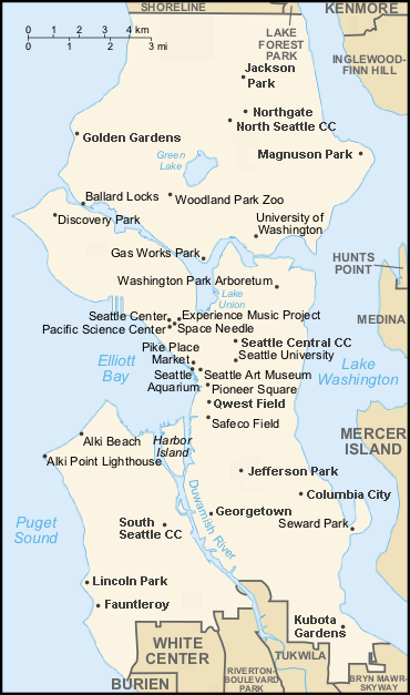
Map of Seattle. Based on map created by ShadowDragon, which was in turn based on maps from the U.S. Census Bureau's website and the CIA World Factbook's map style. More places labeled (mostly in the north and south ends of town). Updated "Seahawks Stadium" to "Qwest Field". Unfortunately, couldn't perfectly match fonts. |
| Date | |
| Source | Image:Seattle map.png enhanced and updated by Joe Mabel |
| Author | ShadowDragon, with enhancements by Joe Mabel |
| Permission (Reusing this file) |
GFDL |
| Other versions | Image:Seattle map.png |
Someone who can make an SVG should eventually replace this with an SVG.
Licensing

|
Permission is granted to copy, distribute and/or modify this document under the terms of the GNU Free Documentation License, Version 1.2 or any later version published by the Free Software Foundation; with no Invariant Sections, no Front-Cover Texts, and no Back-Cover Texts. A copy of the license is included in the section entitled GNU Free Documentation License.http://www.gnu.org/copyleft/fdl.htmlGFDLGNU Free Documentation Licensetruetrue |
| This file is licensed under the Creative Commons Attribution-Share Alike 3.0 Unported license. | ||
| ||
| This licensing tag was added to this file as part of the GFDL licensing update.http://creativecommons.org/licenses/by-sa/3.0/CC BY-SA 3.0Creative Commons Attribution-Share Alike 3.0truetrue |
Captions
Add a one-line explanation of what this file represents
Items portrayed in this file
depicts
December 2007
File history
Click on a date/time to view the file as it appeared at that time.
| Date/Time | Thumbnail | Dimensions | User | Comment | |
|---|---|---|---|---|---|
| current | 03:37, 21 March 2008 | | 370 × 627 (89 KB) | Jmabel | corrected spelling of "Magnuson" |
| 07:03, 20 December 2007 |  | 370 × 627 (91 KB) | Jmabel | {{Information |Description=Map of Seattle. Based on map created by ShadowDragon, which was in turn based on maps from the U.S. Census Bureau's website and the CIA World Factbook's map style. More places labeled (mostly |
File usage
The following pages on the English Wikipedia use this file (pages on other projects are not listed):
- Bikur Cholim Machzikay Hadath
- Congregation Ezra Bessaroth
- Dockside Cannabis Museum
- Kavana Cooperative
- Langston Hughes Performing Arts Institute
- Magnuson Park
- Matthews Beach Park
- Statue of Lenin (Seattle)
- Talk:Seattle/Archive 6
- Module:Location map/data/Seattle landmarks
- Module:Location map/data/Seattle landmarks/doc
Global file usage
The following other wikis use this file:
- Usage on es.wikipedia.org
- Usage on ja.wikipedia.org
- Usage on si.wikipedia.org
- Usage on uz.wikipedia.org
Retrieved from "https://en.wikipedia.org/wiki/File:Seattle_map_2.png"