File:Salt_ponds,_South_Bay,_SF.jpg
From Wikipedia, the free encyclopedia
Size of this preview: 521 × 600 pixels. Other resolutions: 208 × 240 pixels | 417 × 480 pixels | 667 × 768 pixels | 889 × 1,024 pixels | 2,376 × 2,736 pixels.
Original file (2,376 × 2,736 pixels, file size: 4.52 MB, MIME type: image/jpeg)
| This is a file from the Wikimedia Commons. Information from its description page there is shown below. Commons is a freely licensed media file repository. You can help. |
Summary
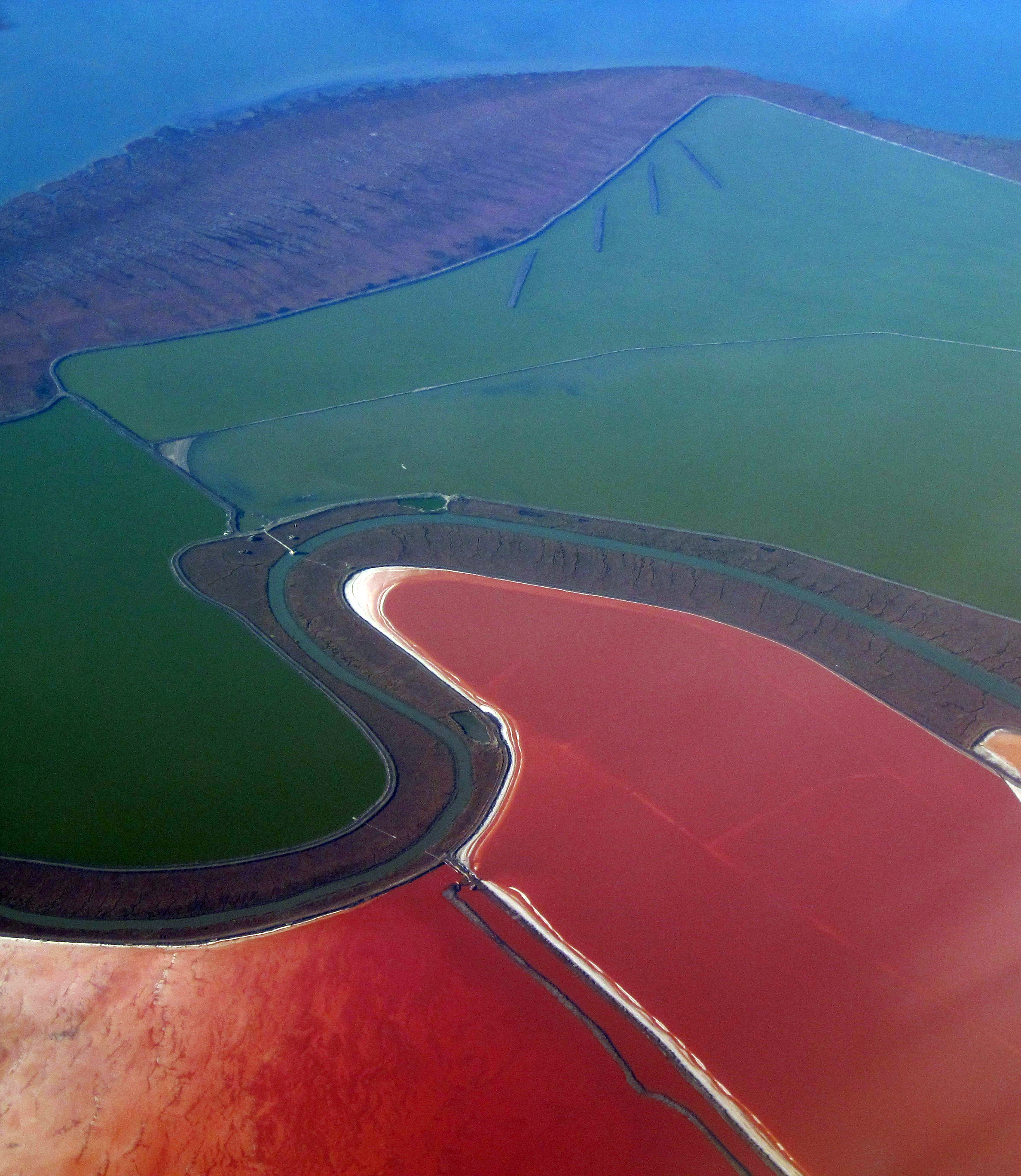
| DescriptionSalt ponds, South Bay, SF.jpg | High power electrical supply towers and lines cross salt ponds of the South Bay. Salt evaporation ponds formed by salt water impounded within levees in former tidelands on the shores of San Francisco Bay. There are many of these ponds surrounding the South Bay. As the water evaporates, micro-organisms of several kinds come to predominate and change the color of the water. First come green algae, then darkening as orange brine shrimp predominate. Finally red predominates as dunaliella salina, a micro-algae containing high amounts of beta-carotene (itself with high commercial value), predominates. Other organisms can also change the hue of each pond. Colors include red, green, orange and yellow, brown and blue. Finally, when the water is evaporated, the white of salt alone remains. This is harvested with machines, and the process repeats. |
| Date | |
| Source |
|
| Author | Doc Searls from Santa Barbara, USA |
| Object location | 37° 28′ 50.22″ N, 122° 01′ 28.46″ W | View this and other nearby images on: OpenStreetMap |
|---|
Licensing
This file is licensed under the Creative Commons Attribution-Share Alike 2.0 Generic license.
- You are free:
- to share – to copy, distribute and transmit the work
- to remix – to adapt the work
- Under the following conditions:
- attribution – You must give appropriate credit, provide a link to the license, and indicate if changes were made. You may do so in any reasonable manner, but not in any way that suggests the licensor endorses you or your use.
- share alike – If you remix, transform, or build upon the material, you must distribute your contributions under the same or compatible license as the original.
| This image, originally posted to Flickr, was reviewed on January 22, 2010 by the administrator or reviewer File Upload Bot (Magnus Manske), who confirmed that it was available on Flickr under the stated license on that date. |
Captions
Add a one-line explanation of what this file represents
Items portrayed in this file
depicts
some value
26 November 2009
37°28'50.225"N, 122°1'28.459"W
0.0025 second
11.614 millimetre
100
File history
Click on a date/time to view the file as it appeared at that time.
| Date/Time | Thumbnail | Dimensions | User | Comment | |
|---|---|---|---|---|---|
| current | 21:00, 22 January 2010 | | 2,376 × 2,736 (4.52 MB) | File Upload Bot (Magnus Manske) | {{Information |Description=High power electrical supply towers and lines crosss salt ponds of the South Bay. Salt evaporation ponds formed by salt water impounded within levees in former tidelands on the shores of San Francisco Bay. There are many of thes |
File usage
The following pages on the English Wikipedia use this file (pages on other projects are not listed):
Global file usage
The following other wikis use this file:
- Usage on de.wikipedia.org
- Usage on is.wikipedia.org
- Usage on it.wikipedia.org
- Usage on oc.wikipedia.org
- Usage on ru.wikipedia.org
- Usage on uk.wikipedia.org
- Usage on vi.wikipedia.org
- Usage on zh.wikipedia.org
Metadata
This file contains additional information, probably added from the digital camera or scanner used to create or digitize it.
If the file has been modified from its original state, some details may not fully reflect the modified file.
| Camera manufacturer | Canon |
|---|---|
| Camera model | Canon PowerShot SD1200 IS |
| Exposure time | 1/400 sec (0.0025) |
| F-number | f/4 |
| ISO speed rating | 100 |
| Date and time of data generation | 11:49, 26 November 2009 |
| Lens focal length | 11.614 mm |
| Orientation | Normal |
| Horizontal resolution | 180 dpi |
| Vertical resolution | 180 dpi |
| Software used | Adobe Photoshop CS3 Macintosh |
| File change date and time | 22:49, 26 November 2009 |
| Y and C positioning | Co-sited |
| Exif version | 2.21 |
| Date and time of digitizing | 11:49, 26 November 2009 |
| Image compression mode | 3 |
| Shutter speed | 8.65625 |
| APEX aperture | 4 |
| Exposure bias | 0 |
| Maximum land aperture | 4 APEX (f/4) |
| Metering mode | Pattern |
| Flash | Flash did not fire, auto mode |
| Color space | sRGB |
| Focal plane X resolution | 15,136.929460581 |
| Focal plane Y resolution | 15,116.022099448 |
| Focal plane resolution unit | inches |
| Sensing method | One-chip color area sensor |
| Custom image processing | Normal process |
| Exposure mode | Auto exposure |
| White balance | Auto white balance |
| Digital zoom ratio | 1 |
| Scene capture type | Standard |
Retrieved from "https://en.wikipedia.org/wiki/File:Salt_ponds,_South_Bay,_SF.jpg"