File:Pike_Nat_Forest_vicinity_map.jpg
From Wikipedia, the free encyclopedia
No higher resolution available.
Pike_Nat_Forest_vicinity_map.jpg (507 × 430 pixels, file size: 102 KB, MIME type: image/jpeg)
| This is a file from the Wikimedia Commons. Information from its description page there is shown below. Commons is a freely licensed media file repository. You can help. |
Summary
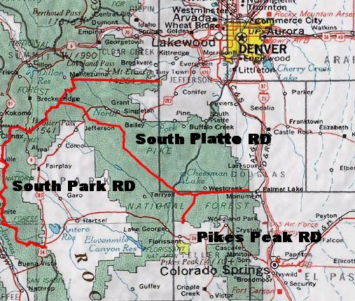
| DescriptionPike Nat Forest vicinity map.jpg |
English: Map of Pike National Forest (green areas).
|
| Date |
Unknown date Unknown date |
| Source | http://www.fs.fed.us/r2/psicc/maps/pike_vicinity.jpg |
| Author | USDA |
Licensing
| Public domainPublic domainfalsefalse |
This image is a work of the Forest Service of the United States Department of Agriculture. As a work of the U.S. federal government, the image is in the public domain.
|
File history
Click on a date/time to view the file as it appeared at that time.
| Date/Time | Thumbnail | Dimensions | User | Comment | |
|---|---|---|---|---|---|
| current | 21:55, 23 July 2007 | | 507 × 430 (102 KB) | Ken g6 | A map of the Pike National Forest. Sourced from [http://www.fs.fed.us/r2/psicc/maps/pike_vicinity.jpg this image], the picture was found on [http://www.fs.fed.us/r2/psicc/maps/pike.shtml this U.S.D.A. Forest Service web site]. |
File usage
The following pages on the English Wikipedia use this file (pages on other projects are not listed):
Global file usage
The following other wikis use this file:
- Usage on de.wikipedia.org
- Usage on es.wikipedia.org
- Usage on fa.wikipedia.org
- Usage on www.wikidata.org
Metadata
This file contains additional information, probably added from the digital camera or scanner used to create or digitize it.
If the file has been modified from its original state, some details may not fully reflect the modified file.
| _error | 0 |
|---|
Retrieved from "https://en.wikipedia.org/wiki/File:Pike_Nat_Forest_vicinity_map.jpg"