File:POLSKA_woj_pow_gminy.png
From Wikipedia, the free encyclopedia
Size of this preview: 646 × 600 pixels. Other resolutions: 259 × 240 pixels | 517 × 480 pixels | 827 × 768 pixels | 1,103 × 1,024 pixels | 2,041 × 1,895 pixels.
Original file (2,041 × 1,895 pixels, file size: 1.6 MB, MIME type: image/png)
| This is a file from the Wikimedia Commons. Information from its description page there is shown below. Commons is a freely licensed media file repository. You can help. |

|
This locator map image could be re-created using vector graphics as an SVG file. This has several advantages; see Commons:Media for cleanup for more information. If an SVG form of this image is available, please upload it and afterwards replace this template with
{{vector version available|new image name}}.
It is recommended to name the SVG file “POLSKA woj pow gminy.svg”—then the template Vector version available (or Vva) does not need the new image name parameter. |
Summary
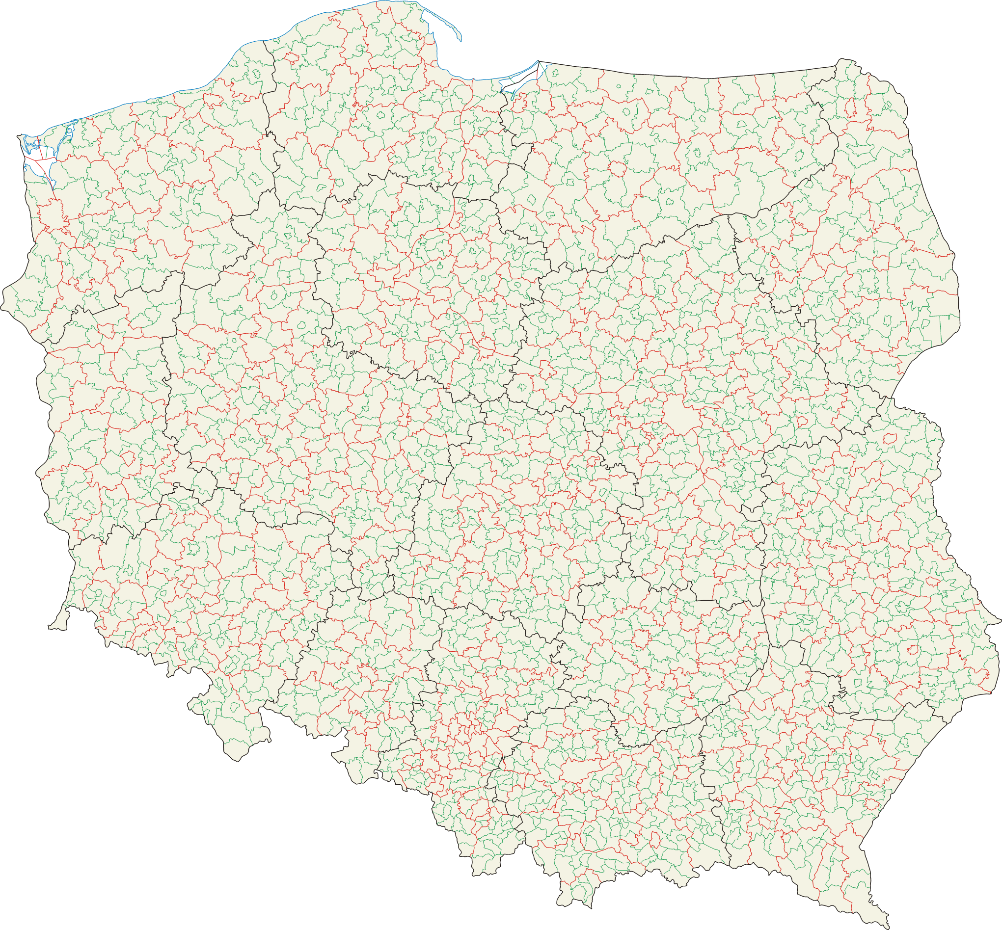
| DescriptionPOLSKA woj pow gminy.png |
Polski: Mapa administracyjna Polski z zaznaczonymi granicami województw (na czarno), powiatów (na czerwono) i gmin (na zielono), stan na 1 stycznia 2008 English: Administrative map of Poland with borders of voievodships (black), counties (red) and communes (green), as of January 1, 2008 |
||||||||
| Date | 2007-02-01, updated=2008-04-10 | ||||||||
| Source | Self-made, based on Administrative Map of Poland 1:500,000 published by Head Office of Geodesy and Cartography with actualization | ||||||||
| Author | Aotearoa | ||||||||
| Permission (Reusing this file) |
I, the copyright holder of this work, hereby publish it under the following licenses:
This file is licensed under the Creative Commons Attribution 2.5 Generic license.
You may select the license of your choice. |

Captions
Add a one-line explanation of what this file represents
Административная карта Польши с границами воеводств (чёрным), повятов (красным) и гмин (зелёным) на 1 Января 2008 года.
Items portrayed in this file
depicts
File history
Click on a date/time to view the file as it appeared at that time.
| Date/Time | Thumbnail | Dimensions | User | Comment | |
|---|---|---|---|---|---|
| current | 17:36, 25 January 2016 | | 2,041 × 1,895 (1.6 MB) | Aotearoa | drobna korekta (uzupełnienie przerwanych granic) |
| 14:41, 21 March 2015 |  | 2,041 × 1,895 (1.71 MB) | Aotearoa | Mapa przedstawia stan na 2008 rok, a wtedy Wałbrzych nie był wydzielony | |
| 14:18, 20 March 2015 |  | 2,041 × 1,895 (1.69 MB) | Blackfish | Wałbrzych | |
| 10:12, 19 May 2009 |  | 2,041 × 1,895 (1.71 MB) | Aotearoa | drobna korekta | |
| 07:20, 10 April 2008 |  | 2,041 × 1,895 (1.6 MB) | Aotearoa | ||
| 20:35, 5 February 2007 |  | 2,041 × 1,895 (1.71 MB) | Aotearoa | ||
| 18:34, 5 February 2007 |  | 2,041 × 1,895 (1.73 MB) | Aotearoa | Mapa administracyjna Polski z zaznaczonymi granicami województw, gmin i powiatów. Autor: Aotearoa<br> Administrative map of Poland with borders of województwa (voivodships), powiaty (counties) and gminy (communes). By [[User:Aotearoa| |
File usage
The following pages on the English Wikipedia use this file (pages on other projects are not listed):
Global file usage
The following other wikis use this file:
- Usage on ar.wikipedia.org
- Usage on bar.wikipedia.org
- Usage on be-tarask.wikipedia.org
- Usage on be.wikipedia.org
- Usage on bxr.wikipedia.org
- Usage on de.wikipedia.org
- Usage on eo.wikipedia.org
- Usage on et.wikipedia.org
- Usage on fr.wikipedia.org
- Usage on hu.wikipedia.org
- Usage on hy.wikipedia.org
- Usage on ky.wikipedia.org
- Usage on ltg.wikipedia.org
- Usage on lt.wikipedia.org
- Usage on lv.wikipedia.org
- Usage on pl.wikipedia.org
- Usage on pt.wikipedia.org
- Usage on ru.wikipedia.org
- Usage on xmf.wikipedia.org
Metadata
This file contains additional information, probably added from the digital camera or scanner used to create or digitize it.
If the file has been modified from its original state, some details may not fully reflect the modified file.
| PNG file comment | |
|---|---|
| Horizontal resolution | 118.11 dpc |
| Vertical resolution | 118.11 dpc |
Retrieved from "https://en.wikipedia.org/wiki/File:POLSKA_woj_pow_gminy.png"