File:Old_Kingston,_Alabama_EF3_damage_January_2023.jpg
From Wikipedia, the free encyclopedia
Size of this preview: 800 × 450 pixels. Other resolutions: 320 × 180 pixels | 640 × 360 pixels | 1,024 × 576 pixels | 1,280 × 720 pixels | 2,560 × 1,440 pixels | 4,032 × 2,268 pixels.
Original file (4,032 × 2,268 pixels, file size: 1.47 MB, MIME type: image/jpeg)
| This is a file from the Wikimedia Commons. Information from its description page there is shown below. Commons is a freely licensed media file repository. You can help. |
Summary
| DescriptionOld Kingston, Alabama EF3 damage January 2023.jpg |
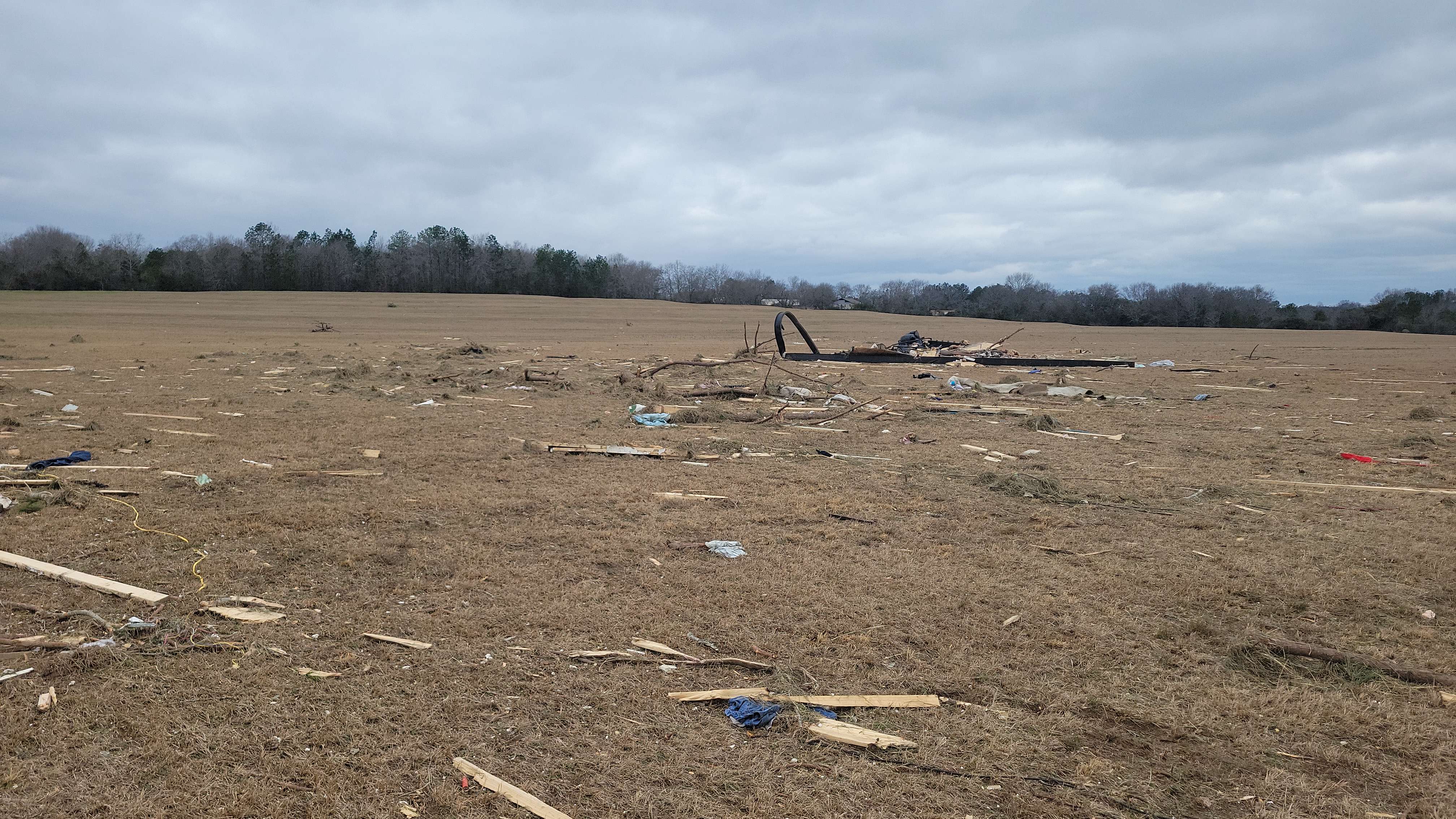
English: The frame of a mobile home that was completely obliterated by an EF3 tornado in Old Kingston, Alabama. "Frame of manufactured home thrown 250 yards landed here." |
| Date | |
| Source | https://services.dat.noaa.gov/arcgis/rest/services/nws_damageassessmenttoolkit/DamageViewer/FeatureServer/0/3394751/attachments/2070046 |
| Author | National Weather Service Birmingham AL |
| Camera location | 32° 34′ 59.33″ N, 86° 36′ 18.36″ W | View this and other nearby images on: OpenStreetMap |
|---|
Licensing
| Public domainPublic domainfalsefalse |
This image is in the public domain because it contains materials that originally came from the U.S. National Oceanic and Atmospheric Administration, taken or made as part of an employee's official duties.
العربية ∙ čeština ∙ Deutsch ∙ Zazaki ∙ English ∙ español ∙ eesti ∙ suomi ∙ français ∙ hrvatski ∙ magyar ∙ italiano ∙ 日本語 ∙ 한국어 ∙ македонски ∙ മലയാളം ∙ Plattdüütsch ∙ Nederlands ∙ polski ∙ português ∙ română ∙ русский ∙ sicilianu ∙ slovenščina ∙ Türkçe ∙ Tiếng Việt ∙ 简体中文 ∙ 繁體中文 ∙ +/− |
Captions
The frame of a mobile home that was completely obliterated by an EF3 tornado in Old Kingston, Alabama.
Items portrayed in this file
depicts
image/jpeg
893a0bdefb962b8b0544eb27528860faf45dbebe
1,541,576 byte
2,268 pixel
4,032 pixel
32°34'59.333"N, 86°36'18.360"W
0.000929737 second
1.8
5.4 millimetre
File history
Click on a date/time to view the file as it appeared at that time.
| Date/Time | Thumbnail | Dimensions | User | Comment | |
|---|---|---|---|---|---|
| current | 01:44, 16 January 2023 | | 4,032 × 2,268 (1.47 MB) | ChessEric | Uploaded a work by National Weather Service Birmingham AL from https://services.dat.noaa.gov/arcgis/rest/services/nws_damageassessmenttoolkit/DamageViewer/FeatureServer/0/3394751/attachments/2070046 with UploadWizard |
File usage
The following pages on the English Wikipedia use this file (pages on other projects are not listed):
Metadata
This file contains additional information, probably added from the digital camera or scanner used to create or digitize it.
If the file has been modified from its original state, some details may not fully reflect the modified file.
| Camera manufacturer | samsung |
|---|---|
| Camera model | SM-G991U |
| Exposure time | 929,737/1,000,000,000 sec (0.000929737) |
| F-number | f/1.8 |
| ISO speed rating | 50 |
| Date and time of data generation | 12:26, 13 January 2023 |
| Lens focal length | 5.4 mm |
| Latitude | 32° 34′ 59.33″ N |
| Longitude | 86° 36′ 18.36″ W |
| Altitude | 100.515 meters above sea level |
| Width | 4,032 px |
| Height | 2,268 px |
| Orientation | Normal |
| Horizontal resolution | 72 dpi |
| Vertical resolution | 72 dpi |
| Software used | ArcGIS Survey123 |
| File change date and time | 12:26, 13 January 2023 |
| Y and C positioning | Centered |
| Exposure Program | Normal program |
| Exif version | 3.2 |
| Date and time of digitizing | 12:26, 13 January 2023 |
| Meaning of each component |
|
| Shutter speed | 10.07 |
| APEX aperture | 1.69 |
| APEX brightness | 8.12 |
| Exposure bias | 0 |
| Maximum land aperture | 1.69 APEX (f/1.8) |
| Metering mode | Center weighted average |
| Flash | Flash did not fire |
| DateTime subseconds | 243385 |
| DateTimeOriginal subseconds | 243385 |
| DateTimeDigitized subseconds | 243385 |
| Supported Flashpix version | 1 |
| Color space | sRGB |
| Sensing method | Undefined |
| Scene type | A directly photographed image |
| Exposure mode | Auto exposure |
| White balance | Auto white balance |
| Focal length in 35 mm film | 26 mm |
| Scene capture type | Standard |
| GPS time (atomic clock) | 00:00 |
| Reference for direction of image | Magnetic direction |
| Direction of image | 214.97 |
| Geodetic survey data used | WGS-84 |
| GPS date | 2023-01-13 |
| GPS tag version | 2.3.0.0 |