File:Oakham_Market_Place_(geograph_7627324).jpg
From Wikipedia, the free encyclopedia
Size of this preview: 800 × 570 pixels. Other resolutions: 320 × 228 pixels | 640 × 456 pixels | 1,024 × 729 pixels.
Original file (1,024 × 729 pixels, file size: 956 KB, MIME type: image/jpeg)
| This is a file from the Wikimedia Commons. Information from its description page there is shown below. Commons is a freely licensed media file repository. You can help. |
Summary
| DescriptionOakham Market Place (geograph 7627324).jpg |
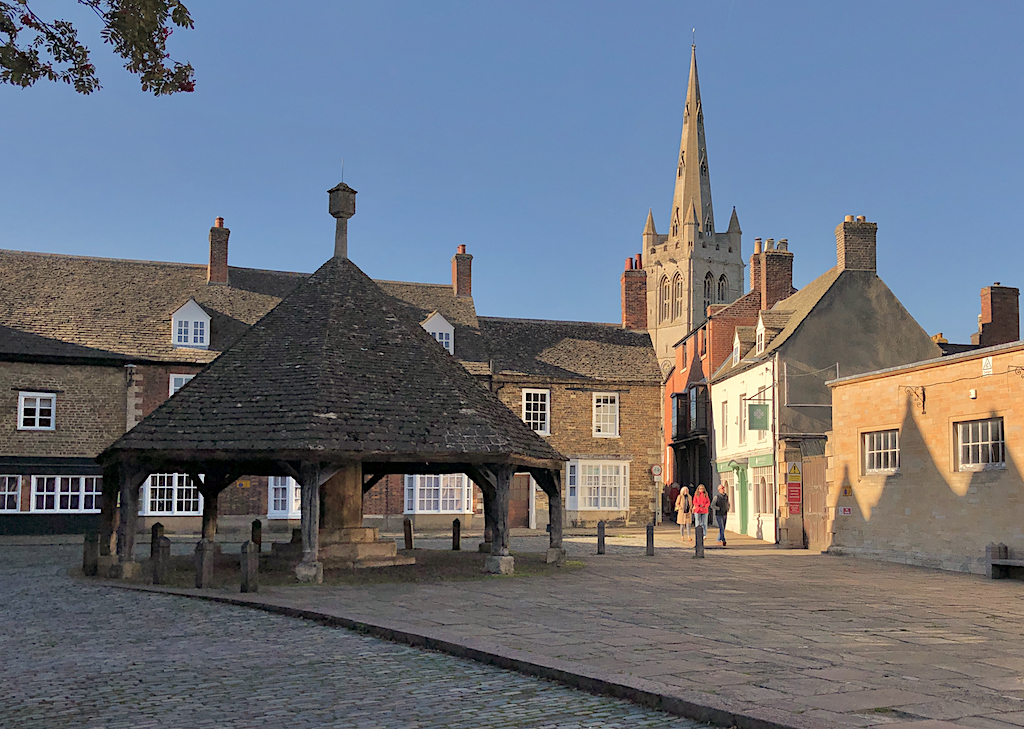
English: With the Buttercross to the left and the spire of All Saints Church to the right |
| Date | |
| Source | From geograph.org.uk |
| Author | Paul Harrop |
| Permission (Reusing this file) |
Creative Commons Attribution Share-alike license 2.0 |
| Attribution (required by the license) InfoField | Paul Harrop / Oakham Market Place / |
InfoField | Paul Harrop / Oakham Market Place |
| Camera location | 52° 40′ 13.15″ N, 0° 43′ 40.2″ W | View this and other nearby images on: OpenStreetMap |
|---|
| Object location | 52° 40′ 13.6″ N, 0° 43′ 41″ W | View this and other nearby images on: OpenStreetMap |
|---|
Licensing

|
This image was taken from the Geograph project collection. See this photograph's page on the Geograph website for the photographer's contact details. The copyright on this image is owned by Paul Harrop and is licensed for reuse under the Creative Commons Attribution-ShareAlike 2.0 license.
|
This file is licensed under the Creative Commons Attribution-Share Alike 2.0 Generic license.
Attribution: Paul Harrop
- You are free:
- to share – to copy, distribute and transmit the work
- to remix – to adapt the work
- Under the following conditions:
- attribution – You must give appropriate credit, provide a link to the license, and indicate if changes were made. You may do so in any reasonable manner, but not in any way that suggests the licensor endorses you or your use.
- share alike – If you remix, transform, or build upon the material, you must distribute your contributions under the same or compatible license as the original.
Captions
Add a one-line explanation of what this file represents
Items portrayed in this file
depicts
15 October 2023
52°40'13.152"N, 0°43'40.213"W
52°40'13.58"N, 0°43'41.38"W
0.00043706293706293706 second
1.8
3.99 millimetre
image/jpeg
File history
Click on a date/time to view the file as it appeared at that time.
| Date/Time | Thumbnail | Dimensions | User | Comment | |
|---|---|---|---|---|---|
| current | 15:21, 11 December 2023 | | 1,024 × 729 (956 KB) | Chocolateediter | == {{int:filedesc}} == {{Information |Description={{en|1= With the Buttercross to the left and the spire of All Saints Church to the right}} |Source=From [https://www.geograph.org.uk/photo/7627324 geograph.org.uk] |Date=2023-10-15 |Author=[https://www.geograph.org.uk/profile/13364 Paul Harrop] |Permission=Creative Commons Attribution Share-alike license 2.0 |Other fields={{Credit line |Author=Paul Harrop |License=[https://creativecommons.org/licenses/by-sa/2.0/ CC BY-SA 2.0] |Other=''Oakha... |
File usage
The following pages on the English Wikipedia use this file (pages on other projects are not listed):
Global file usage
The following other wikis use this file:
Metadata
This file contains additional information, probably added from the digital camera or scanner used to create or digitize it.
If the file has been modified from its original state, some details may not fully reflect the modified file.
| Exposure time | 1/2,288 sec (0.00043706293706294) |
|---|---|
| F-number | f/1.8 |
| ISO speed rating | 20 |
| Date and time of data generation | 15:09, 15 October 2023 |
| Lens focal length | 3.99 mm |
| Latitude | 52° 40′ 13.18″ N |
| Longitude | 0° 43′ 40.18″ W |
| Altitude | 109.021 meters above sea level |
| Pixel composition | RGB |
| Orientation | Normal |
| Horizontal resolution | 72 dpi |
| Vertical resolution | 72 dpi |
| Exposure Program | Normal program |
| Exif version | 2.32 |
| Date and time of digitizing | 15:09, 15 October 2023 |
| Meaning of each component |
|
| Shutter speed | 11.160079100235 |
| APEX aperture | 1.6959938128384 |
| APEX brightness | 10.079644685336 |
| Exposure bias | 0 |
| Metering mode | Spot |
| Flash | Flash did not fire, compulsory flash suppression |
| DateTime subseconds | 711 |
| DateTimeOriginal subseconds | 711 |
| DateTimeDigitized subseconds | 711 |
| Supported Flashpix version | 1 |
| Color space | sRGB |
| Sensing method | One-chip color area sensor |
| Scene type | A directly photographed image |
| Exposure mode | Auto exposure |
| White balance | Auto white balance |
| Focal length in 35 mm film | 28 mm |
| Scene capture type | Standard |
| Speed unit | Kilometers per hour |
| Speed of GPS receiver | 0.015563167620679 |
| Reference for direction of image | True direction |
| Direction of image | 322.67942857143 |
| Reference for bearing of destination | True direction |
| Bearing of destination | 322.67942857143 |
| IIM version | 2 |
.jpg)