File:Northwest-territory-usa-1787.png
From Wikipedia, the free encyclopedia
No higher resolution available.
Northwest-territory-usa-1787.png (349 × 276 pixels, file size: 61 KB, MIME type: image/png)
| This is a file from the Wikimedia Commons. Information from its description page there is shown below. Commons is a freely licensed media file repository. You can help. |
Summary

|
File:Northwest Territory locator map (1787).svg is a vector version of this file. It should be used in place of this PNG file when not inferior.
File:Northwest-territory-usa-1787.png → File:Northwest Territory locator map (1787).svg
For more information, see Help:SVG.
|
.svg) |
Licensing
| This file is licensed under the Creative Commons Attribution-Share Alike 3.0 Unported license. Subject to disclaimers. | ||
| ||
| This licensing tag was added to this file as part of the GFDL licensing update.http://creativecommons.org/licenses/by-sa/3.0/CC BY-SA 3.0Creative Commons Attribution-Share Alike 3.0truetrue |

|
Permission is granted to copy, distribute and/or modify this document under the terms of the GNU Free Documentation License, Version 1.2 or any later version published by the Free Software Foundation; with no Invariant Sections, no Front-Cover Texts, and no Back-Cover Texts. A copy of the license is included in the section entitled GNU Free Documentation License. Subject to disclaimers.http://www.gnu.org/copyleft/fdl.htmlGFDLGNU Free Documentation Licensetruetrue |
Captions
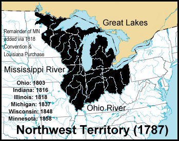
Map of the Northwest Territory as of 1787
Items portrayed in this file
depicts
File history
Click on a date/time to view the file as it appeared at that time.
| Date/Time | Thumbnail | Dimensions | User | Comment | |
|---|---|---|---|---|---|
| current | 04:05, 8 October 2006 | | 349 × 276 (61 KB) | Yassie | w:en:Image:Northwest-territory-usa-1787.png by Jengod, 10/13/2004 22:33 (UTC) |
File usage
The following pages on the English Wikipedia use this file (pages on other projects are not listed):
- History of slavery in Indiana
- Midwestern United States
- Northwest Ordinance
- Northwest Territory's at-large congressional district
- Organic act
- Polly Strong
- Samuel Brady
- Squatting in the United States
- Surveyor General of the Northwest Territory
- Treaty of Fort Harmar
- User:Notuncurious/Working/tmp7
- Wikipedia:Graphics Lab/Map workshop/Archive/Apr 2023
- Template:Infobox former subdivision/testcases
Global file usage
The following other wikis use this file:
- Usage on ar.wikipedia.org
- Usage on ca.wikipedia.org
- Usage on cs.wikipedia.org
- Usage on da.wikipedia.org
- Usage on de.wikipedia.org
- Usage on es.wikipedia.org
- Usage on fa.wikipedia.org
- Usage on fi.wikipedia.org
- Usage on gl.wikipedia.org
- Usage on he.wikipedia.org
- Usage on hi.wikipedia.org
- Usage on hu.wikipedia.org
- Usage on it.wikipedia.org
- Usage on ja.wikipedia.org
- Usage on ko.wikipedia.org
- Usage on lt.wikipedia.org
- Usage on ms.wikipedia.org
- Usage on mt.wikipedia.org
- Usage on nl.wikipedia.org
- Usage on pt.wikipedia.org
- Usage on ro.wikipedia.org
- Usage on ru.wikipedia.org
- Usage on sh.wikipedia.org
- Usage on simple.wikipedia.org
- Usage on sl.wikipedia.org
- Usage on sv.wikipedia.org
- Usage on tr.wikipedia.org
- Usage on ur.wikipedia.org
- Usage on vi.wikipedia.org
- Usage on zh.wikipedia.org
Retrieved from "https://en.wikipedia.org/wiki/File:Northwest-territory-usa-1787.png"