File:Normanton_Church,_Rutland_Water_-_geograph.org.uk_-_1462172.jpg
From Wikipedia, the free encyclopedia
No higher resolution available.
Normanton_Church,_Rutland_Water_-_geograph.org.uk_-_1462172.jpg (640 × 480 pixels, file size: 76 KB, MIME type: image/jpeg)
| This is a file from the Wikimedia Commons. Information from its description page there is shown below. Commons is a freely licensed media file repository. You can help. |
Summary
| DescriptionNormanton Church, Rutland Water - geograph.org.uk - 1462172.jpg |
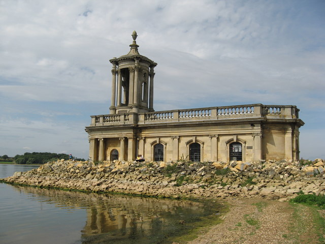
English: Normanton Church, Rutland Water. This is one of Rutland Water's most famous landmarks. The church, with semi-circular portico and tower, was built in 1826–9 and was designed by Thomas Cundy, then architect to the Grosvenor estate in Westminster.
The original site of Normanton Church (St Matthew's Church as it was once known) would have placed it below the proposed water line of Rutland Water. The Church was saved from the water and now houses an exhibition about the building of the reservoir, as well as fossils and an Anglo-Saxon skeleton. |
| Date | |
| Source | From geograph.org.uk |
| Author | Richard Rogerson |
| Attribution (required by the license) InfoField | Richard Rogerson / Normanton Church, Rutland Water / |
InfoField | Richard Rogerson / Normanton Church, Rutland Water |
| Camera location | 52° 38′ 45″ N, 0° 37′ 23″ W | View this and other nearby images on: OpenStreetMap |
|---|
| Object location | 52° 38′ 46″ N, 0° 37′ 23″ W | View this and other nearby images on: OpenStreetMap |
|---|
Licensing

|
This image was taken from the Geograph project collection. See this photograph's page on the Geograph website for the photographer's contact details. The copyright on this image is owned by Richard Rogerson and is licensed for reuse under the Creative Commons Attribution-ShareAlike 2.0 license.
|
This file is licensed under the Creative Commons Attribution-Share Alike 2.0 Generic license.
Attribution: Richard Rogerson
- You are free:
- to share – to copy, distribute and transmit the work
- to remix – to adapt the work
- Under the following conditions:
- attribution – You must give appropriate credit, provide a link to the license, and indicate if changes were made. You may do so in any reasonable manner, but not in any way that suggests the licensor endorses you or your use.
- share alike – If you remix, transform, or build upon the material, you must distribute your contributions under the same or compatible license as the original.
Captions
St Matthew's Church, Normanton
Items portrayed in this file
depicts
some value
52°38'44.74"N, 0°37'22.80"W
6 August 2009
52°38'46.36"N, 0°37'23.16"W
image/jpeg
File history
Click on a date/time to view the file as it appeared at that time.
| Date/Time | Thumbnail | Dimensions | User | Comment | |
|---|---|---|---|---|---|
| current | 09:06, 2 March 2011 | | 640 × 480 (76 KB) | GeographBot | == {{int:filedesc}} == {{Information |description={{en|1=Normanton Church, Rutland Water This is one of Rutland Waters's most famous landmarks. The church, with semi-circular portico and tower, was built in 1826-9 and was designed by Thomas Cundy, then ar |
File usage
The following pages on the English Wikipedia use this file (pages on other projects are not listed):
Metadata
This file contains additional information, probably added from the digital camera or scanner used to create or digitize it.
If the file has been modified from its original state, some details may not fully reflect the modified file.
| _error | 0 |
|---|