File:Nor'easter_1960-12-12_weather_map.jpg
From Wikipedia, the free encyclopedia
Size of this preview: 619 × 599 pixels. Other resolutions: 248 × 240 pixels | 496 × 480 pixels | 755 × 731 pixels.
Original file (755 × 731 pixels, file size: 592 KB, MIME type: image/jpeg)
| This is a file from the Wikimedia Commons. Information from its description page there is shown below. Commons is a freely licensed media file repository. You can help. |
Summary
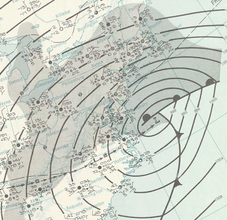
| DescriptionNor'easter 1960-12-12 weather map.jpg |
English: Surface weather analysis of the December 1960 nor'easter on December 12, 1960, while located off the coast of the Northeastern United States. |
||||
| Date | |||||
| Source | http://www.lib.noaa.gov/collections/imgdocmaps/daily_weather_maps.html | ||||
| Author | NOAA Central Library Data Imaging Project | ||||
| Permission (Reusing this file) |
|
Captions
Add a one-line explanation of what this file represents
Items portrayed in this file
depicts
12 December 1960
File history
Click on a date/time to view the file as it appeared at that time.
| Date/Time | Thumbnail | Dimensions | User | Comment | |
|---|---|---|---|---|---|
| current | 03:14, 28 April 2015 | | 755 × 731 (592 KB) | Juliancolton | {{Information |Description ={{en|1=Surface weather analysis of the {{w|December 1960 nor'easter}} on December 12, 1960, while located off the coast of the Northeastern United States.}} |Source =http://www.lib.noaa.gov/collections/imgdocmaps/... |
File usage
The following pages on the English Wikipedia use this file (pages on other projects are not listed):
Metadata
This file contains additional information, probably added from the digital camera or scanner used to create or digitize it.
If the file has been modified from its original state, some details may not fully reflect the modified file.
| JPEG file comment | Created with GIMP |
|---|