File:Naktong_Defense.jpg
From Wikipedia, the free encyclopedia
Original file (587 × 945 pixels, file size: 427 KB, MIME type: image/jpeg)
| This is a file from the Wikimedia Commons. Information from its description page there is shown below. Commons is a freely licensed media file repository. You can help. |
Summary
| DescriptionNaktong Defense.jpg |
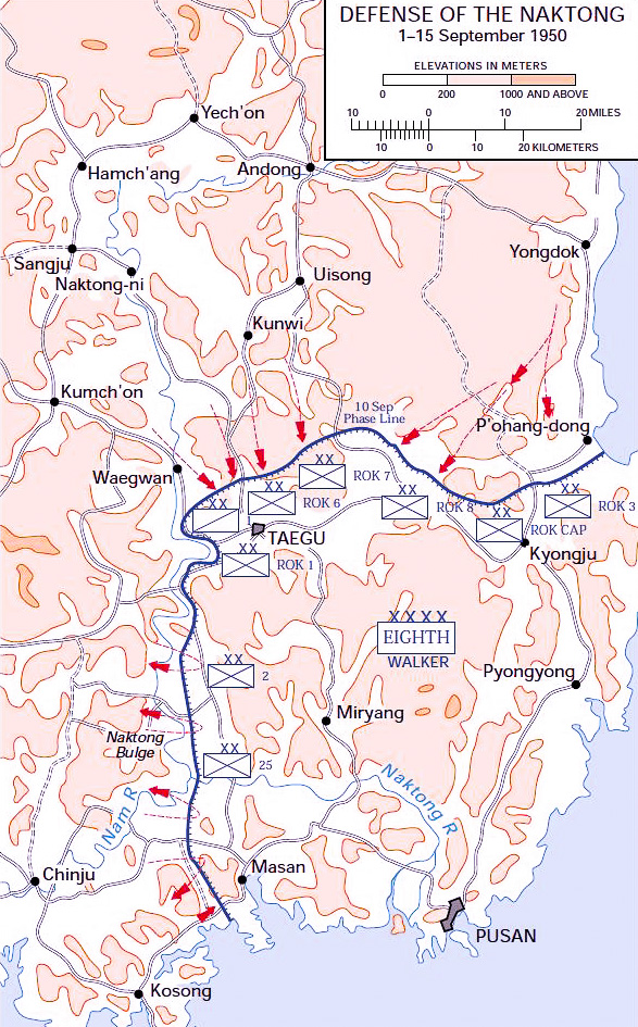
English: Map of the Naktong Defense lines, September 1950. This map was created by the United States Army Center of Military History (USACMH) and used in the brochure "The Korean War: The Outbreak" located at [1]. |
| Date | 27 December 2006 (original upload date) |
| Source | Transferred from en.wikipedia to Commons. |
| Author | The original uploader was Wbfergus at English Wikipedia. |
| Other versions |
|
.jpg)
.jpg)
.jpg)
.jpg)
.jpg)
Original upload log
- 2006-12-27 13:30 Wbfergus 350×572×8 (48792 bytes) Map of the Naktong Defense lines, September 1950. This map was created by the Center for Military History and used in the brochure "The Korean War: The Outbreak" located at [2].
Licensing
| Public domainPublic domainfalsefalse |
This file is a work of a U.S. Army soldier or employee, taken or made as part of that person's official duties. As a work of the U.S. federal government, it is in the public domain in the United States.
العربية ∙ বাংলা ∙ català ∙ čeština ∙ Deutsch ∙ English ∙ español ∙ eesti ∙ فارسی ∙ suomi ∙ français ∙ hrvatski ∙ magyar ∙ Bahasa Indonesia ∙ italiano ∙ 日本語 ∙ 한국어 ∙ lietuvių ∙ македонски ∙ മലയാളം ∙ မြန်မာဘာသာ ∙ Nederlands ∙ polski ∙ português ∙ русский ∙ sicilianu ∙ српски / srpski ∙ Türkçe ∙ українська ∙ Tiếng Việt ∙ 中文(简体) ∙ 中文(繁體) ∙ +/− |
 |
File history
Click on a date/time to view the file as it appeared at that time.
| Date/Time | Thumbnail | Dimensions | User | Comment | |
|---|---|---|---|---|---|
| current | 18:40, 25 November 2016 | | 587 × 945 (427 KB) | Julien1978 | saturation |
| 18:36, 25 November 2016 |  | 587 × 945 (375 KB) | Julien1978 | résolution | |
| 03:04, 16 November 2010 |  | 350 × 572 (48 KB) | Pollyanna1919 | == {{int:filedesc}} == {{Information |Description={{en|Map of the Naktong Defense lines, September 1950.<br> This map was created by the Center for Military History and used in the brochure "The Korean War: The Outbreak" located at [http://www.army.mil/cm |
File usage
Global file usage
The following other wikis use this file:
- Usage on cs.wikipedia.org
- Usage on fa.wikipedia.org
- Usage on fr.wikipedia.org
- Usage on ko.wikipedia.org
- Usage on ru.wikipedia.org
- Usage on uk.wikipedia.org
- Usage on vi.wikipedia.org
- Usage on www.wikidata.org
- Usage on zh.wikipedia.org
Metadata
This file contains additional information, probably added from the digital camera or scanner used to create or digitize it.
If the file has been modified from its original state, some details may not fully reflect the modified file.
| Author | Julien |
|---|---|
| Date and time of data generation | 19:28, 25 November 2016 |
| Horizontal resolution | 240 dpi |
| Vertical resolution | 240 dpi |
| Software used | Adobe Photoshop Lightroom 6.7 (Windows) |
| File change date and time | 19:39, 25 November 2016 |
| Exif version | 2.3 |
| Date and time of digitizing | 19:28, 25 November 2016 |
| DateTimeOriginal subseconds | 46 |
| DateTimeDigitized subseconds | 462 |
| Color space | sRGB |
| Date metadata was last modified | 20:39, 25 November 2016 |
| Unique ID of original document | C17E41B49632D4B56F754AD169A0C9CB |
| IIM version | 4 |