File:Map_provinces_Netherlands-el.svg
From Wikipedia, the free encyclopedia

Size of this PNG preview of this SVG file: 506 × 600 pixels. Other resolutions: 202 × 240 pixels | 405 × 480 pixels | 648 × 768 pixels | 864 × 1,024 pixels | 1,727 × 2,048 pixels | 743 × 881 pixels.
Original file (SVG file, nominally 743 × 881 pixels, file size: 887 KB)
| This is a file from the Wikimedia Commons. Information from its description page there is shown below. Commons is a freely licensed media file repository. You can help. |
Summary
| DescriptionMap provinces Netherlands-el.svg |
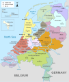
English: Map of the Netherlands (including the special municipalities of Saba, Saint Eustatius and Bonaire; the Caribbean Netherlands), showing provinces, large cities, rivers and lakes. Greek Version. Ελληνικά: Χάρτη των Κάτω Χωρών (συμπεριλαμβανομένων των ειδικών δήμων της Σάμπα, Άγιου Ευσταθίου και Μποναίρ), δείχνοντας επαρχίες, μεγάλες πόλεις, ποτάμια και λίμνες. |
| Date | |
| Source | File:Map provinces Netherlands-en.svg |
| Author | Wolfymoza |
| Other versions |
[edit]
|


.svg)
Licensing
I, the copyright holder of this work, hereby publish it under the following license:
This file is licensed under the Creative Commons Attribution-Share Alike 3.0 Unported license.
- You are free:
- to share – to copy, distribute and transmit the work
- to remix – to adapt the work
- Under the following conditions:
- attribution – You must give appropriate credit, provide a link to the license, and indicate if changes were made. You may do so in any reasonable manner, but not in any way that suggests the licensor endorses you or your use.
- share alike – If you remix, transform, or build upon the material, you must distribute your contributions under the same or compatible license as the original.
Captions
Add a one-line explanation of what this file represents
Items portrayed in this file
depicts
5 February 2015
File history
Click on a date/time to view the file as it appeared at that time.
| Date/Time | Thumbnail | Dimensions | User | Comment | |
|---|---|---|---|---|---|
| current | 07:58, 12 February 2015 | | 743 × 881 (887 KB) | Wolfymoza | Name corrections |
| 07:49, 11 February 2015 |  | 743 × 881 (887 KB) | Wolfymoza | Διορθώσεις ονομάτων. Name corrections. | |
| 07:18, 6 February 2015 |  | 743 × 881 (887 KB) | Wolfymoza | Διόρθωση ονομάτων. Correction of auto-translate and names. | |
| 20:17, 5 February 2015 |  | 743 × 881 (889 KB) | Wikibelgiaan | User created page with UploadWizard |
File usage
No pages on the English Wikipedia use this file (pages on other projects are not listed).
Global file usage
The following other wikis use this file:
- Usage on el.wikipedia.org
Metadata
This file contains additional information, probably added from the digital camera or scanner used to create or digitize it.
If the file has been modified from its original state, some details may not fully reflect the modified file.
| Width | 743 |
|---|---|
| Height | 881 |
Retrieved from "https://en.wikipedia.org/wiki/File:Map_provinces_Netherlands-el.svg"