File:Map_of_les_saintes.gif
From Wikipedia, the free encyclopedia
No higher resolution available.
Map_of_les_saintes.gif (500 × 369 pixels, file size: 14 KB, MIME type: image/gif)
| This is a file from the Wikimedia Commons. Information from its description page there is shown below. Commons is a freely licensed media file repository. You can help. |
Summary
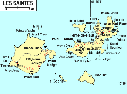
| DescriptionMap of les saintes.gif |
English: map of les Saintes, from 1993 |
| Date | |
| Source | Guide Visa-En Guadeloupe, 1993 |
| Author | Hachette Livre |
Licensing
| This file is made available under the Creative Commons CC0 1.0 Universal Public Domain Dedication. | |
| The person who associated a work with this deed has dedicated the work to the public domain by waiving all of their rights to the work worldwide under copyright law, including all related and neighboring rights, to the extent allowed by law. You can copy, modify, distribute and perform the work, even for commercial purposes, all without asking permission.
http://creativecommons.org/publicdomain/zero/1.0/deed.enCC0Creative Commons Zero, Public Domain Dedicationfalsefalse |
Captions
Add a one-line explanation of what this file represents
Items portrayed in this file
depicts
4 December 2011
File history
Click on a date/time to view the file as it appeared at that time.
| Date/Time | Thumbnail | Dimensions | User | Comment | |
|---|---|---|---|---|---|
| current | 23:32, 4 December 2011 | | 500 × 369 (14 KB) | Moowgly |
File usage
The following pages on the English Wikipedia use this file (pages on other projects are not listed):
- Anse Crawen, les Saintes
- Anse Figuier, les Saintes
- Anse Galet, les Saintes
- Anse Mire
- Anse Rodrigue, les Saintes
- Anse des Mûriers, les Saintes
- Anse à Cointe, les Saintes
- Coquelet, les Saintes
- Fond-du-Curé
- Fort Napoléon, les Saintes
- Grand-Baie, les Saintes
- Grand-Îlet
- Grande-Anse, Terre-de-Bas
- Grande-Anse, les Saintes
- La Convalescence, les Saintes
- La Coulée, les Saintes
- La Savane, les Saintes
- Le Mapou, les Saintes
- Maison blanche, les Saintes
- Marigot, les Saintes
- Mouillage, les Saintes
- Pain-de-Sucre
- Petite-Anse, les Saintes
- Pompierre, Terre-de-Haut
- Prés Cassin, les Saintes
- Vieille Anse, les Saintes
- Îles des Saintes
- Îlet à Cabrit
Global file usage
The following other wikis use this file:
- Usage on de.wikipedia.org
- Usage on el.wikipedia.org
- Usage on gl.wikipedia.org
- Usage on it.wikipedia.org
- Usage on ja.wikipedia.org
- Usage on nl.wikipedia.org
- Usage on pt.wikipedia.org
- Usage on ru.wikipedia.org
- Usage on uk.wikipedia.org
- Usage on ur.wikipedia.org
- Usage on vi.wikipedia.org
- Usage on www.wikidata.org
- Usage on zh.wikipedia.org
Retrieved from "https://en.wikipedia.org/wiki/File:Map_of_les_saintes.gif"