File:Map_of_Shootings_at_Kent_State_University_in_1970.jpg
From Wikipedia, the free encyclopedia
Original file (1,200 × 935 pixels, file size: 364 KB, MIME type: image/jpeg)
| This is a file from the Wikimedia Commons. Information from its description page there is shown below. Commons is a freely licensed media file repository. You can help. |
Summary
| DescriptionMap of Shootings at Kent State University in 1970.jpg |
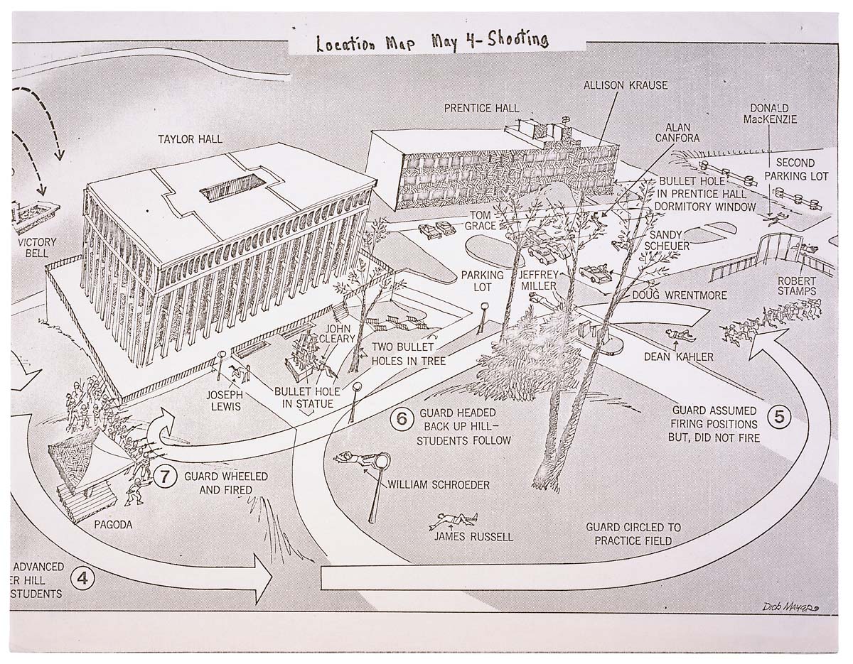
English: This is a printed map detailing the locations of structures, troop movements, bullet hole locations, and locations of casualties at the Kent State shooting of May 4, 1970. |
|||
| Date | 5/04/1970 | |||
| Source | https://catalog.archives.gov/id/596837 | |||
| Author | President (1969-1974 : Nixon). President's Commission on Campus Unrest. | |||
| Permission (Reusing this file) |
|
Licensing
| Public domainPublic domainfalsefalse |
This work is in the public domain in the United States because it is a work prepared by an officer or employee of the United States Government as part of that person’s official duties under the terms of Title 17, Chapter 1, Section 105 of the US Code.
Note: This only applies to original works of the Federal Government and not to the work of any individual U.S. state, territory, commonwealth, county, municipality, or any other subdivision. This template also does not apply to postage stamp designs published by the United States Postal Service since 1978. (See § 313.6(C)(1) of Compendium of U.S. Copyright Office Practices). It also does not apply to certain US coins; see The US Mint Terms of Use.
|
 | |
| This file has been identified as being free of known restrictions under copyright law, including all related and neighboring rights. | ||
https://creativecommons.org/publicdomain/mark/1.0/PDMCreative Commons Public Domain Mark 1.0falsefalse
File history
Click on a date/time to view the file as it appeared at that time.
| Date/Time | Thumbnail | Dimensions | User | Comment | |
|---|---|---|---|---|---|
| current | 01:26, 9 June 2008 | | 1,200 × 935 (364 KB) | Goldfishbutt | {{Information |Description={{en|1=This is a printed map detailing the locations of structures, troop movements, bullet hole locations, and locations of casualties at the Kent State shooting of May 4, 1970.}} |Source=http://arcweb.archives.gov/arc/arch_res |
File usage
Global file usage
The following other wikis use this file:
- Usage on af.wikipedia.org
- Usage on bar.wikipedia.org
- Usage on de.wikipedia.org
- Usage on en.wikibooks.org
- Usage on en.wikiquote.org
- Usage on fr.wikipedia.org
- Usage on he.wikipedia.org
- Usage on it.wikipedia.org
- Usage on ja.wikipedia.org
- Usage on nl.wikipedia.org
- Usage on no.wikipedia.org
- Usage on sv.wikipedia.org
- Usage on zh.wikipedia.org
Metadata
This file contains additional information, probably added from the digital camera or scanner used to create or digitize it.
If the file has been modified from its original state, some details may not fully reflect the modified file.
| Image title | Map of Kent State
"Location Map May 4-Shooting" 08780_2005_001 |
|---|---|
| Width | 3,079 px |
| Height | 2,400 px |
| Compression scheme | LZW |
| Pixel composition | RGB |
| Orientation | Normal |
| Number of components | 3 |
| Horizontal resolution | 120 dpi |
| Vertical resolution | 120 dpi |
| Data arrangement | chunky format |
| Software used | Adobe Photoshop CS2 Macintosh |
| File change date and time | 10:45, 7 January 2007 |
| Color space | sRGB |