File:Map_New_Zealand_Geology.jpg
From Wikipedia, the free encyclopedia
Size of this preview: 483 × 600 pixels. Other resolutions: 193 × 240 pixels | 386 × 480 pixels | 618 × 768 pixels | 825 × 1,024 pixels | 2,255 × 2,800 pixels.
Original file (2,255 × 2,800 pixels, file size: 1.21 MB, MIME type: image/jpeg)
| This is a file from the Wikimedia Commons. Information from its description page there is shown below. Commons is a freely licensed media file repository. You can help. |
Summary
| DescriptionMap New Zealand Geology.jpg |
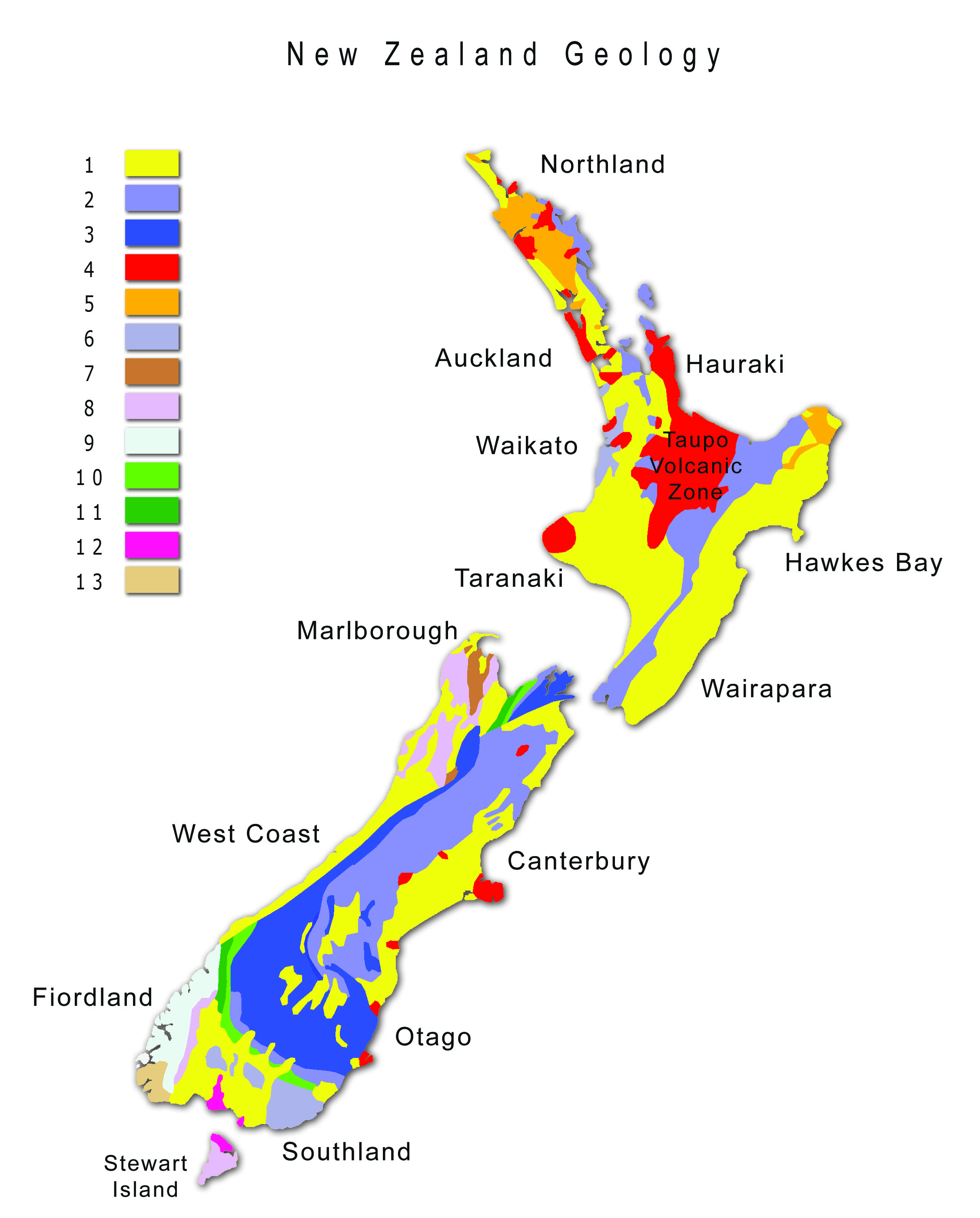
English: Map of New Zealand Geology. Legend/Key: 1=Sediments (Cretaceous and Cenozoic); 2=Greywacke (Permian and Triassic); 3=Schist (Carboniferous to Cretaceous); 4=Volcanic rocks (Cretaceous and Cenozoic); 5= Sediments and ophiolites (Northland and East Coast allochthon) (Cretaceous and Oligocene); 6=Pyroclastic rocks (Triassic and Jurassic); 7=Limestone, clastics and volcanic rocks (Central and Eastern sedimentary zone) (Cambrian to Devonian); 8=Granitoids (Paleozoic and Cretaceous); 9=West Fiordland metamorphic zone (Paleozoic and Cretaceous); 10=Ophiolites and pyroclastics (Permian); 11=Volcanic rocks (including pyroclastics) (Permian); 12=Mafic and ultramafic complexes (Paleozoic and Cretaceous); 13=Greywacke (Western sedimentary zone) (Cambrian to Ordovician). |
| Date | |
| Source | Own work |
| Author | Ulrich Lange, Bochum, Germany |
Data of this map are based on Information from Geological and Nuclear Sciences, Lower Hutt, New Zealand (Fact Sheet of New Zealand Mineral Resources)
Licensing
I, the copyright holder of this work, hereby publish it under the following license:
This file is licensed under the Creative Commons Attribution-Share Alike 3.0 Unported license.
- You are free:
- to share – to copy, distribute and transmit the work
- to remix – to adapt the work
- Under the following conditions:
- attribution – You must give appropriate credit, provide a link to the license, and indicate if changes were made. You may do so in any reasonable manner, but not in any way that suggests the licensor endorses you or your use.
- share alike – If you remix, transform, or build upon the material, you must distribute your contributions under the same or compatible license as the original.
Captions
Add a one-line explanation of what this file represents
Items portrayed in this file
depicts
23 January 2012
File history
Click on a date/time to view the file as it appeared at that time.
| Date/Time | Thumbnail | Dimensions | User | Comment | |
|---|---|---|---|---|---|
| current | 13:47, 24 July 2013 | | 2,255 × 2,800 (1.21 MB) | Ulanwp | Name Taupo Volcanic Zone has been corrected |
| 08:46, 24 January 2012 |  | 2,255 × 2,800 (1.47 MB) | Ulanwp | Typo | |
| 08:36, 24 January 2012 |  | 2,255 × 2,800 (1.47 MB) | Ulanwp | {{Information |Description ={{en|1=Map of New Zealand Geology}} |Source ={{own}} |Author =Ulanwp |Date =2012-01-23 |Permission = |other_versions = }} Data of this map are based on Information from Geologica |
File usage
The following pages on the English Wikipedia use this file (pages on other projects are not listed):
Global file usage
The following other wikis use this file:
- Usage on es.wikipedia.org
- Usage on hu.wikipedia.org
Metadata
This file contains additional information, probably added from the digital camera or scanner used to create or digitize it.
If the file has been modified from its original state, some details may not fully reflect the modified file.
| Image title |
|
|---|---|
| Author | Ulrich Lange Bochum Germany |
| Copyright holder |
|
| Short title |
|
| Orientation | Normal |
| Horizontal resolution | 300 dpi |
| Vertical resolution | 300 dpi |
| Software used | Adobe Photoshop CS3 Macintosh |
| File change date and time | 15:43, 24 July 2013 |
| Color space | Uncalibrated |
| Image width | 2,255 px |
| Image height | 2,800 px |
| Date and time of digitizing | 17:43, 24 July 2013 |
| Date metadata was last modified | 17:43, 24 July 2013 |
| Copyright status | Copyrighted |
Retrieved from "https://en.wikipedia.org/wiki/File:Map_New_Zealand_Geology.jpg"