File:Limes2.png
From Wikipedia, the free encyclopedia
Size of this preview: 600 × 600 pixels. Other resolutions: 240 × 240 pixels | 480 × 480 pixels | 768 × 768 pixels | 1,024 × 1,024 pixels | 2,048 × 2,048 pixels | 5,906 × 5,906 pixels.
Original file (5,906 × 5,906 pixels, file size: 11.1 MB, MIME type: image/png)
| This is a file from the Wikimedia Commons. Information from its description page there is shown below. Commons is a freely licensed media file repository. You can help. |
Summary
| DescriptionLimes2.png |
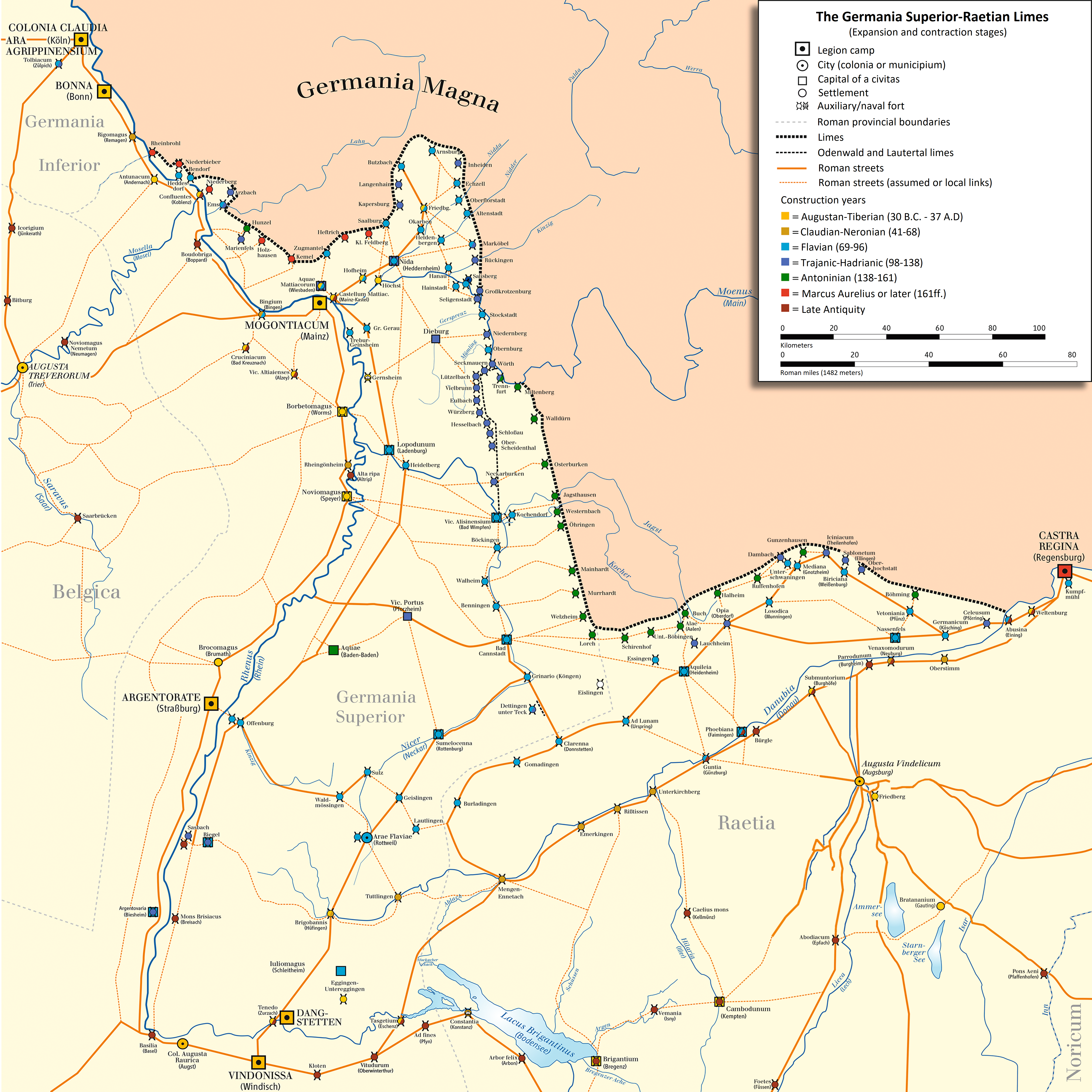
English: Map of Limes Germanicus (system of fortifications representing the boundary of Roman control in the Rhine-Danube angle)
Deutsch: Karte des Obergermanisch-Raetischen Limes |
| Date | |
| Source | own drawing/Source of Information: Martin Kemkes: „Römer an Donau und Iller. Neue Forschungen und Funde.“ Thorbecke, Sigmaringen 1996, ISBN 3-7995-0410-9, S. 152f.; Dietwulf Baatz: Der Römische Limes. Archäologische Ausflüge zwischen Rhein und Donau. 4. Auflage. Gebr. Mann, Berlin 2000, ISBN 3-7861-2347-0; Thomas Fischer und Günther Ulbert: Der Limes in Bayern. Von Dinkelsbühl bis Eining. Theiss, Stuttgart 1983, ISBN 3-8062-0351-2; Heinz Cüppers: Die Römer in Rheinland-Pfalz. Lizenzausgabe. Nikol, Hamburg 2002. ISBN 3-933203-60-0; Cliff Alexander Jost: Der römische Limes in Rheinland-Pfalz. (Archäologie an Mittelrhein und Mosel, Band 14), Landesamt für Denkmalpflege Rheinland-Pfalz, Koblenz 2003, ISBN 3-929645-07-6; Dietwulf Baatz und Fritz-Rudolf Herrmann: Die Römer in Hessen. Lizenzausgabe. Nikol, Hamburg 2002, ISBN 3-933203-58-9; Dieter Planck (Hrsg.): Die Römer in Baden-Württemberg. Theiss, Stuttgart 2005, ISBN 3-8062-1555-3; Philipp Filtzinger, Dieter Planck und Bernhard Cämmerer (Hrsg.): Die Römer in Baden-Württemberg. 3. Auflage. Theiss, Stuttgart 1986, ISBN 3-8062-0287-7; Wolfgang Czysz u.a.: Die Römer in Bayern. Lizenzausgabe. Nikol, Hamburg 2005, ISBN 3-937872-11-6; Dieter Planck u.a.: Imperium Romanum. Roms Provinzen an Neckar, Rhein und Donau. Theiss, Stuttgart 2005. ISBN 978-3-8062-2140-4 |
| Author | ziegelbrenner |
| Other versions | Italian version |

|
This historical map image could be re-created using vector graphics as an SVG file. This has several advantages; see Commons:Media for cleanup for more information. If an SVG form of this image is available, please upload it and afterwards replace this template with
{{vector version available|new image name}}.
It is recommended to name the SVG file “Limes2.svg”—then the template Vector version available (or Vva) does not need the new image name parameter. |

|
This map has been made or improved in the German Kartenwerkstatt (Map Lab). You can propose maps to improve as well.
azərbaycanca ∙ čeština ∙ Deutsch ∙ Deutsch (Sie-Form) ∙ English ∙ español ∙ français ∙ italiano ∙ latviešu ∙ magyar ∙ Nederlands ∙ Plattdüütsch ∙ polski ∙ português ∙ română ∙ sicilianu ∙ slovenščina ∙ suomi ∙ македонски ∙ русский ∙ ქართული ∙ հայերեն ∙ বাংলা ∙ ไทย ∙ +/−
|
Licensing
I, the copyright holder of this work, hereby publish it under the following licenses:

|
Permission is granted to copy, distribute and/or modify this document under the terms of the GNU Free Documentation License, Version 1.2 or any later version published by the Free Software Foundation; with no Invariant Sections, no Front-Cover Texts, and no Back-Cover Texts. A copy of the license is included in the section entitled GNU Free Documentation License.http://www.gnu.org/copyleft/fdl.htmlGFDLGNU Free Documentation Licensetruetrue |
This file is licensed under the Creative Commons Attribution-Share Alike 3.0 Unported license.
- You are free:
- to share – to copy, distribute and transmit the work
- to remix – to adapt the work
- Under the following conditions:
- attribution – You must give appropriate credit, provide a link to the license, and indicate if changes were made. You may do so in any reasonable manner, but not in any way that suggests the licensor endorses you or your use.
- share alike – If you remix, transform, or build upon the material, you must distribute your contributions under the same or compatible license as the original.
You may select the license of your choice.
| Annotations InfoField | This image is annotated: View the annotations at Commons |
2357
1589
147
147
2946
3046

Captions
Add a one-line explanation of what this file represents
Items portrayed in this file
depicts
some value
18 December 2008
File history
Click on a date/time to view the file as it appeared at that time.
| Date/Time | Thumbnail | Dimensions | User | Comment | |
|---|---|---|---|---|---|
| current | 08:18, 15 May 2024 | | 5,906 × 5,906 (11.1 MB) | Ziegelbrenner | Reverted to version as of 15:22, 15 December 2017 (UTC). Wieso englisch in der deutschen Wikipedia? |
| 19:10, 16 October 2023 |  | 5,906 × 5,906 (15.34 MB) | MrThe1And0nly | Translated the legend into English | |
| 15:22, 15 December 2017 |  | 5,906 × 5,906 (11.1 MB) | Mediatus | Gauting eingefügt | |
| 19:29, 14 December 2017 |  | 5,906 × 5,906 (11.09 MB) | Mediatus | Pförring verbessert | |
| 17:03, 14 December 2017 |  | 5,906 × 5,906 (11.09 MB) | Mediatus | Nachträge und Verbesserungen | |
| 14:52, 19 June 2017 |  | 5,906 × 5,906 (13.22 MB) | Mediatus | Augsburger Raum nach LDA | |
| 10:22, 19 June 2017 |  | 2,946 × 3,046 (2.74 MB) | Mediatus | gef. | |
| 16:52, 16 January 2017 |  | 2,953 × 2,953 (2.73 MB) | Ziegelbrenner | corrected | |
| 15:59, 16 March 2013 |  | 2,946 × 3,046 (2.74 MB) | Mediatus | ausgebaut | |
| 13:47, 13 October 2011 |  | 2,362 × 2,440 (1.87 MB) | Ziegelbrenner | 2011-10-13 |
File usage
The following pages on the English Wikipedia use this file (pages on other projects are not listed):
Global file usage
The following other wikis use this file:
- Usage on als.wikipedia.org
- Usage on bar.wikipedia.org
- Usage on bs.wikipedia.org
- Usage on cs.wikipedia.org
- Usage on da.wikipedia.org
- Usage on de.wikipedia.org
- Konstanz
- Obergermanisch-Raetischer Limes
- Augusta Vindelicum
- Diskussion:Obergermanisch-Raetischer Limes
- Liste der Kastelle am Obergermanisch-Raetischen Limes
- Antunnacum
- Limes (Grenzwall)
- Urgeschichte Baden-Württembergs
- Metropolregion Rhein-Neckar
- Castra Regina
- Donau-Iller-Rhein-Limes
- Kastell Köngen
- Neckar-Odenwald-Limes
- Via Danubia
- Wetterau
- Borbetomagus
- Kastell Eining
- Iuliomagus (Schleitheim)
- Kastell Wimpfen im Tal
- Kastell Heilbronn-Böckingen
- Kastell Ennetach
- Kastell Rißtissen
- Wikipedia:Redaktion Altertum/Römischer Limes
- Vorlage Diskussion:Infobox Limeskastell
- Kastell Benningen
- Kastell Stuttgart-Bad Cannstatt
- Kastelle von Walheim
- Kastell Sulz
- Kastell Waldmössingen
- Kastell Emerkingen
- Kastell Hüfingen
- Kastell Unterkirchberg
- Kastell Tuttlingen
- Kastell Boppard
- Wikipedia:Redaktion Altertum/Römischer Limes/Pictothek
- Kleinkastell „Auf der Schanz“
- Kastell Alzey
- Wikipedia:Redaktion Altertum/Römischer Limes/Sonstige Baustellen
View more global usage of this file.
Metadata
This file contains additional information, probably added from the digital camera or scanner used to create or digitize it.
If the file has been modified from its original state, some details may not fully reflect the modified file.
| Horizontal resolution | 236.22 dpc |
|---|---|
| Vertical resolution | 236.22 dpc |
Retrieved from "https://en.wikipedia.org/wiki/File:Limes2.png"