File:Kepler-world.jpg
From Wikipedia, the free encyclopedia
Original file (3,433 × 2,000 pixels, file size: 9.16 MB, MIME type: image/jpeg)
| This is a file from the Wikimedia Commons. Information from its description page there is shown below. Commons is a freely licensed media file repository. You can help. |
Summary
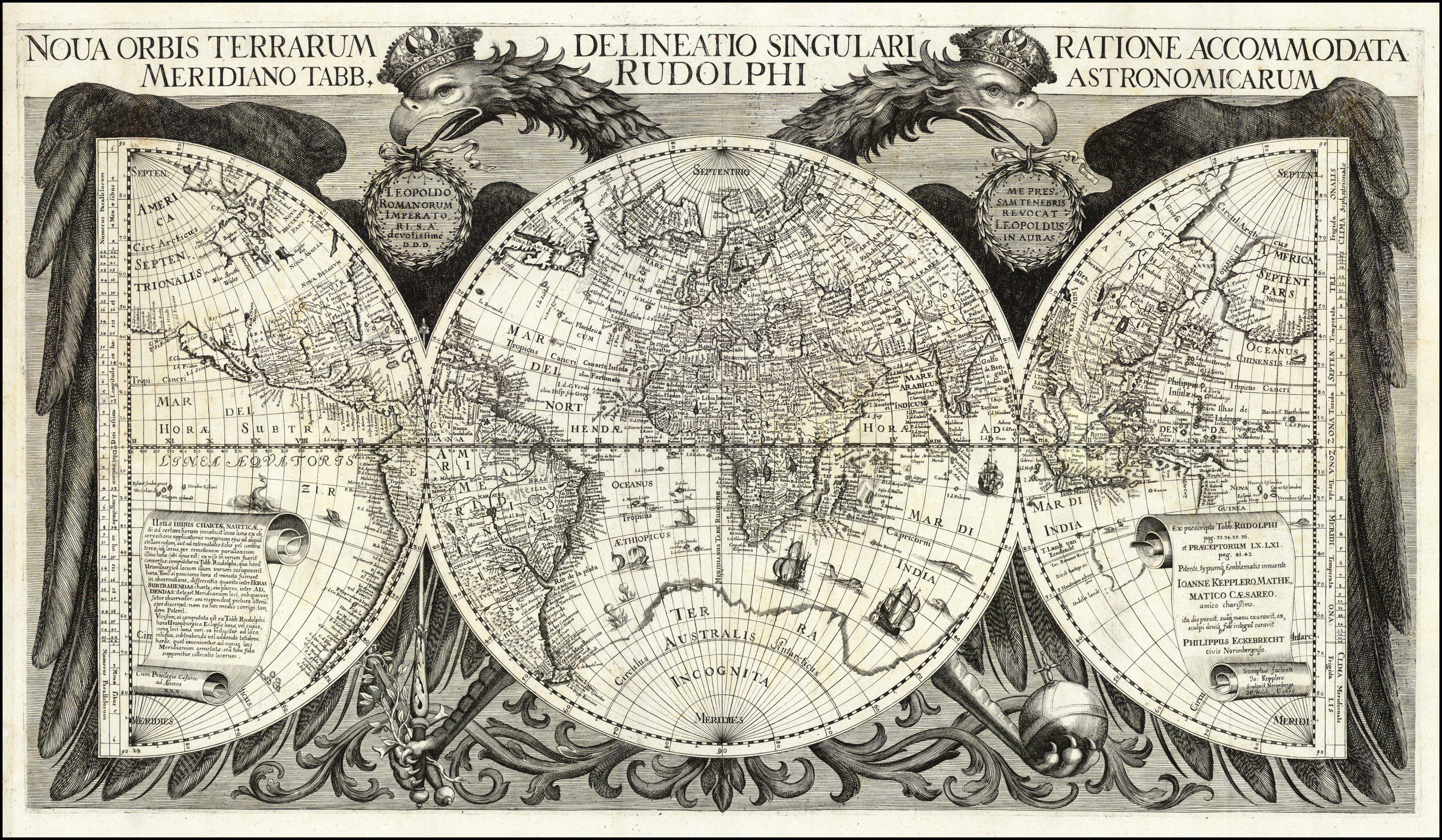
| DescriptionKepler-world.jpg |
English: World map in: "Tabulae Rudolphinae : quibus astronomicae ...." by Johannes Kepler, 1627. |
| Date | |
| Source | https://web.archive.org/web/20081006170924/http://www.photolib.noaa.gov/htmls/libr0312.htm |
| Author | Unknown authorUnknown author |
Licensing
|
This is a faithful photographic reproduction of a two-dimensional, public domain work of art. The work of art itself is in the public domain for the following reason:
The official position taken by the Wikimedia Foundation is that "faithful reproductions of two-dimensional public domain works of art are public domain".
This photographic reproduction is therefore also considered to be in the public domain in the United States. In other jurisdictions, re-use of this content may be restricted; see Reuse of PD-Art photographs for details. | |||||
Captions
Items portrayed in this file
depicts
44,444
Reference
1627
image/jpeg
File history
Click on a date/time to view the file as it appeared at that time.
| Date/Time | Thumbnail | Dimensions | User | Comment | |
|---|---|---|---|---|---|
| current | 22:56, 2 June 2019 | | 3,433 × 2,000 (9.16 MB) | Fitmoos | more resolution |
| 16:08, 4 May 2011 |  | 1,776 × 1,056 (555 KB) | Esquilo | Converted to true greyscale | |
| 20:34, 15 May 2010 |  | 1,776 × 1,056 (1.59 MB) | Ras67 | losslessly cropped with Jpegcrop | |
| 18:37, 18 August 2007 |  | 1,780 × 1,128 (1.69 MB) | QWerk | ||
| 09:45, 5 October 2004 |  | 700 × 443 (151 KB) | Robbot | World map in: "Tabulae Rudolphinae : quibus astronomicae ...." by Johannes Kepler. Source: NOAA {{PD}} |
File usage
- Antique
- Rudolphine Tables
- User:Arsivis
- User:DSC~enwiki
- User:Don Stroud
- User:Dryzen
- User:Ewan.L
- User:LikeRealTimes
- User:Nathancraig
- User:Rustbelt Maps
- User:Samantha Carter
- User:Scwlong
- User:Srwalden
- User:Vazgen Ghazaryan
- User:Vizmap
- Wikipedia:Userboxes/Occupations/Construction
- Template:User Cartography
- Portal:History of science/Picture
- Portal:History of science/Picture/6
- Portal:History of science/Previous pictures
- Portal:Maps/Selected article
- Portal:Maps/Selected article/1
- Portal talk:History of science/Picture
Global file usage
The following other wikis use this file:
- Usage on ar.wikipedia.org
- Usage on arz.wikipedia.org
- Usage on ast.wikipedia.org
- Usage on bg.wikipedia.org
- Usage on bs.wikipedia.org
- Usage on ca.wikipedia.org
- Usage on ce.wikipedia.org
- Usage on chr.wikipedia.org
- Usage on co.wikipedia.org
- Usage on cy.wikipedia.org
- Usage on de.wikipedia.org
- Usage on el.wikipedia.org
- Usage on en.wiktionary.org
- Usage on eo.wikipedia.org
- Usage on es.wikipedia.org
- Usage on et.wikipedia.org
- Usage on et.wikiquote.org
- Usage on eu.wikipedia.org
- Usage on eu.wiktionary.org
- Usage on fi.wiktionary.org
- Usage on fr.wikipedia.org
View more global usage of this file.
Metadata
This file contains additional information, probably added from the digital camera or scanner used to create or digitize it.
If the file has been modified from its original state, some details may not fully reflect the modified file.
| Width | 11,635 px |
|---|---|
| Height | 7,801 px |
| Bits per component |
|
| Compression scheme | Uncompressed |
| Pixel composition | RGB |
| Orientation | Normal |
| Number of components | 3 |
| Horizontal resolution | 400 dpi |
| Vertical resolution | 400 dpi |
| Data arrangement | chunky format |
| Software used | Adobe Photoshop CS3 Windows |
| File change date and time | 13:19, 22 January 2015 |
| Color space | sRGB |
| Image width | 3,433 px |
| Image height | 2,000 px |
| Date and time of digitizing | 05:19, 22 January 2015 |
| Date metadata was last modified | 05:19, 22 January 2015 |