File:Karte_Slovenj_Gradec_si.png
From Wikipedia, the free encyclopedia
No higher resolution available.
Karte_Slovenj_Gradec_si.png (300 × 201 pixels, file size: 44 KB, MIME type: image/png)
| This is a file from the Wikimedia Commons. Information from its description page there is shown below. Commons is a freely licensed media file repository. You can help. |
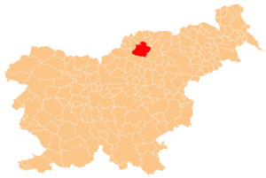
Deutsch: Karte der Gemeinde Slovenj Gradec in Slowenien. Hergestellt vom Benutzer Plp der slowenischen Wikipedia.
English: Localization of Slovenj Gradec in Slovenia. Creator Plp

|
Permission is granted to copy, distribute and/or modify this document under the terms of the GNU Free Documentation License, Version 1.2 or any later version published by the Free Software Foundation; with no Invariant Sections, no Front-Cover Texts, and no Back-Cover Texts. A copy of the license is included in the section entitled GNU Free Documentation License.http://www.gnu.org/copyleft/fdl.htmlGFDLGNU Free Documentation Licensetruetrue |
| This file is licensed under the Creative Commons Attribution-Share Alike 3.0 Unported license. | ||
| ||
| This licensing tag was added to this file as part of the GFDL licensing update.http://creativecommons.org/licenses/by-sa/3.0/CC BY-SA 3.0Creative Commons Attribution-Share Alike 3.0truetrue |
Captions
Add a one-line explanation of what this file represents
Items portrayed in this file
depicts
File history
Click on a date/time to view the file as it appeared at that time.
| Date/Time | Thumbnail | Dimensions | User | Comment | |
|---|---|---|---|---|---|
| current | 19:54, 19 July 2005 | | 300 × 201 (44 KB) | Besednjak~commonswiki | Karte der Gemeinde Slovenj Gradec in Slowenien. Hergestellt von Benutzer Plp der sl.wikipedia. {{GFDL}} |
File usage
The following pages on the English Wikipedia use this file (pages on other projects are not listed):
- Brda, Slovenj Gradec
- Gmajna, Slovenj Gradec
- Golavabuka
- Gradišče, Slovenj Gradec
- Graška Gora
- Hugo Wolf
- Lado Kralj
- Legen
- Marko Šuler
- Mirnes Šišić
- Mislinjska Dobrava
- Pameče
- Podgorje, Slovenj Gradec
- Raduše
- Sele, Slovenj Gradec
- Slovenj Gradec
- Spodnji Razbor
- Stari Trg, Slovenj Gradec
- Tomaška Vas
- Troblje
- Turiška Vas, Slovenj Gradec
- Urban Municipality of Slovenj Gradec
- Vodriž
- Vrhe, Slovenj Gradec
- Zgornji Razbor
- Šmartno pri Slovenj Gradcu
- Šmiklavž, Slovenj Gradec
- Template:Slovenj Gradec
Global file usage
The following other wikis use this file:
- Usage on ar.wikipedia.org
- Usage on arz.wikipedia.org
- Usage on ast.wikipedia.org
- Usage on ba.wikipedia.org
- Usage on ca.wikipedia.org
- Usage on ceb.wikipedia.org
- Usage on cs.wikipedia.org
- Usage on de.wikipedia.org
- Usage on el.wikipedia.org
- Usage on eo.wikipedia.org
- Usage on es.wikipedia.org
- Usage on eu.wikipedia.org
- Usage on fa.wikipedia.org
- Usage on hr.wikipedia.org
- Usage on hu.wikipedia.org
- Usage on it.wikipedia.org
- Usage on ja.wikipedia.org
- Usage on ko.wikipedia.org
- Usage on la.wikipedia.org
- Usage on mdf.wikipedia.org
- Usage on nl.wikipedia.org
- Usage on pl.wikipedia.org
- Usage on pt.wikipedia.org
- Usage on ro.wikipedia.org
- Usage on ru.wikipedia.org
- Usage on sco.wikipedia.org
- Usage on sh.wikipedia.org
- Usage on sk.wikipedia.org
- Usage on sl.wikipedia.org
- Usage on smn.wikipedia.org
- Usage on sr.wikipedia.org
- Usage on tt.wikipedia.org
- Usage on uk.wikipedia.org
- Usage on vi.wikipedia.org
- Usage on vo.wikipedia.org
- Usage on www.wikidata.org
- Usage on zh.wikipedia.org
Retrieved from "https://en.wikipedia.org/wiki/File:Karte_Slovenj_Gradec_si.png"