File:Karte_Kanton_Freiburg_2010.png
From Wikipedia, the free encyclopedia
Size of this preview: 590 × 599 pixels. Other resolutions: 236 × 240 pixels | 472 × 480 pixels | 756 × 768 pixels | 1,008 × 1,024 pixels | 2,066 × 2,099 pixels.
Original file (2,066 × 2,099 pixels, file size: 948 KB, MIME type: image/png)
| This is a file from the Wikimedia Commons. Information from its description page there is shown below. Commons is a freely licensed media file repository. You can help. |
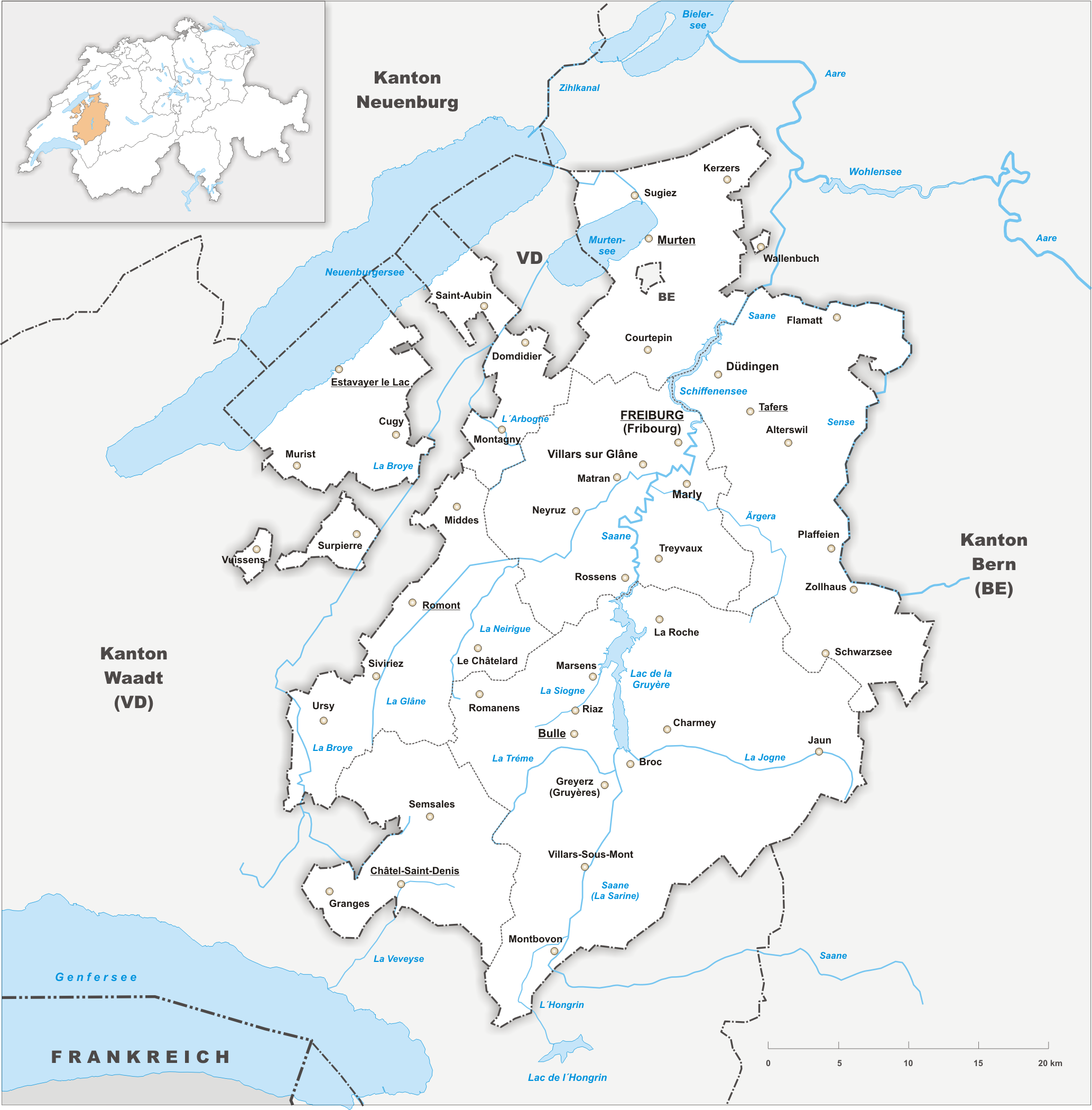
| DescriptionKarte Kanton Freiburg 2010.png |
Deutsch: Karte des Kanton Freiburg. |
||||||||
| Date | |||||||||
| Source | Own work | ||||||||
| Author | Tschubby | ||||||||
| Permission (Reusing this file) |
I, the copyright holder of this work, hereby publish it under the following licenses:
This file is licensed under the Creative Commons Attribution-Share Alike 2.5 Generic, 2.0 Generic and 1.0 Generic license.
You may select the license of your choice. |

Captions
Map of the canton of Friborg
Items portrayed in this file
depicts
22 October 2009
image/png
File history
Click on a date/time to view the file as it appeared at that time.
| Date/Time | Thumbnail | Dimensions | User | Comment | |
|---|---|---|---|---|---|
| current | 21:34, 15 March 2022 | | 2,066 × 2,099 (948 KB) | Delusion23 | Removed BE |
| 21:27, 15 March 2022 |  | 2,066 × 2,099 (949 KB) | Delusion23 | Clavaleyres now part of Fribourg | |
| 20:28, 22 October 2009 |  | 2,066 × 2,099 (1.09 MB) | Tschubby | {{Information |Description= |Source= |Date= |Author= |Permission= |other_versions= }} | |
| 20:13, 22 October 2009 |  | 2,066 × 2,099 (1.08 MB) | Tschubby | {{Information |Description= {{de| Karte des Kanton Freiburg.}} |Source={{own}} |Date= 22.10.2009 |Author= Tschubby |Permission= {{self|GFDL|Cc-by-sa-3.0-migrated|Cc-by-sa-2.5,2.0,1.0}} }} [[Category:Maps of t |
File usage
The following pages on the English Wikipedia use this file (pages on other projects are not listed):
Global file usage
The following other wikis use this file:
- Usage on ar.wikipedia.org
- Usage on ast.wikipedia.org
- Usage on be-tarask.wikipedia.org
- Usage on be.wikipedia.org
- Usage on bg.wikipedia.org
- Usage on ca.wikipedia.org
- Usage on ceb.wikipedia.org
- Usage on el.wikipedia.org
- Usage on eu.wikipedia.org
- Usage on gl.wikipedia.org
- Usage on hu.wikipedia.org
- Usage on ia.wikipedia.org
- Usage on ilo.wikipedia.org
- Usage on li.wikipedia.org
- Usage on lld.wikipedia.org
- Usage on lmo.wikipedia.org
- Usage on mk.wikipedia.org
- Usage on mzn.wikipedia.org
- Usage on nl.wikipedia.org
- Usage on oc.wikipedia.org
- Usage on sk.wikipedia.org
- Usage on sr.wikipedia.org
- Usage on th.wikipedia.org
- Usage on ur.wikipedia.org
- Usage on www.wikidata.org
Metadata
This file contains additional information, probably added from the digital camera or scanner used to create or digitize it.
If the file has been modified from its original state, some details may not fully reflect the modified file.
| Horizontal resolution | 56.69 dpc |
|---|---|
| Vertical resolution | 56.69 dpc |
Retrieved from "https://en.wikipedia.org/wiki/File:Karte_Kanton_Freiburg_2010.png"