File:Hurricane_Emily_16_july_2005_1545Z.jpg
From Wikipedia, the free encyclopedia
Size of this preview: 466 × 599 pixels. Other resolutions: 187 × 240 pixels | 373 × 480 pixels | 597 × 768 pixels | 796 × 1,024 pixels | 1,593 × 2,048 pixels | 5,600 × 7,200 pixels.
Original file (5,600 × 7,200 pixels, file size: 6.25 MB, MIME type: image/jpeg)
| This is a file from the Wikimedia Commons. Information from its description page there is shown below. Commons is a freely licensed media file repository. You can help. |
Summary
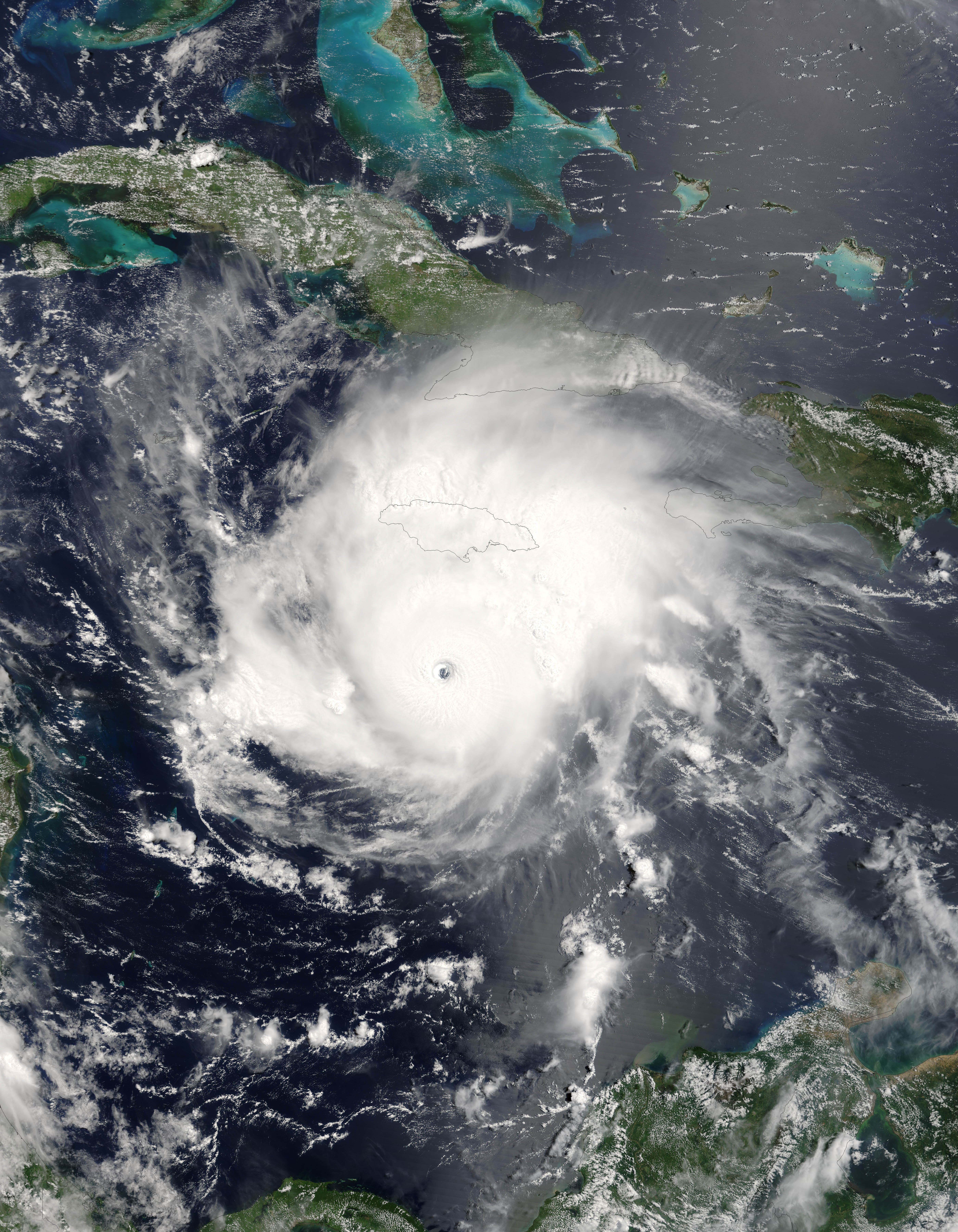
| DescriptionHurricane Emily 16 july 2005 1545Z.jpg |
Hurricane Emily was spinning through the Caribbean south of Jamacia on July 16, 2005, when the Moderate Resolution Imaging Spectroradiometer (MODIS) on the Terra satellite captured this image at 15:45 UTC (11:45 a.m. Eastern Daylight Time). At this time, Emily was a well-developed hurricane with winds over 230 kilometers an hour (125 knots) and gusts as high as 285 km/hr (155 knots). As shown in this satellite image, the storm is passing roughly east to west well south of Jamaica (around 160 kilometers, or 100 miles), but the heavy rains in the storm's outer bands fell on an already sodden island still recovering from Hurricane Dennis, which similarly glanced the island on July 7. Emily's rains caused flooding, which has resulted in four deaths on the island. Tourists in the Yucatan Peninsula are being evacuated from resort areas and beaches as the hurricane continues on track to make landfall there during the morning of July 18, 2005. |
||||||
| Date | |||||||
| Source | http://earthobservatory.nasa.gov/NaturalHazards/natural_hazards_v2.php3?img_id=12967 | ||||||
| Author | NASA image provided courtesy of Jeff Schmaltz, MODIS Rapid Response team. | ||||||
| Permission (Reusing this file) |
|
||||||
| Other versions | Image:Hurricane Emily.jpg |

Captions
Add a one-line explanation of what this file represents
Items portrayed in this file
depicts
16 July 2005
image/jpeg
File history
Click on a date/time to view the file as it appeared at that time.
| Date/Time | Thumbnail | Dimensions | User | Comment | |
|---|---|---|---|---|---|
| current | 09:44, 31 July 2023 | | 5,600 × 7,200 (6.25 MB) | Nino Marakot | Reverted to version as of 06:40, 23 July 2018 (UTC) |
| 22:56, 6 December 2018 |  | 6,401 × 8,401 (9.55 MB) | FleurDeOdile | actual center | |
| 06:40, 23 July 2018 |  | 5,600 × 7,200 (6.25 MB) | Nino Marakot | Reverted to version as of 21:47, 2 November 2006 (UTC) | |
| 15:43, 22 April 2018 |  | 1,540 × 1,900 (676 KB) | CooperScience | Larger file, centered, better quality | |
| 09:04, 24 May 2017 |  | 466 × 599 (84 KB) | A1Cafel | clearer | |
| 21:47, 2 November 2006 |  | 5,600 × 7,200 (6.25 MB) | Good kitty | == Summary == {{Information |Description=Hurricane Emily was spinning through the Caribbean south of Jamacia on July 16, 2005, when the Moderate Resolution Imaging Spectroradiometer (MODIS) on the Terra satellite captured this image at 15:45 UTC (11:45 a. |
File usage
The following pages on the English Wikipedia use this file (pages on other projects are not listed):
Global file usage
The following other wikis use this file:
- Usage on ca.wikipedia.org
- Usage on de.wikipedia.org
- Usage on eo.wikipedia.org
- Usage on es.wikipedia.org
- Usage on eu.wikipedia.org
- Usage on fi.wikipedia.org
- Usage on fr.wikipedia.org
- Usage on hu.wikipedia.org
- Usage on it.wikipedia.org
- Usage on pl.wikipedia.org
- Usage on pt.wikipedia.org
- Usage on ru.wikipedia.org
- Usage on simple.wikipedia.org
- Usage on sv.wikipedia.org
- Usage on uk.wikipedia.org
- Usage on vi.wikipedia.org
- Usage on www.wikidata.org
- Usage on zh.wikipedia.org