File:Hampshire_County_Courthouse_Romney_WV_2014_10_05_05.JPG
From Wikipedia, the free encyclopedia
Size of this preview: 800 × 600 pixels. Other resolutions: 320 × 240 pixels | 640 × 480 pixels | 1,024 × 768 pixels | 1,280 × 960 pixels | 2,560 × 1,920 pixels | 3,264 × 2,448 pixels.
Original file (3,264 × 2,448 pixels, file size: 2.02 MB, MIME type: image/jpeg)
| This is a file from the Wikimedia Commons. Information from its description page there is shown below. Commons is a freely licensed media file repository. You can help. |
Summary
| DescriptionHampshire County Courthouse Romney WV 2014 10 05 05.JPG |
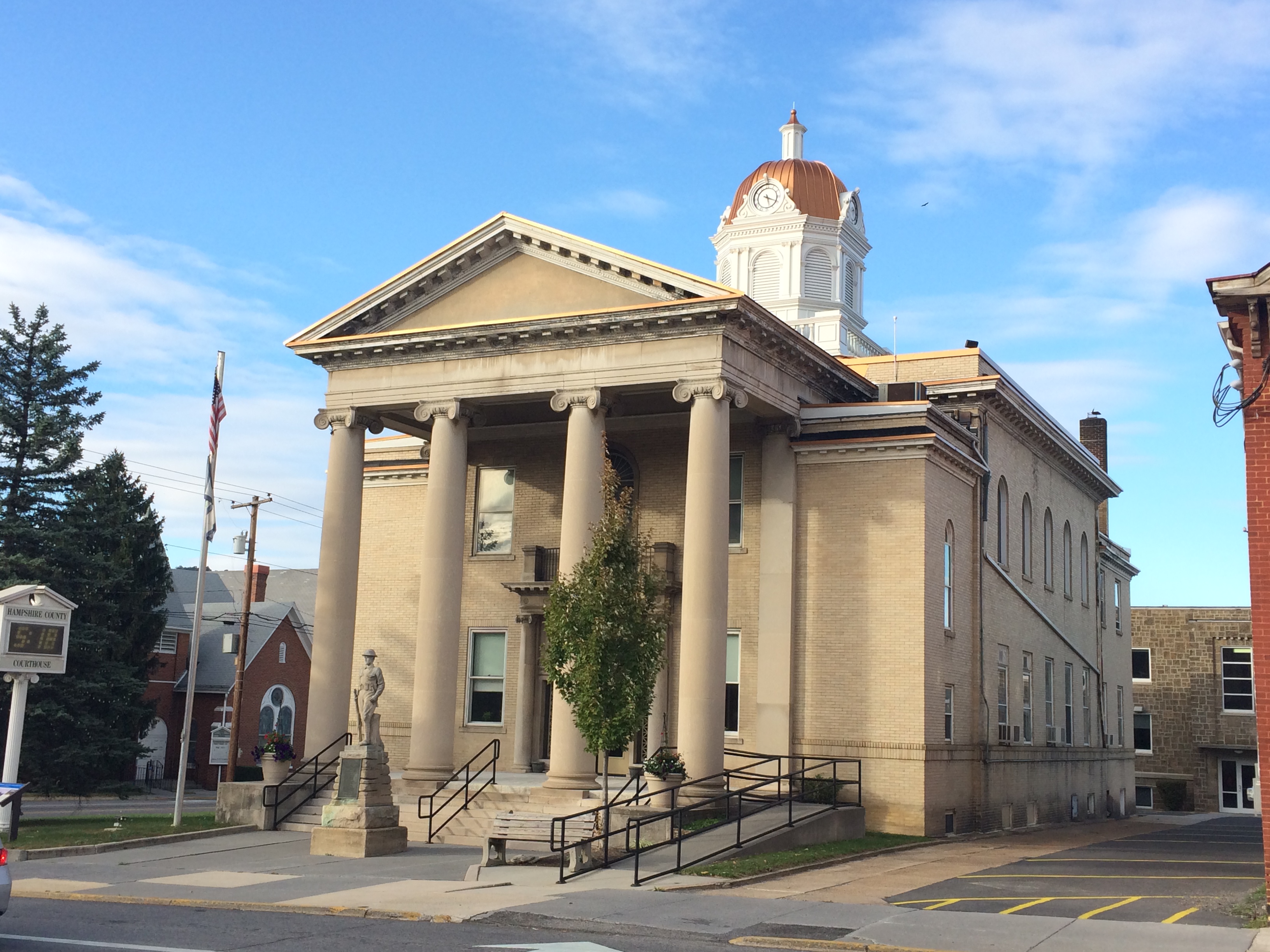
English: The Hampshire County Courthouse in Romney, West Virginia, following the restoration of its dome. Photographed by Justin A. Wilcox of Washington, D.C. on October 5, 2014. |
| Date | |
| Source | Own work |
| Author | Justin.A.Wilcox |
| Camera location | 39° 20′ 30.46″ N, 78° 45′ 21.95″ W | View this and other nearby images on: OpenStreetMap |
|---|
|
This is an image of a place or building that is listed on the National Register of Historic Places in the United States of America. Its reference number is 05001006. |
Licensing
I, the copyright holder of this work, hereby publish it under the following license:
This file is licensed under the Creative Commons Attribution-Share Alike 4.0 International license.
- You are free:
- to share – to copy, distribute and transmit the work
- to remix – to adapt the work
- Under the following conditions:
- attribution – You must give appropriate credit, provide a link to the license, and indicate if changes were made. You may do so in any reasonable manner, but not in any way that suggests the licensor endorses you or your use.
- share alike – If you remix, transform, or build upon the material, you must distribute your contributions under the same or compatible license as the original.
Captions
Add a one-line explanation of what this file represents
Items portrayed in this file
depicts
some value
5 October 2014
39°20'30.459999998"N, 78°45'21.949999999"W
File history
Click on a date/time to view the file as it appeared at that time.
| Date/Time | Thumbnail | Dimensions | User | Comment | |
|---|---|---|---|---|---|
| current | 22:41, 6 October 2014 | | 3,264 × 2,448 (2.02 MB) | Quercus montana | User created page with UploadWizard |
File usage
More than 100 pages use this file. The following list shows the first 100 pages that use this file only. A full list is available.
- Hampshire County, West Virginia
- List of historic sites in Hampshire County, West Virginia
- Talk:33rd Virginia Infantry Regiment
- Talk:Alexander White (Virginia politician)
- Talk:Ann Pancake
- Talk:Augusta, West Virginia
- Talk:Baker Mountain (West Virginia)
- Talk:Battle of Great Cacapon
- Talk:Bear Garden Mountain
- Talk:Bearwallow Creek
- Talk:Big Run (South Branch Potomac River tributary)
- Talk:Cacapon Mountain
- Talk:Cacapon River
- Talk:Capon Springs Run
- Talk:Captain David Pugh House
- Talk:Castle Mountain (Hampshire County, West Virginia)
- Talk:Charles S. Lawrence
- Talk:Chet Pancake
- Talk:Confederate Memorial (Romney, West Virginia)
- Talk:Cooper Mountain (West Virginia)
- Talk:Cornelia Peake McDonald
- Talk:Delray, West Virginia
- Talk:Dillons Run
- Talk:Edwards Run
- Talk:Felix Walker (American politician)
- Talk:Forks of Cacapon, West Virginia
- Talk:Fort Capon
- Talk:Fort Cox, West Virginia
- Talk:Fort Mill Ridge Civil War Trenches
- Talk:Fort Pearsall
- Talk:Francis White (Virginia politician)
- Talk:George Preston Marshall
- Talk:George Washington and Jefferson National Forests
- Talk:Glebe, West Virginia
- Talk:Grassy Lick Run
- Talk:Great Appalachian Valley
- Talk:Great North Mountain
- Talk:Green Spring, West Virginia
- Talk:Green Spring Run
- Talk:Hampshire County, West Virginia
- Talk:Henepola Gunaratana
- Talk:Herman G. Kump
- Talk:High Knob (West Virginia)
- Talk:Ice Mountain
- Talk:Indian Mound Cemetery
- Talk:Jesse B. Aikin
- Talk:John J. Cornwell
- Talk:John J. Jacob (West Virginia politician)
- Talk:Jonah Edward Kelley
- Talk:Joseph Neville
- Talk:Ken Hechler
- Talk:Kirby, West Virginia
- Talk:List of historical highway markers in Hampshire County, West Virginia
- Talk:Little Cacapon River
- Talk:McNeill's Rangers
- Talk:Mechanicsburg Gap
- Talk:Mill Branch (Cacapon River tributary)
- Talk:Mill Creek (South Branch Potomac River tributary)
- Talk:Mill Run (South Branch Potomac River tributary)
- Talk:North River (Cacapon River tributary)
- Talk:Northwestern Turnpike
- Talk:Patterson Creek Mountain
- Talk:Piss Pot Island
- Talk:Potomac Eagle Scenic Railroad
- Talk:Potomac River
- Talk:Randall Terry
- Talk:Robert White (attorney general)
- Talk:Romney, West Virginia
- Talk:Romney, West Virginia, in the American Civil War
- Talk:Romney Expedition
- Talk:Ruth Rowan
- Talk:Sam Pancake
- Talk:Short Mountain (West Virginia)
- Talk:Sloan–Parker House
- Talk:South Branch Mountain
- Talk:South Branch Valley Railroad
- Talk:Springfield, West Virginia
- Talk:Springfield Grade Road
- Talk:Stephen Ailes
- Talk:Tearcoat Creek
- Talk:The Devil's Nose
- Talk:Thomas Bryan Martin
- Talk:Three Churches, West Virginia
- Talk:Timber Ridge
- Talk:U.S. Route 220
- Talk:U.S. Route 50 in West Virginia
- Talk:USS Hampshire County
- Talk:W. Willard Wirtz
- Talk:WHMG-LP
- Talk:WVMD
- Talk:WVXS
- Talk:West Virginia Route 127
- Talk:West Virginia Route 259
- Talk:West Virginia Route 28
- Talk:West Virginia Route 29
- Talk:West Virginia Route 9
- Talk:West Virginia Schools for the Deaf and the Blind
- Talk:William Armstrong (Virginia politician)
- Talk:Wilson-Wodrow-Mytinger House
- Talk:Winchester, VA–WV MSA
View more links to this file.
Global file usage
The following other wikis use this file:
- Usage on zh.wikipedia.org
Metadata
This file contains additional information, probably added from the digital camera or scanner used to create or digitize it.
If the file has been modified from its original state, some details may not fully reflect the modified file.
| Camera manufacturer | Apple |
|---|---|
| Camera model | iPhone 5s |
| Exposure time | 1/684 sec (0.0014619883040936) |
| F-number | f/2.2 |
| ISO speed rating | 32 |
| Date and time of data generation | 17:18, 5 October 2014 |
| Lens focal length | 4.12 mm |
| Latitude | 39° 20′ 30.46″ N |
| Longitude | 78° 45′ 21.95″ W |
| Altitude | 255.671 meters above sea level |
| Orientation | Normal |
| Horizontal resolution | 72 dpi |
| Vertical resolution | 72 dpi |
| Software used | 7.1.2 |
| File change date and time | 17:18, 5 October 2014 |
| Y and C positioning | Centered |
| Exposure Program | Normal program |
| Exif version | 2.21 |
| Date and time of digitizing | 17:18, 5 October 2014 |
| Meaning of each component |
|
| Shutter speed | 9.4178403755869 |
| APEX aperture | 2.2750071245369 |
| APEX brightness | 8.9860176074573 |
| Metering mode | Spot |
| Flash | Flash did not fire, auto mode |
| DateTimeOriginal subseconds | 414 |
| DateTimeDigitized subseconds | 414 |
| Supported Flashpix version | 1 |
| Color space | sRGB |
| Sensing method | One-chip color area sensor |
| Scene type | A directly photographed image |
| Exposure mode | Auto exposure |
| White balance | Auto white balance |
| Digital zoom ratio | 1.3362445414847 |
| Focal length in 35 mm film | 40 mm |
| Scene capture type | Standard |
| GPS time (atomic clock) | 21:18:55.2 |
| Reference for direction of image | True direction |
| Direction of image | 357.26845637584 |