File:Georgia_judicial_districts_and_circuits_map.png
From Wikipedia, the free encyclopedia
Size of this preview: 517 × 599 pixels. Other resolutions: 207 × 240 pixels | 414 × 480 pixels | 1,000 × 1,159 pixels.
Original file (1,000 × 1,159 pixels, file size: 228 KB, MIME type: image/png)
| This is a file from the Wikimedia Commons. Information from its description page there is shown below. Commons is a freely licensed media file repository. You can help. |
Summary
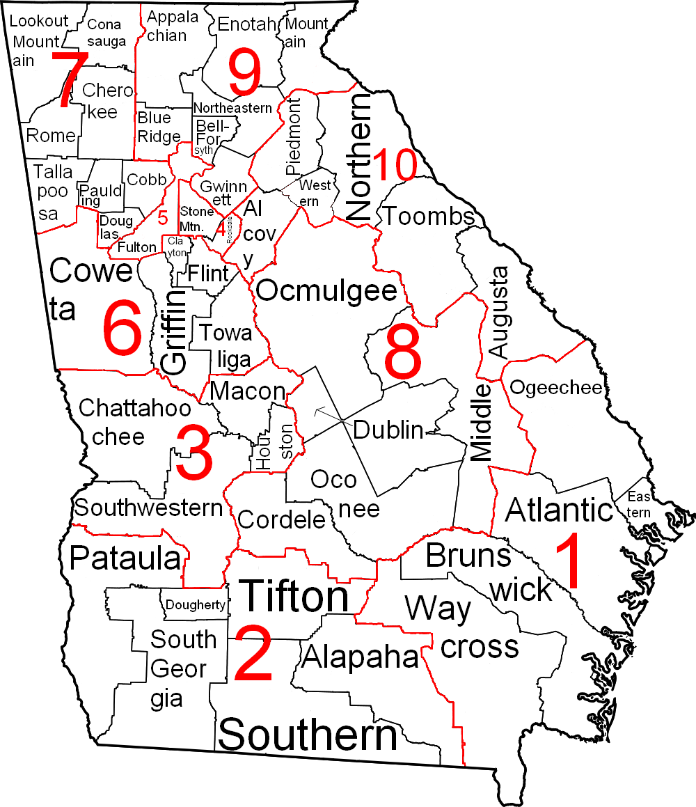
| DescriptionGeorgia judicial districts and circuits map.png |
English: This is a map of Georgia showing the judicial districts and circuits.
Legend: 1 Judicial District numberToombs Judicial Circuit nameEspañol: Este es un mapa de Georgia que muestra los distritos judiciales y los circuitos. Leyenda: 1 Número de Distrito JudicialToombs nombre del Circuito Judicial |
| Date | (UTC) |
| Source |
This file was derived from: Map of Georgia highlighting Oconee County.svg:  |
| Author |
|
| This is a retouched picture, which means that it has been digitally altered from its original version. Modifications: Removed colors, added lines, text, and numbers. The original can be viewed here: Map of Georgia highlighting Oconee County.svg:
|
Licensing
I, the copyright holder of this work, hereby publish it under the following license:
| Public domainPublic domainfalsefalse |
| I, the copyright holder of this work, release this work into the public domain. This applies worldwide. In some countries this may not be legally possible; if so: I grant anyone the right to use this work for any purpose, without any conditions, unless such conditions are required by law. |
Original upload log
This image is a derivative work of the following images:
- File:Map_of_Georgia_highlighting_Oconee_County.svg licensed with PD-self
- 2006-02-12T11:02:57Z David Benbennick 4437x5142 (442841 Bytes) {{subst:User:Dbenbenn/clm|county=Oconee County|state=Georgia}}
Uploaded with derivativeFX
Captions
Add a one-line explanation of what this file represents
Items portrayed in this file
depicts
4 April 2012
File history
Click on a date/time to view the file as it appeared at that time.
| Date/Time | Thumbnail | Dimensions | User | Comment | |
|---|---|---|---|---|---|
| current | 15:32, 4 April 2012 | | 1,000 × 1,159 (228 KB) | Presidentman | == {{int:filedesc}} == {{Information |Description=This is a map of Georgia showing the judicial districts and circuits. |Source={{Derived from|Map_of_Georgia_highlighting_Oconee_County.svg|display=50}} |Date=2012-04-04 15:29 ... |
File usage
The following pages on the English Wikipedia use this file (pages on other projects are not listed):
Global file usage
The following other wikis use this file:
- Usage on ar.wikipedia.org
Metadata
This file contains additional information, probably added from the digital camera or scanner used to create or digitize it.
If the file has been modified from its original state, some details may not fully reflect the modified file.
| Software used |
|---|