File:Galveston_island_0001.png
From Wikipedia, the free encyclopedia
No higher resolution available.
Galveston_island_0001.png (534 × 566 pixels, file size: 34 KB, MIME type: image/png)
| This is a file from the Wikimedia Commons. Information from its description page there is shown below. Commons is a freely licensed media file repository. You can help. |
Summary
| DescriptionGalveston island 0001.png |
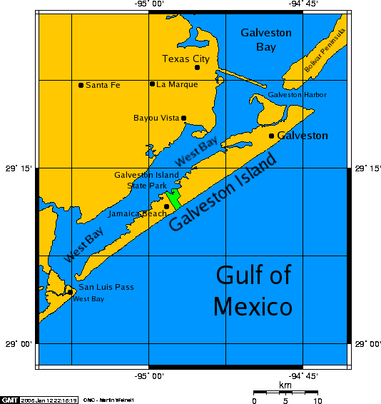
English: A map of Galveston Island, a barrier island on Galveston Bay of the Gulf Coast of Texas.
|
| Date | 12 January 2006 (original upload date) |
| Source | Transfered from en.wikipedia Transfer was stated to be made by User:PaulVIF. |
| Author | Original uploader was Kharker at en.wikipedia |
| Permission (Reusing this file) |
GFDL-SELF-WITH-DISCLAIMERS; Released under the GNU Free Documentation License. |
Licensing

|
Permission is granted to copy, distribute and/or modify this document under the terms of the GNU Free Documentation License, Version 1.2 or any later version published by the Free Software Foundation; with no Invariant Sections, no Front-Cover Texts, and no Back-Cover Texts. A copy of the license is included in the section entitled GNU Free Documentation License.http://www.gnu.org/copyleft/fdl.htmlGFDLGNU Free Documentation Licensetruetrue |
| This file is licensed under the Creative Commons Attribution-Share Alike 3.0 Unported license. | ||
| ||
| This licensing tag was added to this file as part of the GFDL licensing update.http://creativecommons.org/licenses/by-sa/3.0/CC BY-SA 3.0Creative Commons Attribution-Share Alike 3.0truetrue |
I, the copyright holder of this work, hereby publish it under the following license:

|
Permission is granted to copy, distribute and/or modify this document under the terms of the GNU Free Documentation License, Version 1.2 or any later version published by the Free Software Foundation; with no Invariant Sections, no Front-Cover Texts, and no Back-Cover Texts. A copy of the license is included in the section entitled GNU Free Documentation License. Subject to disclaimers.http://www.gnu.org/copyleft/fdl.htmlGFDLGNU Free Documentation Licensetruetrue |
Original upload log
The original description page was here. All following user names refer to en.wikipedia.
- 2006-01-12 21:50 Kharker 534×566×8 (34675 bytes) A map of [[Galveston Island]], a [[barrier island]] on the [[Texas]] Gulf coast in the [[United States]], about 50 miles (80 kilometers) south of the city of [[Houston, Texas|Houston]]. The map was created with this [http://www.aquarius.geomar.de/omc/ on
Captions
Add a one-line explanation of what this file represents
Items portrayed in this file
depicts
12 January 2006
image/png
File history
Click on a date/time to view the file as it appeared at that time.
| Date/Time | Thumbnail | Dimensions | User | Comment | |
|---|---|---|---|---|---|
| current | 10:07, 22 December 2007 | | 534 × 566 (34 KB) | PaulVIF | {{Information |Description={{en|A map of en:Galveston Island, a en:barrier island on the en:Texas Gulf coast in the en:United States, about 50 miles (80 kilometers) south of the city of Houston. The map was crea |
File usage
The following pages on the English Wikipedia use this file (pages on other projects are not listed):
Global file usage
The following other wikis use this file:
- Usage on arz.wikipedia.org
- Usage on de.wikipedia.org
- Usage on es.wikipedia.org
- Usage on eu.wikipedia.org
- Usage on fr.wikipedia.org
- Usage on fr.wiktionary.org
- Usage on id.wikipedia.org
- Usage on it.wikipedia.org
- Usage on pt.wikipedia.org
- Usage on ru.wikipedia.org
- Usage on simple.wikipedia.org
- Usage on www.wikidata.org
- Usage on zh.wikipedia.org
Retrieved from "https://en.wikipedia.org/wiki/File:Galveston_island_0001.png"