File:FirstMap-ChristmasIsland.jpg
From Wikipedia, the free encyclopedia
No higher resolution available.
FirstMap-ChristmasIsland.jpg (460 × 452 pixels, file size: 201 KB, MIME type: image/jpeg)
| This is a file from the Wikimedia Commons. Information from its description page there is shown below. Commons is a freely licensed media file repository. You can help. |
| This image appeared on Wikipedia's Main Page in the Did you know? column on 6 May 2013 (see archives). |
Summary
| DescriptionFirstMap-ChristmasIsland.jpg |
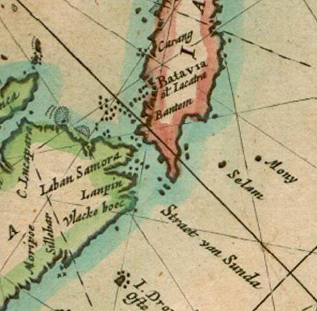
English: A part of Dutchman Pieter Goos' map of the East Indies (Paskaerte zynde t'oosterdeel van Oost Indien: met alle de eylanden deer ontrendt geleegen van C. Comorin tot aen Iapan). This small section of the map shows the location of Mony, now called Christmas Island. It is the first time Christmas Island appears on a map. |
|||||||||||||||||||
| Date | ||||||||||||||||||||
| Source | Map of the East Indies, by Pieter Goos (Paskaerte zynde t'oosterdeel van Oost Indien: met alle de eylanden deer ontrendt geleegen van C. Comorin tot aen Iapan). | |||||||||||||||||||
| Author |
creator QS:P170,Q3001923 |
|||||||||||||||||||
| Permission (Reusing this file) |
Public Domain | |||||||||||||||||||
| Other versions | http://commons.wikimedia.org/wiki/File:MapEastIndian-PieterGoos.jpg | |||||||||||||||||||
Licensing
| Public domainPublic domainfalsefalse |
|
This work is in the public domain in its country of origin and other countries and areas where the copyright term is the author's life plus 100 years or fewer. | |
| This file has been identified as being free of known restrictions under copyright law, including all related and neighboring rights. | |
https://creativecommons.org/publicdomain/mark/1.0/PDMCreative Commons Public Domain Mark 1.0falsefalse
Captions
Add a one-line explanation of what this file represents
Items portrayed in this file
depicts
1666
206,057 byte
452 pixel
460 pixel
image/jpeg
c125b362469b64925c36eba2a2823160febc84d4
File history
Click on a date/time to view the file as it appeared at that time.
| Date/Time | Thumbnail | Dimensions | User | Comment | |
|---|---|---|---|---|---|
| current | 09:39, 3 October 2009 | | 460 × 452 (201 KB) | Pmaas | {{Information |Description={{en|1=A part of Dutchman Pieter Goos' map of the East Indies (Paskaerte zynde t'oosterdeel van Oost Indien: met alle de eylanden deer ontrendt geleegen van C. Comorin tot aen Iapan). This small section of the map shows the loca |
File usage
The following pages on the English Wikipedia use this file (pages on other projects are not listed):
Metadata
This file contains additional information, probably added from the digital camera or scanner used to create or digitize it.
If the file has been modified from its original state, some details may not fully reflect the modified file.
| Orientation | Normal |
|---|---|
| Horizontal resolution | 96 dpi |
| Vertical resolution | 96 dpi |
| Software used | Adobe Photoshop CS Windows |
| File change date and time | 11:14, 3 October 2009 |
| Color space | Uncalibrated |