File:Europe_geological_map-fr.jpg
From Wikipedia, the free encyclopedia
Size of this preview: 589 × 599 pixels. Other resolutions: 236 × 240 pixels | 472 × 480 pixels | 755 × 768 pixels | 1,006 × 1,024 pixels | 2,012 × 2,048 pixels | 5,408 × 5,504 pixels.
Original file (5,408 × 5,504 pixels, file size: 7.03 MB, MIME type: image/jpeg)
| This is a file from the Wikimedia Commons. Information from its description page there is shown below. Commons is a freely licensed media file repository. You can help. |
Summary
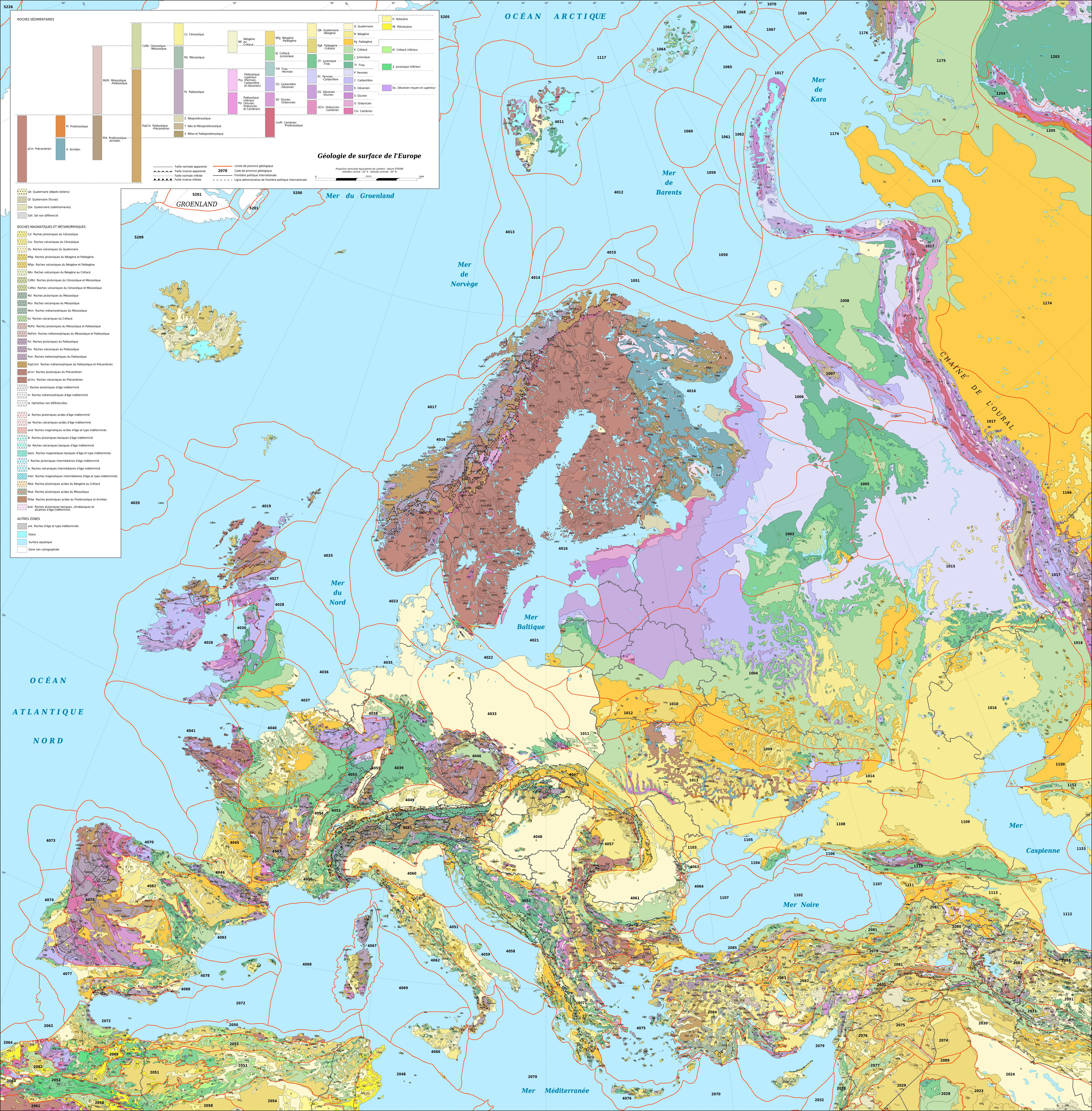
| DescriptionEurope geological map-fr.jpg |
English: Map in French of the surficial geology of Europe.
Note: For translations use the SVG version in English. A list of the names corresponding to the geologic provinces codes displayed on the map can be viewed on this page. Français : Carte en français de la géologie de surface de l'Europe.
Note : Pour les traductions utiliser la version SVG anglophone. Une liste des noms anglophones correspondant aux codes des provinces géologiques de la carte peut être consultée sur la cette page. Lambert Azimuthal Equal-Area projection - ETRS89 datum |
||
| Date | |||
| Source |
Own work
|
||
| Author | Eric Gaba (Sting - fr:Sting) | ||
| Permission (Reusing this file) |
|
||
| Other versions |
|


This map was improved or created by the Wikigraphists of the Graphic Lab (fr). You can propose images to clean up, improve, create or translate as well. |
Licensing
Eric Gaba, Wikimedia Commons user Sting, the copyright holder of this work, hereby publishes it under the following license:
This file is licensed under the Creative Commons Attribution-Share Alike 3.0 Unported license.
Attribution: Eric Gaba, Wikimedia Commons user Sting
- You are free:
- to share – to copy, distribute and transmit the work
- to remix – to adapt the work
- Under the following conditions:
- attribution – You must give appropriate credit, provide a link to the license, and indicate if changes were made. You may do so in any reasonable manner, but not in any way that suggests the licensor endorses you or your use.
- share alike – If you remix, transform, or build upon the material, you must distribute your contributions under the same or compatible license as the original.
Captions
Add a one-line explanation of what this file represents
Items portrayed in this file
depicts
August 2010
image/jpeg
File history
Click on a date/time to view the file as it appeared at that time.
| Date/Time | Thumbnail | Dimensions | User | Comment | |
|---|---|---|---|---|---|
| current | 18:27, 25 September 2019 | | 5,408 × 5,504 (7.03 MB) | Sting | Color profile |
| 18:00, 13 August 2010 |  | 5,408 × 5,504 (5.78 MB) | Sting | == {{int:filedesc}} == {{Location|60|00|00|N|20|00|00|E|scale:20000000}} <br/> {{Information| |Description={{en|Map in French of the surficial geology of Europe.<br/>''Note: For translations use the [[:File:Europe_geological_map- |
File usage
No pages on the English Wikipedia use this file (pages on other projects are not listed).
Global file usage
The following other wikis use this file:
- Usage on fr.wikipedia.org
- Usage on lv.wikipedia.org
Metadata
This file contains additional information, probably added from the digital camera or scanner used to create or digitize it.
If the file has been modified from its original state, some details may not fully reflect the modified file.
| Image title |
|
|---|---|
| Copyright holder |
|
| Width | 5,408 px |
| Height | 5,504 px |
| Bits per component |
|
| Pixel composition | RGB |
| Orientation | Normal |
| Number of components | 3 |
| Horizontal resolution | 72 dpi |
| Vertical resolution | 72 dpi |
| Software used | Adobe Photoshop CC 2019 (Windows) |
| File change date and time | 15:26, 25 September 2019 |
| Exif version | 2.31 |
| Color space | sRGB |
| Unique ID of original document | 0216B390543B909A84F5A885C7E854E4 |
| Date and time of digitizing | 12:25, 25 September 2019 |
| Date metadata was last modified | 12:26, 25 September 2019 |
| Copyright status | Copyrighted |
Retrieved from "https://en.wikipedia.org/wiki/File:Europe_geological_map-fr.jpg"