File:Cyprus_relief_location_map.jpg
From Wikipedia, the free encyclopedia
Original file (2,126 × 1,268 pixels, file size: 674 KB, MIME type: image/jpeg)
| This is a file from the Wikimedia Commons. Information from its description page there is shown below. Commons is a freely licensed media file repository. You can help. |
| DescriptionCyprus relief location map.jpg |
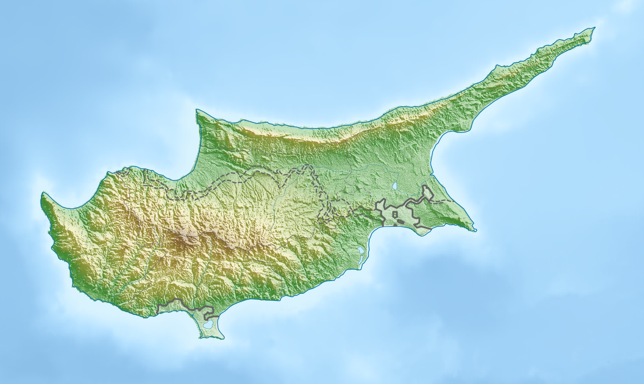
Deutsch: Physische Positionskarte von Zypern.
Quadratische Plattkarte, N-S-Streckung 115 %. Geographische Begrenzung der Karte:
English: Physical location map of Cyprus.
Equirectangular projection, N/S stretching 115 %. Geographic limits of the map:
|
| Date | |
| Source | Own work, using map data from administrative map by NordNordWest. The relief was created from SRTM-3 relief data |
| Author | Carport |
| Permission (Reusing this file) |
This file is licensed under the Creative Commons Attribution-Share Alike 3.0 Unported license.
|
| Other versions |
|

Captions
15 March 2010
image/jpeg
32fee7c31750a1702effe54993055e3172bdceaa
689,746 byte
1,268 pixel
2,126 pixel
File history
Click on a date/time to view the file as it appeared at that time.
| Date/Time | Thumbnail | Dimensions | User | Comment | |
|---|---|---|---|---|---|
| current | 17:26, 15 March 2010 | | 2,126 × 1,268 (674 KB) | Carport | {{Information |Description={{de|Physische Positionskarte von {{w|Zypern|3=de}}}} Quadratische Plattkarte, N-S-Streckung 115 %. Geographische Begrenzung der Karte: * N: 35.8° N * S: 34.4° N * W: 32.1° O * O: 34.8° O {{en|Physical location map of {{w|Cy |
File usage
More than 100 pages use this file. The following list shows the first 100 pages that use this file only. A full list is available.
- Achna
- Aetokremnos
- Agios Athanasios, Cyprus
- Agios Mamas, Limassol
- Agros, Cyprus
- Akaki, Cyprus
- Antiphonitis
- Arsos, Larnaca
- Askas
- Astromeritis
- Avdimou
- Ayios Dhometios
- Chandria
- Coral Bay, Cyprus
- Cyprus Police
- Dali, Cyprus
- Deryneia
- Dromolaxia
- Empa, Cyprus
- Enkomi
- Episkopi, Limassol
- Evretou Dam
- Evrychou
- Foini
- Frenaros
- Galata, Cyprus
- Galini, Cyprus
- Germasogeia
- Gialousa
- Kakopetria
- Kaliana
- Kapilio
- Kato Deftera
- Kato Drys
- Kato Platres
- Kato Pyrgos
- Kissonerga
- Kiti, Cyprus
- Kokkina
- Kokkinotrimithia
- Kolossi
- Kotsiatis
- Kouklia
- Kyperounta
- Kythrea
- Lakatamia
- Laneia
- Lapithos
- Larnaca Salt Lake
- Latsia
- Lefka
- Lefkoniko
- Lempa, Cyprus
- Limassol
- Limassol Salt Lake
- Limnitis
- Louroujina
- Lympia
- Lythrodontas
- Mammari
- Mathiatis
- Mesa Geitonia
- Morphou
- Mount Olympus (Cyprus)
- Moutoullas
- Nicosia
- Nikitari
- Nissi Beach
- Oroklini
- Painted Churches in the Troodos Region
- Paliometocho
- Pano Deftera
- Pano Lefkara
- Pano Panagia
- Paramytha
- Pegeia
- Pera Chorio
- Pera Orinis
- Peristerona
- Petra, Cyprus
- Platres
- Polis, Cyprus
- Politiko
- Potami
- Potamia, Cyprus
- Prastio, Famagusta
- Prodromos, Cyprus
- Pyla
- Pyrogi
- RAF Akrotiri
- Rizokarpaso
- Syrianochori
- Tala, Cyprus
- Tombs of the Kings (Paphos)
- Trachoni, Limassol
- Treis Elies
- Trikomo, Cyprus
- Tsada
- Tseri
- Tymbou
View more links to this file.
Global file usage
The following other wikis use this file:
- Usage on als.wikipedia.org
- Usage on ar.wikipedia.org
- Usage on arz.wikipedia.org
- Usage on av.wikipedia.org
- Usage on azb.wikipedia.org
- Usage on az.wikipedia.org
- Usage on ba.wikipedia.org
- Usage on be-tarask.wikipedia.org
- Usage on be.wikipedia.org
- Usage on bn.wikipedia.org
- Usage on bs.wikipedia.org
- Usage on ceb.wikipedia.org
- Usage on ce.wikipedia.org
- Usage on ckb.wikipedia.org
- Usage on cs.wikipedia.org
- Usage on cv.wikipedia.org
- Usage on da.wikipedia.org
- Usage on de.wikipedia.org
- Usage on de.wikivoyage.org
View more global usage of this file.
Metadata
This file contains additional information, probably added from the digital camera or scanner used to create or digitize it.
If the file has been modified from its original state, some details may not fully reflect the modified file.
| _error | 0 |
|---|