File:County_Lock_in_flood,_Reading.jpg
From Wikipedia, the free encyclopedia
No higher resolution available.
County_Lock_in_flood,_Reading.jpg (640 × 480 pixels, file size: 152 KB, MIME type: image/jpeg)
| This is a file from the Wikimedia Commons. Information from its description page there is shown below. Commons is a freely licensed media file repository. You can help. |
Summary
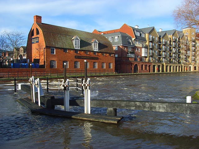
| DescriptionCounty Lock in flood, Reading.jpg | County Lock and Weir, on the River Kennet in Reading, England. The river is in a state of flood, and the lower lock gates seen here have been overtopped. The attractive brick building in the background is the former stable block of Simonds' Brewery, now a Loch Fyne restaurant. For more information see the Wikipedia article County Lock. |
| Date | Taken on 16 January 2008 |
| Source | www.geograph.org.uk. |
| Author | Andrew Smith. |
| Permission (Reusing this file) |
Published under Creative Commons Attribution-Sharealike 2.0. |
| Camera location | 51° 27′ 04.08″ N, 0° 58′ 25.96″ W | View this and other nearby images on: OpenStreetMap |
|---|
Licensing

|
This image was taken from the Geograph project collection. See this photograph's page on the Geograph website for the photographer's contact details. The copyright on this image is owned by Andrew Smith and is licensed for reuse under the Creative Commons Attribution-ShareAlike 2.0 license.
|
This file is licensed under the Creative Commons Attribution-Share Alike 2.0 Generic license.
Attribution: Andrew Smith
- You are free:
- to share – to copy, distribute and transmit the work
- to remix – to adapt the work
- Under the following conditions:
- attribution – You must give appropriate credit, provide a link to the license, and indicate if changes were made. You may do so in any reasonable manner, but not in any way that suggests the licensor endorses you or your use.
- share alike – If you remix, transform, or build upon the material, you must distribute your contributions under the same or compatible license as the original.
Captions
Add a one-line explanation of what this file represents
Items portrayed in this file
depicts
16 January 2008
51°27'4.075"N, 0°58'25.957"W
image/jpeg
0e26fa6eae472df26abea0163a01a4c696182153
155,975 byte
480 pixel
640 pixel
File history
Click on a date/time to view the file as it appeared at that time.
| Date/Time | Thumbnail | Dimensions | User | Comment | |
|---|---|---|---|---|---|
| current | 18:41, 11 February 2008 | | 640 × 480 (152 KB) | Chris j wood | ==Summary== {{Information| |Description = County Lock and Weir, on the River Kennet in Reading, England. The river is in a state of flood, and the lower lock gates seen here have been overtopped. The attractive brick building in the background is the form |
File usage
The following pages on the English Wikipedia use this file (pages on other projects are not listed):
Global file usage
The following other wikis use this file:
- Usage on fr.wikipedia.org
- Usage on sw.wikipedia.org
Metadata
This file contains additional information, probably added from the digital camera or scanner used to create or digitize it.
If the file has been modified from its original state, some details may not fully reflect the modified file.
| Camera manufacturer | RICOH |
|---|---|
| Camera model | Caplio R4 |
| Copyright holder | (C) by Caplio R4 User |
| Exposure time | 1/710 sec (0.0014084507042254) |
| F-number | f/3.6 |
| ISO speed rating | 100 |
| Date and time of data generation | 14:21, 16 January 2008 |
| Lens focal length | 5.2 mm |
| Orientation | Normal |
| Horizontal resolution | 72 dpi |
| Vertical resolution | 72 dpi |
| File change date and time | 14:21, 16 January 2008 |
| Y and C positioning | Co-sited |
| Exposure Program | Normal program |
| Exif version | 2.21 |
| Date and time of digitizing | 14:21, 16 January 2008 |
| Meaning of each component |
|
| Image compression mode | 2.8 |
| APEX aperture | 3.7 |
| APEX brightness | 6.3 |
| Exposure bias | 0 |
| Maximum land aperture | 3.3 APEX (f/3.14) |
| Metering mode | Pattern |
| Light source | Unknown |
| Flash | Flash did not fire, compulsory flash suppression |
| Supported Flashpix version | 1 |
| Color space | sRGB |
| Exposure mode | Auto exposure |
| White balance | Auto white balance |
| Scene capture type | Standard |
| Sharpness | Normal |
Retrieved from "https://en.wikipedia.org/wiki/File:County_Lock_in_flood,_Reading.jpg"