File:China-Yunnan.png
From Wikipedia, the free encyclopedia
No higher resolution available.
China-Yunnan.png (268 × 218 pixels, file size: 16 KB, MIME type: image/png)
| This is a file from the Wikimedia Commons. Information from its description page there is shown below. Commons is a freely licensed media file repository. You can help. |
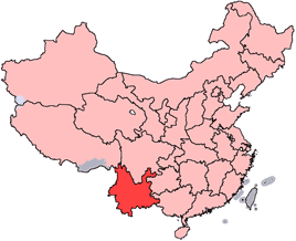
English: Location of Yunnan Province in the People's Republic of China. See Locator maps of province-level divisions of the People's Republic of China for more information.
中文:雲南省在中華人民共和國的位置。另見Locator maps of province-level divisions of the People's Republic of China。

|
Permission is granted to copy, distribute and/or modify this document under the terms of the GNU Free Documentation License, Version 1.2 or any later version published by the Free Software Foundation; with no Invariant Sections, no Front-Cover Texts, and no Back-Cover Texts. A copy of the license is included in the section entitled GNU Free Documentation License.http://www.gnu.org/copyleft/fdl.htmlGFDLGNU Free Documentation Licensetruetrue |
| This file is licensed under the Creative Commons Attribution-Share Alike 3.0 Unported license. | ||
| ||
| This licensing tag was added to this file as part of the GFDL licensing update.http://creativecommons.org/licenses/by-sa/3.0/CC BY-SA 3.0Creative Commons Attribution-Share Alike 3.0truetrue |

|
File:China Yunnan.svg is a vector version of this file. It should be used in place of this PNG file when not inferior.
File:China-Yunnan.png → File:China Yunnan.svg
For more information, see Help:SVG.
|
 |
Captions
Add a one-line explanation of what this file represents
Items portrayed in this file
depicts
image/png
335c9f8a3993413fa0ecf9f50a738c831c643829
16,401 byte
218 pixel
268 pixel
File history
Click on a date/time to view the file as it appeared at that time.
| Date/Time | Thumbnail | Dimensions | User | Comment | |
|---|---|---|---|---|---|
| current | 14:56, 15 July 2005 | | 268 × 218 (16 KB) | Schaengel89~commonswiki | transparent background |
| 22:38, 4 June 2005 |  | 268 × 218 (9 KB) | Ran | '''en''': Location of Yunnan Province in the People's Republic of China. See Category:Locator maps of province-level divisions of the People's Republic of China for more information. '''zh''': 雲南省在中華人民共和國的位置。另見[[:Ca |
File usage
More than 100 pages use this file. The following list shows the first 100 pages that use this file only. A full list is available.
- 1999 World Horticultural Exposition
- Ailao Mountains
- Anning, Yunnan
- Ba River (China)
- Binchuan County
- Cang Mountain
- Cangyuan Va Autonomous County
- Changning County, Yunnan
- Daguan County
- Dali Bai Autonomous Prefecture
- Dali Fengyi Airport
- Daxue Mountain
- Dayao County
- Dehong Mangshi International Airport
- Dianhong
- Diqing Shangri-La Airport
- Eryuan County
- Eshan Yi Autonomous County
- Fengqing County
- Fuyuan County, Yunnan
- Gengma Dai and Va Autonomous County
- Guandu, Kunming
- Gucheng, Lijiang
- Hekou Yao Autonomous County
- Heqing County
- Hongta, Yuxi
- Huize County
- Hutiaoxia Town
- Jade Water Village
- Jianchuan County
- Jiangchuan, Yuxi
- Jianshui County
- Jingdong Yi Autonomous County
- Jinggu Dai and Yi Autonomous County
- Kaiyuan, Yunnan
- Lincang Boshang Airport
- Linxiang, Lincang
- Longling County
- Longyang, Baoshan
- Lufeng, Yunnan
- Luliang County
- Luoping County
- Malong, Qujing
- Menglian Dai, Lahu and Va Autonomous County
- Midu County
- Mingyong Glacier
- Mojiang Hani Autonomous County
- Mouding County
- Nanhua County
- Nanjian Yi Autonomous County
- Ning'er Hani and Yi Autonomous County
- Ninglang Yi Autonomous County
- Nujiang Lisu Autonomous Prefecture
- Panlong River
- Panzhihua Township
- Pu'er Simao Airport
- Qiaojia County
- Qilin, Qujing
- Shidian County
- Shiping County
- Shizong County
- Shuangbai County
- Shuangjiang Lahu, Va, Blang and Dai Autonomous County
- Shuifu
- Songming County
- Suijiang County
- Tonghai County
- Weishan Yi and Hui Autonomous County
- Weixin County
- Wenshan Yanshan Airport
- Wuding County
- Wuhua, Kunming
- Xiaguan, Dali City
- Xiangyun County
- Ximeng Va Autonomous County
- Xinping Yi and Dai Autonomous County
- Xishan, Kunming
- Xishuangbanna Gasa International Airport
- Xuanwei
- Xundian Hui and Yi Autonomous County
- Yangbi Yi Autonomous County
- Yanjin County, Yunnan
- Yao'an County
- Yiliang County, Kunming
- Yiliang County, Zhaotong
- Yimen County
- Yiwu, Mengla County
- Yongde County
- Yongping County
- Yongren County
- Yongshan County
- Yongsheng County
- Yuanmou County
- Yulong Naxi Autonomous County
- Yun County, Yunnan
- Yun Range
- Zhanyi, Qujing
- Zhaotong Airport
- Zhaoyang, Zhaotong
- Zhenkang County
View more links to this file.
Global file usage
The following other wikis use this file:
- Usage on ca.wikipedia.org
- Usage on cs.wikipedia.org
- Usage on da.wikipedia.org
- Usage on de.wikipedia.org
- Mongolen
- Vietnamesen
- Tibeter
- Mandschu
- Han (Ethnie)
- Lijiang
- Naxi
- Kunming
- Mosuo
- Bai
- Hui-Chinesen
- Zhuang
- Xishuangbanna
- Dali (Autonomer Bezirk)
- Yao
- Yi (Volk)
- Bouyei (Volk)
- Dai (Volk)
- Sui (Volk)
- Hani
- Lisu
- Lahu
- Wa (Ethnie)
- Jingpo
- Blang
- Achang
- Jino
- De’ang
- Derung
- Primi
- Tu (Volk)
- Dehong
- Honghe
- Chuxiong
- Wenshan
- Dêqên
- Nujiang
- Nu (Volk)
- Pu’er
- Baoshan (Yunnan)
- Vorlage:Navigationsleiste Bezirksebene Yunnans
- Qujing
- Yuxi
- Zhaotong
- Lincang
- Khmu
- Miao
View more global usage of this file.
Retrieved from "https://en.wikipedia.org/wiki/File:China-Yunnan.png"