File:Catoctin_md_river_map.png
From Wikipedia, the free encyclopedia
Size of this preview: 512 × 600 pixels. Other resolutions: 205 × 240 pixels | 410 × 480 pixels | 656 × 768 pixels | 874 × 1,024 pixels | 1,500 × 1,757 pixels.
Original file (1,500 × 1,757 pixels, file size: 1.02 MB, MIME type: image/png)
| This is a file from the Wikimedia Commons. Information from its description page there is shown below. Commons is a freely licensed media file repository. You can help. |
Summary
| DescriptionCatoctin md river map.png |
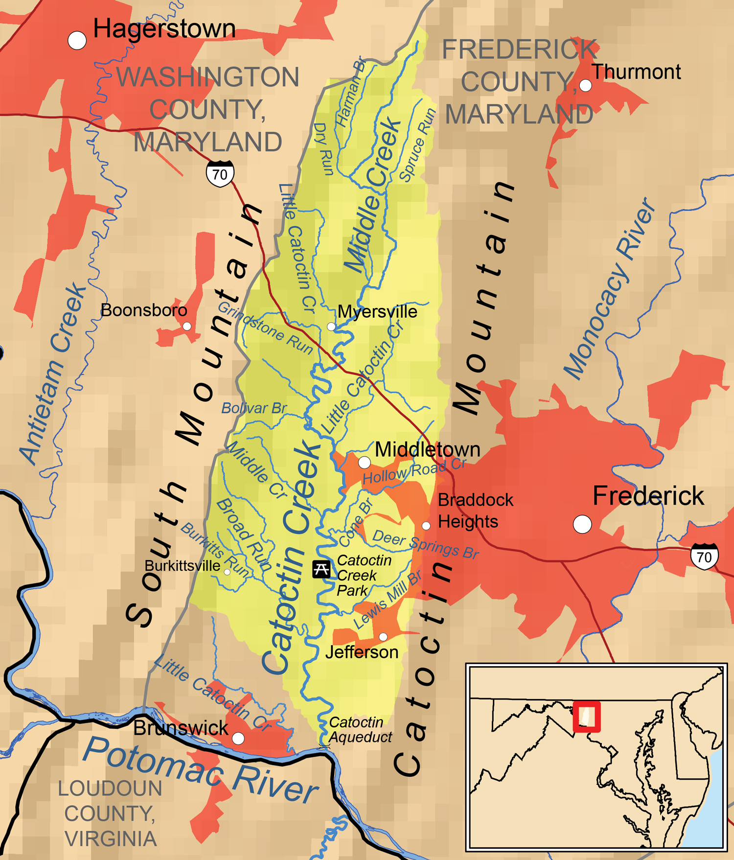
English: Map of the Tuscarora Creek (Potomac River) drainage basin. The drainage basin is in yellow. Urbanized areas are in red. |
| Date | |
| Source | Own work, hydrography data from the National Hydrography Dataset, roads from the National Highway Planning Network, urban areas from the U.S. Census, all other data from the National Atlas. USGS topographic maps used for reference. |
| Author | Kmusser |
Licensing
I, the copyright holder of this work, hereby publish it under the following license:
This file is licensed under the Creative Commons Attribution-Share Alike 3.0 Unported license.
- You are free:
- to share – to copy, distribute and transmit the work
- to remix – to adapt the work
- Under the following conditions:
- attribution – You must give appropriate credit, provide a link to the license, and indicate if changes were made. You may do so in any reasonable manner, but not in any way that suggests the licensor endorses you or your use.
- share alike – If you remix, transform, or build upon the material, you must distribute your contributions under the same or compatible license as the original.
Captions
Add a one-line explanation of what this file represents
Items portrayed in this file
depicts
15 June 2013
image/png
75951719fe0acf0e56291f2660540ed90d06f001
1,069,009 byte
1,757 pixel
1,500 pixel
File history
Click on a date/time to view the file as it appeared at that time.
| Date/Time | Thumbnail | Dimensions | User | Comment | |
|---|---|---|---|---|---|
| current | 00:45, 16 June 2013 | | 1,500 × 1,757 (1.02 MB) | Kmusser | User created page with UploadWizard |
File usage
The following pages on the English Wikipedia use this file (pages on other projects are not listed):
Metadata
This file contains additional information, probably added from the digital camera or scanner used to create or digitize it.
If the file has been modified from its original state, some details may not fully reflect the modified file.
| Unique ID of original document | xmp.did:F219B3BFCDD5E21186A28A0A29C1F552 |
|---|---|
| Software used |
Retrieved from "https://en.wikipedia.org/wiki/File:Catoctin_md_river_map.png"