File:CarthageMap.png
From Wikipedia, the free encyclopedia
No higher resolution available.
CarthageMap.png (770 × 447 pixels, file size: 106 KB, MIME type: image/png)
| This is a file from the Wikimedia Commons. Information from its description page there is shown below. Commons is a freely licensed media file repository. You can help. |
Summary
| DescriptionCarthageMap.png |
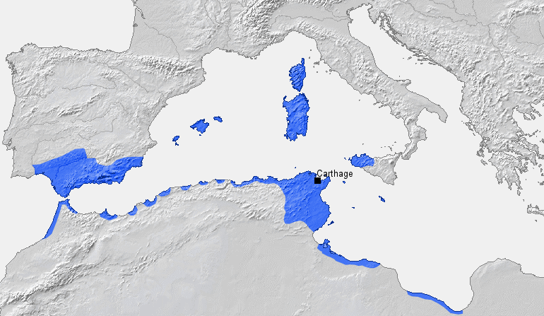
Location of Carthage and Carthaginian sphere of influence prior to the First Punic War (264 BC) Source: Self-made, based on Putzger Atlas und Chronik zur Weltgeschichte, Berlin, 2002 Template: [1] Author: BishkekRocks |
||
| Date | 18 March 2006 (original upload date) | ||
| Source | No machine-readable source provided. Own work assumed (based on copyright claims). | ||
| Author | No machine-readable author provided. BishkekRocks assumed (based on copyright claims). | ||
| Other versions |
|

Licensing
| Public domainPublic domainfalsefalse |
| I, the copyright holder of this work, release this work into the public domain. This applies worldwide. In some countries this may not be legally possible; if so: I grant anyone the right to use this work for any purpose, without any conditions, unless such conditions are required by law. |
Captions
Add a one-line explanation of what this file represents
Mapa de Cartago e seus vassalos em 264 a.C.
Kartaca
Items portrayed in this file
depicts
18 March 2006
image/png
a21d224da46fb69e1a697c8a0f9f5ff362c860d3
108,389 byte
447 pixel
770 pixel
File history
Click on a date/time to view the file as it appeared at that time.
| Date/Time | Thumbnail | Dimensions | User | Comment | |
|---|---|---|---|---|---|
| current | 19:50, 6 April 2023 | | 770 × 447 (106 KB) | Titanjs | Reverted to version as of 15:31, 18 March 2006 (UTC) |
| 14:16, 23 March 2016 |  | 770 × 447 (288 KB) | Michczu | drobna poprawka | |
| 16:52, 19 September 2014 |  | 770 × 447 (128 KB) | Daygum | True areas occupied by chartaginians | |
| 15:31, 18 March 2006 |  | 770 × 447 (106 KB) | BishkekRocks | Location of Carthage and Carthaginian influence sphere before the First Punic War (264 BC) Source: Self-made, based on Putzger Atlas und Chronik zur Weltgeschichte, Berlin, 2002 Template: [http://www.demis.nl/wms/mapclip.htm] Author: ~~~ [[Category:Ca |
File usage
The following pages on the English Wikipedia use this file (pages on other projects are not listed):
Global file usage
The following other wikis use this file:
- Usage on ar.wikipedia.org
- Usage on ast.wikipedia.org
- Usage on azb.wikipedia.org
- Usage on az.wikipedia.org
- Usage on ba.wikipedia.org
- Usage on be-tarask.wikipedia.org
- Usage on bg.wikipedia.org
- Usage on bm.wikipedia.org
- Usage on br.wikipedia.org
- Usage on bs.wikipedia.org
- Usage on ca.wikipedia.org
- Usage on cdo.wikipedia.org
- Usage on cs.wikipedia.org
- Usage on de.wikipedia.org
- Usage on el.wikipedia.org
- Usage on eo.wikipedia.org
- Usage on es.wikipedia.org
- Usage on et.wikipedia.org
- Usage on eu.wikipedia.org
View more global usage of this file.
Metadata
This file contains additional information, probably added from the digital camera or scanner used to create or digitize it.
If the file has been modified from its original state, some details may not fully reflect the modified file.
| Date and time of digitizing |
|
|---|---|
| File change date and time | 15:24, 18 March 2006 |
| Horizontal resolution | 28.34 dpc |
| Vertical resolution | 28.34 dpc |
Retrieved from "https://en.wikipedia.org/wiki/File:CarthageMap.png"