File:Cape_Verde-CIA_WFB_Map.png
From Wikipedia, the free encyclopedia
No higher resolution available.
Cape_Verde-CIA_WFB_Map.png (330 × 355 pixels, file size: 8 KB, MIME type: image/png)
| This is a file from the Wikimedia Commons. Information from its description page there is shown below. Commons is a freely licensed media file repository. You can help. |
| DescriptionCape Verde-CIA WFB Map.png |
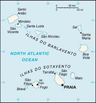
English: A map of the Republic of Cabo Verde, showing major cities. |
||||
| Date | published 2004 | ||||
| Source | CIA, The World Factbook, 2004. | ||||
| Author | CIA | ||||
| Permission (Reusing this file) |
|

| This file is an original and may be obsolete for general use, but is kept for historical or archival use. As such, it should not be modified or deleted except to correct upload or technical errors. Any modified versions or replacements of this image should be uploaded with a different file name. Information about this file: 2004 version العربيَّة ∙ čeština ∙ Deutsch ∙ English ∙ español ∙ فارسی ∙ français ∙ magyar ∙ italiano ∙ 日本語 ∙ Lëtzebuergesch ∙ македонски ∙ മലയാളം ∙ Nederlands ∙ português ∙ русский ∙ slovenščina ∙ svenska ∙ 简体中文 ∙ 繁體中文 ∙ 正體中文(臺灣) ∙ +/− |
Captions
Add a one-line explanation of what this file represents
Items portrayed in this file
depicts
image/png
332a5a1c2cb54764525ab04722ba541ce1c1f96a
7,918 byte
355 pixel
330 pixel
File history
Click on a date/time to view the file as it appeared at that time.
| Date/Time | Thumbnail | Dimensions | User | Comment | |
|---|---|---|---|---|---|
| current | 09:12, 27 March 2005 | | 330 × 355 (8 KB) | Wolfman~commonswiki | {{CIA-map}} |
File usage
The following pages on the English Wikipedia use this file (pages on other projects are not listed):
Global file usage
The following other wikis use this file:
- Usage on bh.wikipedia.org
- Usage on bs.wikipedia.org
- Usage on ca.wikipedia.org
- Santiago (Cap Verd)
- Illa de Sal
- Rabo de Junco
- Llista d'illes de Cap Verd
- Illa de Santo Antão
- Plantilla:Illes Cap Verd
- Illes de Barlavento
- Illes de Sotavento
- Illa de São Vicente
- Illa de Santa Luzia
- Ilhéu Branco
- Ilhéu Raso
- Illa de São Nicolau
- Illa de Boa Vista
- Ilhéu dos Pássaros
- Illa Brava
- Illa de Fogo
- Illa de Maio
- Ilhéu do Baluarte
- Ilhéu Laje Branca
- Ilhéu de Sal Rei
- Ilhéu de Santa Maria
- Ilhéus Secos
- Ilhéu Grande
- Ilhéu de Cima
- Mòdul:Location map/data/Cap Verd
- Mòdul:Location map/data/Cap Verd/ús
- Usage on de.wikipedia.org
- Usage on en.wikisource.org
- Usage on fa.wikipedia.org
- Usage on hi.wikipedia.org
- Usage on id.wikipedia.org
- Usage on ilo.wikipedia.org
- Usage on ja.wikipedia.org
- Usage on kn.wikipedia.org
- Usage on lt.wiktionary.org
- Usage on ml.wikipedia.org
- Usage on mr.wikipedia.org
- Usage on ru.wikipedia.org
- Usage on simple.wikipedia.org
View more global usage of this file.
Retrieved from "https://en.wikipedia.org/wiki/File:Cape_Verde-CIA_WFB_Map.png"