File:Calvert_Jubilee_Nature_Reserve_-_geograph.org.uk_-_431563.jpg
From Wikipedia, the free encyclopedia
No higher resolution available.
Calvert_Jubilee_Nature_Reserve_-_geograph.org.uk_-_431563.jpg (640 × 480 pixels, file size: 95 KB, MIME type: image/jpeg)
| This is a file from the Wikimedia Commons. Information from its description page there is shown below. Commons is a freely licensed media file repository. You can help. |
Summary
| DescriptionCalvert Jubilee Nature Reserve - geograph.org.uk - 431563.jpg |
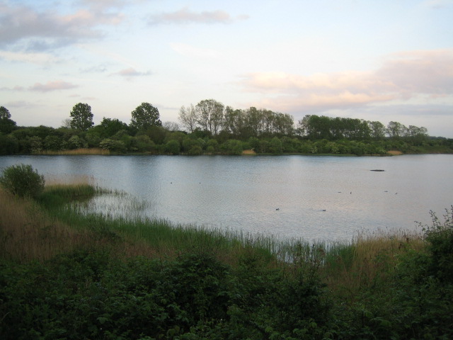
English: Calvert Jubilee Nature Reserve This nature reserve which opened in 1978 was once an old extraction pit for clay used locally for brick manufacture. Over the last 50 years, the 200 hectare standing open water habitat has become a haven for large numbers of over-wintering wildfowl and waders. The reed beds provide ideal habitat for the scarcely seen bittern, and the nutrient poor clay-capped land around the lake provides the right conditions for wildflowers and good numbers of rare butterflies including the grizzled and dingy skippers, http://www.ocv.org.uk/sites.php?id=14
The reserve is managed by the Berks, Bucks & Oxon Wildlife Trust, http://www.bbowt.org.uk/default.asp. |
| Date | |
| Source | From geograph.org.uk |
| Author | Andy Gryce |
| Attribution (required by the license) InfoField | Andy Gryce / Calvert Jubilee Nature Reserve / |
InfoField | Andy Gryce / Calvert Jubilee Nature Reserve |
| Camera location | 51° 55′ 16″ N, 1° 00′ 30″ W | View this and other nearby images on: OpenStreetMap |
|---|
| Object location | 51° 55′ 14″ N, 1° 00′ 24″ W | View this and other nearby images on: OpenStreetMap |
|---|
Licensing

|
This image was taken from the Geograph project collection. See this photograph's page on the Geograph website for the photographer's contact details. The copyright on this image is owned by Andy Gryce and is licensed for reuse under the Creative Commons Attribution-ShareAlike 2.0 license.
|
This file is licensed under the Creative Commons Attribution-Share Alike 2.0 Generic license.
Attribution: Andy Gryce
- You are free:
- to share – to copy, distribute and transmit the work
- to remix – to adapt the work
- Under the following conditions:
- attribution – You must give appropriate credit, provide a link to the license, and indicate if changes were made. You may do so in any reasonable manner, but not in any way that suggests the licensor endorses you or your use.
- share alike – If you remix, transform, or build upon the material, you must distribute your contributions under the same or compatible license as the original.
Captions
Add a one-line explanation of what this file represents
Items portrayed in this file
depicts
some value
12 May 2007
51°55'16.0"N, 1°0'29.9"W
51°55'14.27"N, 1°0'23.76"W
image/jpeg
0c273ad9c0398a58a88b33d8d7af424128f16392
97,341 byte
480 pixel
640 pixel
File history
Click on a date/time to view the file as it appeared at that time.
| Date/Time | Thumbnail | Dimensions | User | Comment | |
|---|---|---|---|---|---|
| current | 07:17, 4 February 2011 | | 640 × 480 (95 KB) | GeographBot | == {{int:filedesc}} == {{Information |description={{en|1=Calvert Jubilee Nature Reserve This nature reserve which opened in 1978 was once an old extraction pit for clay used locally for brick manufacture. Over the last 50 years, the 200 hectare standing o |
File usage
The following pages on the English Wikipedia use this file (pages on other projects are not listed):
Metadata
This file contains additional information, probably added from the digital camera or scanner used to create or digitize it.
If the file has been modified from its original state, some details may not fully reflect the modified file.
| Camera manufacturer | Canon |
|---|---|
| Camera model | Canon DIGITAL IXUS 40 |
| Exposure time | 1/125 sec (0.008) |
| F-number | f/2.8 |
| Date and time of data generation | 19:27, 12 May 2007 |
| Lens focal length | 5.8 mm |
| Orientation | Normal |
| Horizontal resolution | 180 dpi |
| Vertical resolution | 180 dpi |
| File change date and time | 19:27, 12 May 2007 |
| Y and C positioning | Centered |
| Exif version | 2.2 |
| Date and time of digitizing | 19:27, 12 May 2007 |
| Image compression mode | 3 |
| Shutter speed | 6.96875 |
| APEX aperture | 2.96875 |
| Exposure bias | 0 |
| Maximum land aperture | 2.96875 APEX (f/2.8) |
| Metering mode | Pattern |
| Flash | Flash did not fire, auto mode |
| Color space | sRGB |
| Focal plane X resolution | 2,857.1428571429 |
| Focal plane Y resolution | 2,857.1428571429 |
| Focal plane resolution unit | inches |
| Sensing method | One-chip color area sensor |
| Custom image processing | Normal process |
| Exposure mode | Auto exposure |
| White balance | Auto white balance |
| Digital zoom ratio | 1 |
| Scene capture type | Standard |