File:CO_Mineral_Belt.jpg
From Wikipedia, the free encyclopedia
No higher resolution available.
CO_Mineral_Belt.jpg (453 × 321 pixels, file size: 35 KB, MIME type: image/jpeg)
| This is a file from the Wikimedia Commons. Information from its description page there is shown below. Commons is a freely licensed media file repository. You can help. |
Summary

|
This geology image could be re-created using vector graphics as an SVG file. This has several advantages; see Commons:Media for cleanup for more information. If an SVG form of this image is available, please upload it and afterwards replace this template with
{{vector version available|new image name}}.
It is recommended to name the SVG file “CO Mineral Belt.svg”—then the template Vector version available (or Vva) does not need the new image name parameter. |
 | This geology image was uploaded in the JPEG format even though it consists of non-photographic data. This information could be stored more efficiently or accurately in the PNG or SVG format. If possible, please upload a PNG or SVG version of this image without compression artifacts, derived from a non-JPEG source (or with existing artifacts removed). After doing so, please tag the JPEG version with {{Superseded|NewImage.ext}} and remove this tag. This tag should not be applied to photographs or scans. If this image is a diagram or other image suitable for vectorisation, please tag this image with {{Convert to SVG}} instead of {{BadJPEG}}. If not suitable for vectorisation, use {{Convert to PNG}}. For more information, see {{BadJPEG}}. |  |
| DescriptionCO Mineral Belt.jpg |
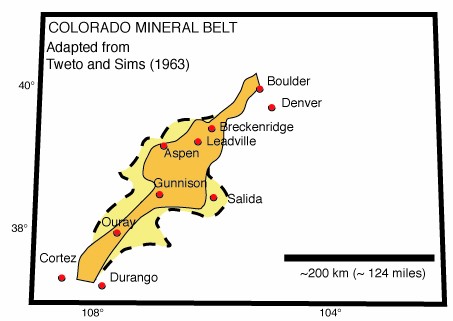
English: Outline of state of Colorado (USA) with approximate reproductions of the two versions of the Colorado Mineral Belt that were suggested by Tweto and Sims (Precambrian Ancestry of the Colorado Mineral Belt, Geological Society of America Bulletin 74, p. 991-1014, 1963). The principal mining districts of Laramide age are in the inner area bounded by solid lines and in a darker color. The "Maximum boundary" is shown by the dashed lines. |
| Source | Own work |
| Author | Omphacite |
Licensing
| Public domainPublic domainfalsefalse |
| I, the copyright holder of this work, release this work into the public domain. This applies worldwide. In some countries this may not be legally possible; if so: I grant anyone the right to use this work for any purpose, without any conditions, unless such conditions are required by law. |
Captions
Add a one-line explanation of what this file represents
Items portrayed in this file
depicts
image/jpeg
8ccbd5b1105f1d49b821552109e10d1d6b3d733a
35,710 byte
321 pixel
453 pixel
File history
Click on a date/time to view the file as it appeared at that time.
| Date/Time | Thumbnail | Dimensions | User | Comment | |
|---|---|---|---|---|---|
| current | 17:43, 6 July 2006 | | 453 × 321 (35 KB) | Raymond | saved new with GIMP |
| 01:53, 6 July 2006 |  | 453 × 321 (642 KB) | Omphacite~commonswiki | Own work: Outline of state of Colorado (USA) with approximate reproductions of the two versions of the Colorado Mineral Belt that were suggested by Tweto and Sims (Precambrian Ancestry of the Colorado Mineral Belt, Geological Society of America Bulletin 7 |
File usage
The following pages on the English Wikipedia use this file (pages on other projects are not listed):
Global file usage
The following other wikis use this file:
- Usage on es.wikipedia.org
- Usage on fr.wikipedia.org
- Usage on it.wikipedia.org
- Usage on tr.wikipedia.org
Metadata
This file contains additional information, probably added from the digital camera or scanner used to create or digitize it.
If the file has been modified from its original state, some details may not fully reflect the modified file.
| Orientation | Normal |
|---|---|
| Horizontal resolution | 72 dpi |
| Vertical resolution | 72 dpi |
| Software used | Adobe Photoshop 7.0 |
| File change date and time | 19:39, 5 July 2006 |
| Color space | Uncalibrated |
Retrieved from "https://en.wikipedia.org/wiki/File:CO_Mineral_Belt.jpg"