File:British_empire_1886.jpg
From Wikipedia, the free encyclopedia
Original file (1,500 × 1,122 pixels, file size: 625 KB, MIME type: image/jpeg)
| This is a file from the Wikimedia Commons. Information from its description page there is shown below. Commons is a freely licensed media file repository. You can help. |
Summary
| DescriptionBritish empire 1886.jpg |
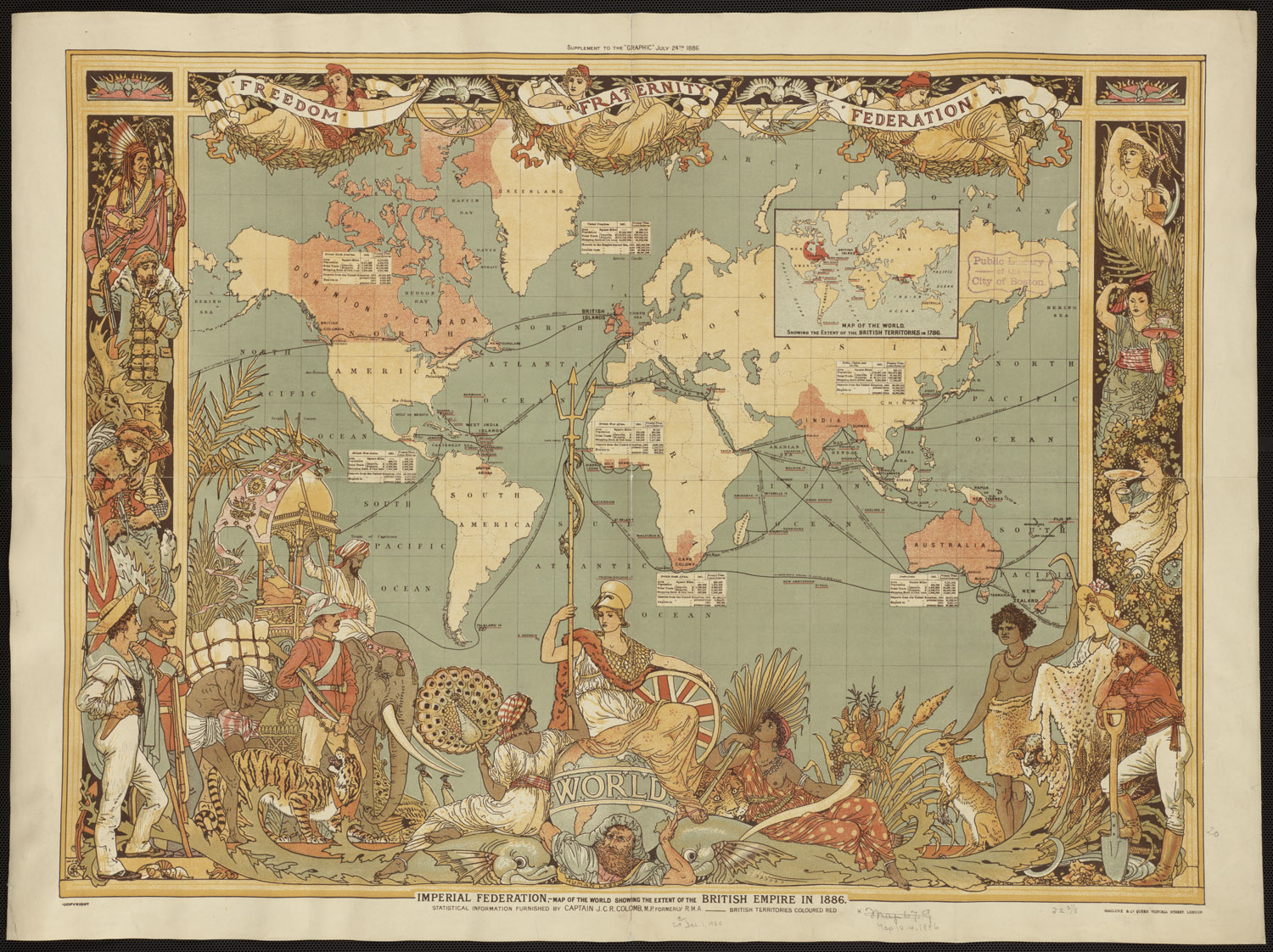
English: Map of the world showing the extent of the British Empire in 1886. British territories coloured in red. Published as a supplement for The Graphic, July 1886, as the "Imperial Federation". Statistical information furnished by Captain J.C.R. Colomb, M.P. formerly R.M.A. |
|||||||||||||||||||||||
| Date | ||||||||||||||||||||||||
| Source | https://www.flickr.com/photos/boston_public_library/4404528478/ | |||||||||||||||||||||||
| Author |
creator QS:P170,Q660917 |
|||||||||||||||||||||||
| Other versions |
|
|||||||||||||||||||||||


.jpg)
Licensing
| Public domainPublic domainfalsefalse |
|
This work is in the public domain in its country of origin and other countries and areas where the copyright term is the author's life plus 70 years or fewer. This work is in the public domain in the United States because it was published (or registered with the U.S. Copyright Office) before January 1, 1929. | |
| This file has been identified as being free of known restrictions under copyright law, including all related and neighboring rights. | |
https://creativecommons.org/publicdomain/mark/1.0/PDMCreative Commons Public Domain Mark 1.0falsefalse
Captions
Items portrayed in this file
depicts
24 July 1886Gregorian
image/jpeg
50d4f3074425eb4fbb7763de9b67d33a05261171
639,655 byte
1,122 pixel
1,500 pixel
File history
Click on a date/time to view the file as it appeared at that time.
| Date/Time | Thumbnail | Dimensions | User | Comment | |
|---|---|---|---|---|---|
| current | 02:25, 29 October 2010 | | 1,500 × 1,122 (625 KB) | Nikkimaria | higher-resolution version, from [http://www.flickr.com/photos/boston_public_library/4404528478/sizes/o/in/photostream/ flickr] |
| 23:02, 26 October 2010 |  | 1,051 × 794 (1.07 MB) | Nikkimaria | {{Information |Description={{en|1=Map of the world showing the extent of the British Empire in 1886. British territories coloured in red}} |Source=The Graphic July 1886, 'Imperial Federation' |Author=en:Walter Crane (d. 1915) |Date=1886 |Permission=se |
File usage
Global file usage
The following other wikis use this file:
- Usage on it.wikipedia.org
- Usage on ja.wikipedia.org
- Usage on nl.wikipedia.org
Metadata
This file contains additional information, probably added from the digital camera or scanner used to create or digitize it.
If the file has been modified from its original state, some details may not fully reflect the modified file.
| Width | 10,496 px |
|---|---|
| Height | 7,848 px |
| Compression scheme | Uncompressed |
| Pixel composition | RGB |
| Orientation | Normal |
| Number of components | 3 |
| Horizontal resolution | 300 dpi |
| Vertical resolution | 300 dpi |
| Data arrangement | chunky format |
| Software used | Adobe Photoshop CS3 Macintosh |
| File change date and time | 17:06, 10 February 2010 |
| Color space | Uncalibrated |