File:Brampton_Station_-_geograph.org.uk_-_1236379.jpg
From Wikipedia, the free encyclopedia
No higher resolution available.
Brampton_Station_-_geograph.org.uk_-_1236379.jpg (640 × 480 pixels, file size: 136 KB, MIME type: image/jpeg)
| This is a file from the Wikimedia Commons. Information from its description page there is shown below. Commons is a freely licensed media file repository. You can help. |
Summary
| DescriptionBrampton Station - geograph.org.uk - 1236379.jpg |
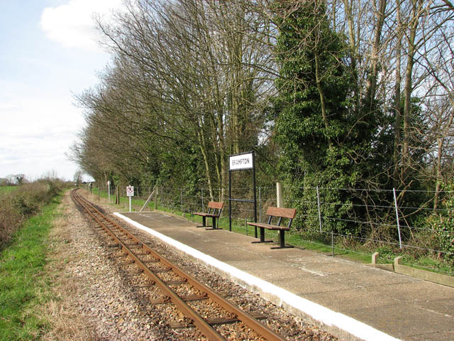
English: Brampton Station. One of the stations on the Bure Valley Railway, Norfolk's longest fifteen inch gauge line. It opened on 10. July 1990, and the long distance footpath running parallel with it was opened in 1991. The Bure Valley Railway runs between Aylsham and Wroxham, with stations in Brampton, Buxton and Coltishall. The railway operates services using either Steam or Diesel locomotives - ten buckets of coal are required for fuelling a steam locomotive on its 18 mile round trip > 761200. http://www.bvrw.co.uk/
The railway runs on the trackbed of the East Norfolk Railway (ENR), opened in 1877 with the first section connecting Norwich and Cromer, and an extension from Wroxham to Aylsham in 1880. The line was taken over by the Great Eastern Railway in 1882 and amalgamated into the London & North Eastern Railway in 1923. Passenger service stopped in 1952 but freight service continued until the 1970s. Coal traffic was carried from Norwich Thorpe via Aylsham to Norwich City and concrete building components were carried from Lenwade. This traffic ended in 1981 and the line through Aylsham formally closed on 6 January 1982. |
| Date | |
| Source | From geograph.org.uk |
| Author | Evelyn Simak |
| Attribution (required by the license) InfoField | Evelyn Simak / Brampton Station / |
InfoField | Evelyn Simak / Brampton Station |
| Camera location | 52° 46′ 00″ N, 1° 17′ 29″ E | View this and other nearby images on: OpenStreetMap |
|---|
| Object location | 52° 46′ 01″ N, 1° 17′ 28″ E | View this and other nearby images on: OpenStreetMap |
|---|
Licensing

|
This image was taken from the Geograph project collection. See this photograph's page on the Geograph website for the photographer's contact details. The copyright on this image is owned by Evelyn Simak and is licensed for reuse under the Creative Commons Attribution-ShareAlike 2.0 license.
|
This file is licensed under the Creative Commons Attribution-Share Alike 2.0 Generic license.
Attribution: Evelyn Simak
- You are free:
- to share – to copy, distribute and transmit the work
- to remix – to adapt the work
- Under the following conditions:
- attribution – You must give appropriate credit, provide a link to the license, and indicate if changes were made. You may do so in any reasonable manner, but not in any way that suggests the licensor endorses you or your use.
- share alike – If you remix, transform, or build upon the material, you must distribute your contributions under the same or compatible license as the original.
Captions
Add a one-line explanation of what this file represents
Items portrayed in this file
depicts
some value
5 April 2009
52°46'0.01"N, 1°17'29.04"E
52°46'1.34"N, 1°17'27.60"E
image/jpeg
954b68c9c9f0a9a0cdd946dc83666565c038e8d8
139,520 byte
480 pixel
640 pixel
File history
Click on a date/time to view the file as it appeared at that time.
| Date/Time | Thumbnail | Dimensions | User | Comment | |
|---|---|---|---|---|---|
| current | 12:38, 26 February 2011 | | 640 × 480 (136 KB) | GeographBot | == {{int:filedesc}} == {{Information |description={{en|1=Brampton Station One of the stations on the Bure Valley Railway, Norfolk's longest fifteen inch gauge line. It opened on 10. July 1990, and the long distance footpath running parallel with it was op |
File usage
The following pages on the English Wikipedia use this file (pages on other projects are not listed):
Global file usage
The following other wikis use this file:
- Usage on www.wikidata.org
Metadata
This file contains additional information, probably added from the digital camera or scanner used to create or digitize it.
If the file has been modified from its original state, some details may not fully reflect the modified file.
| Camera manufacturer | Canon |
|---|---|
| Camera model | Canon PowerShot S3 IS |
| Exposure time | 1/400 sec (0.0025) |
| F-number | f/4 |
| Date and time of data generation | 13:11, 5 April 2009 |
| Lens focal length | 6 mm |
| Orientation | Normal |
| Horizontal resolution | 180 dpi |
| Vertical resolution | 180 dpi |
| File change date and time | 16:19, 5 April 2009 |
| Y and C positioning | Centered |
| Software used | Adobe Photoshop CS Windows |
| Exif version | 2.2 |
| Date and time of digitizing | 13:11, 5 April 2009 |
| Image compression mode | 3 |
| Shutter speed | 8.65625 |
| APEX aperture | 4 |
| Exposure bias | 0 |
| Maximum land aperture | 2.875 APEX (f/2.71) |
| Metering mode | Pattern |
| Flash | Flash did not fire, compulsory flash suppression |
| Color space | sRGB |
| Focal plane X resolution | 10,097.777777778 |
| Focal plane Y resolution | 10,082.840236686 |
| Focal plane resolution unit | inches |
| Sensing method | One-chip color area sensor |
| Custom image processing | Normal process |
| Exposure mode | Auto exposure |
| White balance | Auto white balance |
| Digital zoom ratio | 1 |
| Scene capture type | Standard |