File:Battyeford_Station_site_of_1772802_e54962dd.jpg
From Wikipedia, the free encyclopedia
No higher resolution available.
Battyeford_Station_site_of_1772802_e54962dd.jpg (640 × 382 pixels, file size: 118 KB, MIME type: image/jpeg)
| This is a file from the Wikimedia Commons. Information from its description page there is shown below. Commons is a freely licensed media file repository. You can help. |
Summary
| DescriptionBattyeford Station site of 1772802 e54962dd.jpg |
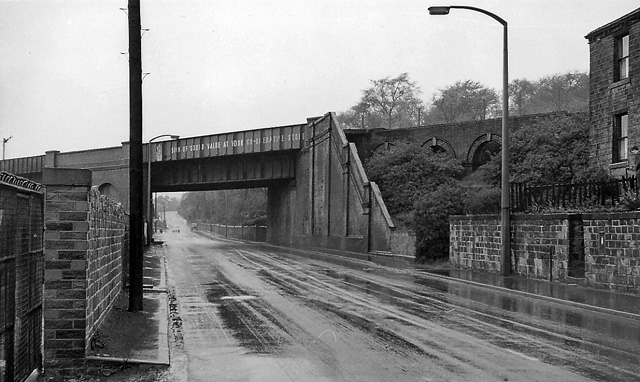
English: Site of Battyeford Station. Station had been up to right. View NW on A644 of bridge carrying ex-LNW 'Leeds New Line' (Spen Valley Junction - Franley Junction): Spen Valley Junction and Huddersfield to left, Farnley Junction and Leeds (City) to right. Station closed and local passenger services ceased 5/10/53, goods 2/8/65, through services continued until 11/1/66 when connection put in with ex-L&Y line at Heckmondwike. |
| Date | |
| Source | From geograph.org.uk |
| Author | Ben Brooksbank |
| Permission (Reusing this file) |
Creative Commons Attribution Share-alike license 2.0 |
| Camera location | 53° 40′ 39.79″ N, 1° 42′ 13.87″ W | View this and other nearby images on: OpenStreetMap |
|---|
Licensing

|
This image was taken from the Geograph project collection. See this photograph's page on the Geograph website for the photographer's contact details. The copyright on this image is owned by Ben Brooksbank and is licensed for reuse under the Creative Commons Attribution-ShareAlike 2.0 license.
|
This file is licensed under the Creative Commons Attribution-Share Alike 2.0 Generic license.
Attribution: Ben Brooksbank
- You are free:
- to share – to copy, distribute and transmit the work
- to remix – to adapt the work
- Under the following conditions:
- attribution – You must give appropriate credit, provide a link to the license, and indicate if changes were made. You may do so in any reasonable manner, but not in any way that suggests the licensor endorses you or your use.
- share alike – If you remix, transform, or build upon the material, you must distribute your contributions under the same or compatible license as the original.
Captions
Add a one-line explanation of what this file represents
Items portrayed in this file
depicts
some value
22 April 1961
53°40'39.792"N, 1°42'13.871"W
image/jpeg
335ccc5068e682568fb890792603fd55c9ebd499
121,027 byte
382 pixel
640 pixel
File history
Click on a date/time to view the file as it appeared at that time.
| Date/Time | Thumbnail | Dimensions | User | Comment | |
|---|---|---|---|---|---|
| current | 16:22, 26 January 2011 | | 640 × 382 (118 KB) | Belaro | == {{int:filedesc}} == {{Information |Description={{en|1=Site of Battyeford Station Station had been up to right. View NW on A644 of bridge carrying ex-LNW 'Leeds New Line' (Spen Valley Junction - Franley Junction): Spen Valley Junction and Huddersfield t |
File usage
The following pages on the English Wikipedia use this file (pages on other projects are not listed):
Global file usage
The following other wikis use this file:
- Usage on www.wikidata.org
Metadata
This file contains additional information, probably added from the digital camera or scanner used to create or digitize it.
If the file has been modified from its original state, some details may not fully reflect the modified file.
| Image title | EPSON scanner image |
|---|---|
| Orientation | Normal |
| Horizontal resolution | 78 dpc |
| Vertical resolution | 78 dpc |
| Software used | Adobe Photoshop Elements 3.0 Windows |
| File change date and time | 11:45, 27 March 2010 |
| Color space | Uncalibrated |