File:Bathymetric_map_of_Guam.jpg
From Wikipedia, the free encyclopedia
Size of this preview: 596 × 600 pixels. Other resolutions: 238 × 240 pixels | 477 × 480 pixels | 763 × 768 pixels | 1,018 × 1,024 pixels | 2,058 × 2,071 pixels.
Original file (2,058 × 2,071 pixels, file size: 367 KB, MIME type: image/jpeg)
| This is a file from the Wikimedia Commons. Information from its description page there is shown below. Commons is a freely licensed media file repository. You can help. |
Summary
| DescriptionBathymetric map of Guam.jpg |
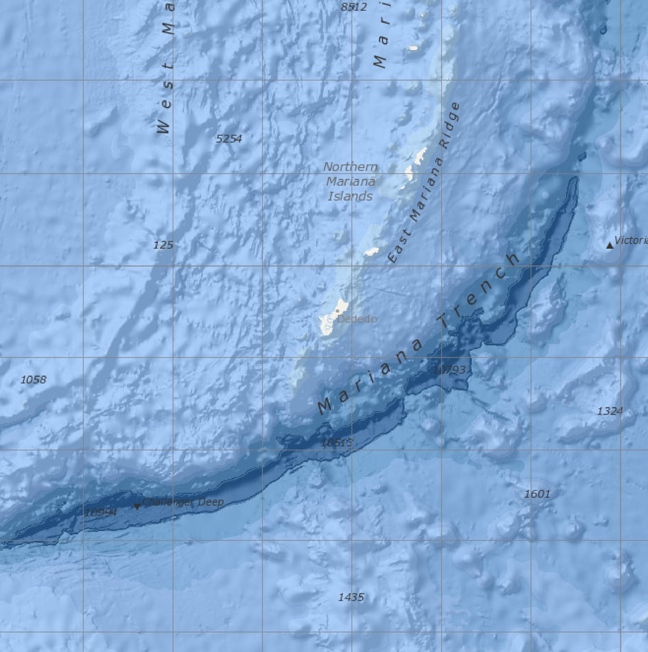
English: Bathymetric map screenshot of the NOAA Marine Geology Data visualizer, showing the immediate vicinity of Guam. Features named include the Mariana Trench, East Mariana Ridge, and Challenger Deep. Features indicated but not named are Sirena Deep, directly south of Guam, and Nero Deep.
From Version 2.72. of Marine Geology Data, last updated 10/2/2020. |
|||
| Date | ||||
| Source | https://maps.ngdc.noaa.gov/viewers/marine_geology/, selection and crop by uploader | |||
| Author | National Centers for Environmental Information, NOAA | |||
| Other versions |
|
Licensing
| Public domainPublic domainfalsefalse |
This work is in the public domain in the United States because it is a work prepared by an officer or employee of the United States Government as part of that person’s official duties under the terms of Title 17, Chapter 1, Section 105 of the US Code.
Note: This only applies to original works of the Federal Government and not to the work of any individual U.S. state, territory, commonwealth, county, municipality, or any other subdivision. This template also does not apply to postage stamp designs published by the United States Postal Service since 1978. (See § 313.6(C)(1) of Compendium of U.S. Copyright Office Practices). It also does not apply to certain US coins; see The US Mint Terms of Use.
|
 | |
| This file has been identified as being free of known restrictions under copyright law, including all related and neighboring rights. | ||
https://creativecommons.org/publicdomain/mark/1.0/PDMCreative Commons Public Domain Mark 1.0falsefalse
Captions
Add a one-line explanation of what this file represents
Items portrayed in this file
depicts
2 October 2020
image/jpeg
0f708124191ac1d0cd160cf4ef110e5d410c8cfe
375,837 byte
2,071 pixel
2,058 pixel
File history
Click on a date/time to view the file as it appeared at that time.
| Date/Time | Thumbnail | Dimensions | User | Comment | |
|---|---|---|---|---|---|
| current | 23:04, 13 March 2021 | | 2,058 × 2,071 (367 KB) | Featous | File:Bathymetric map of Guam.pdf cropped using CropTool with lossless mode. Making JPG. |
File usage
The following pages on the English Wikipedia use this file (pages on other projects are not listed):
Global file usage
The following other wikis use this file:
- Usage on nl.wikipedia.org
- Usage on zh.wikipedia.org
Retrieved from "https://en.wikipedia.org/wiki/File:Bathymetric_map_of_Guam.jpg"